Bannerdale Crags

Hill, Mountain in Cumberland Eden

England

Bannerdale Crags

Mountain walker on path approaching Scales Beck Scales Beck is descending to join the River Glenderamackin. The path by which the walker is approaching crosses the stream at the camera's location then continues to Scales Tarn and climbs beyond it.
The slopes of Bannerdale Crags rise beyond the river in the valley bottom.
Mountain walker on path approaching Scales Beck Credit: Trevor Littlewood

Bannerdale Crags is a prominent and picturesque hill located in the heart of the Lake District National Park in Cumberland, England. Rising to an elevation of 683 meters (2,241 feet), it is classified as a Wainwright Fell, named after Alfred Wainwright, the renowned British fellwalker and author.

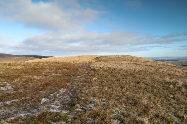
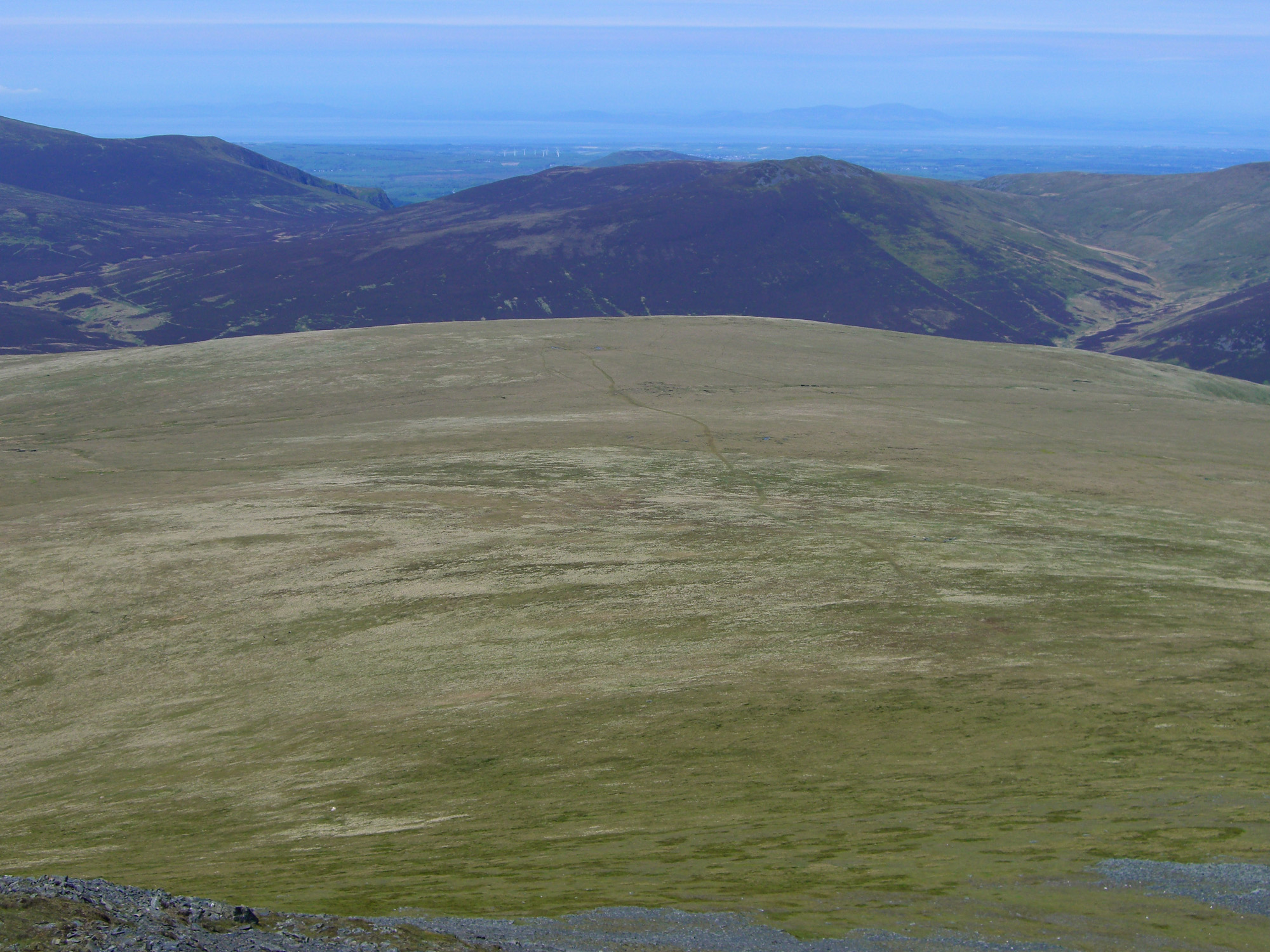
Situated in the northern part of the Lake District, Bannerdale Crags is part of a group of hills known as the Northern Fells. Its distinctive silhouette can be seen from miles around, with its rocky crags and steep slopes making it a challenging but rewarding ascent for hikers and mountaineers alike.

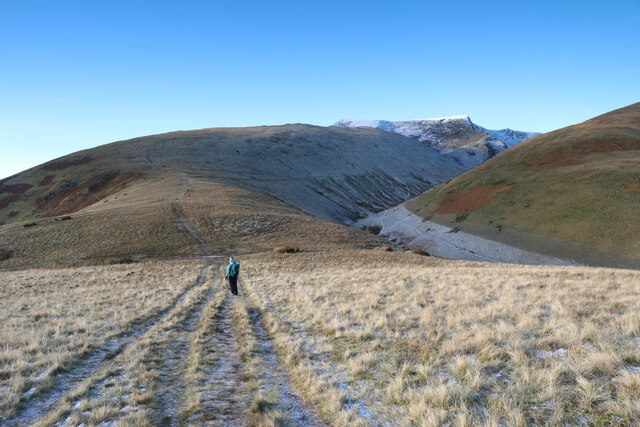
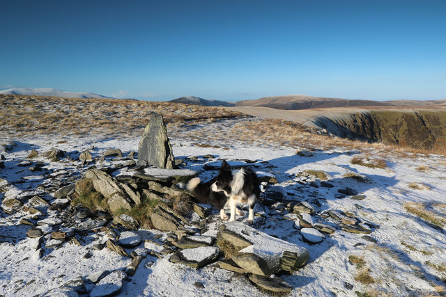
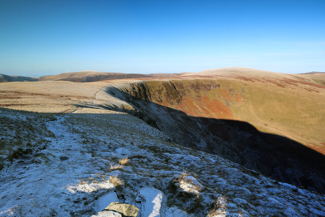
The hill is characterized by its rugged terrain, covered in heather and grasses, interspersed with rocky outcrops and scree slopes. The summit provides breathtaking panoramic views of the surrounding fells, including Skiddaw, the fourth highest peak in England. On a clear day, it is even possible to catch a glimpse of the Scottish coastline to the north.

Bannerdale Crags is a popular destination for outdoor enthusiasts, offering a variety of walking routes to suit all abilities. The most common approach is from the village of Mungrisdale, where a well-defined path leads up the eastern flank of the hill. Alternatively, more experienced walkers can tackle the challenging ridge traverse from Bowscale Fell to the south.

Whether scaling its slopes or admiring it from afar, Bannerdale Crags is a notable landmark in the Lake District, attracting visitors with its natural beauty and providing an unforgettable experience for those who venture to its summit.

If you have any feedback on the listing, please let us know in the comments section below.

Bannerdale Crags Images

Images are sourced within 2km of 54.651914/-3.0316642 or Grid Reference NY3329. Thanks to Geograph Open Source API. All images are credited.

Mountain walker on path approaching Scales Beck Scales Beck is descending to join the River Glenderamackin. The path by which the walker is approaching crosses the stream at the camera's location then continues to Scales Tarn and climbs beyond it.
The slopes of Bannerdale Crags rise beyond the river in the valley bottom.
Mountain walker on path approaching Scales Beck
Scales Beck is descending to join the River Glenderamackin. The path by which the walker is approaching crosses the stream at the camera's location then continues to Scales Tarn and climbs beyond it. The slopes of Bannerdale Crags rise beyond the river in the valley bottom.
Declining eastern slope of Scales Fell The gentle slope is descending to the col on the north side of Mousthwaite Comb beyond which rises Souther Fell.
Declining eastern slope of Scales Fell
The gentle slope is descending to the col on the north side of Mousthwaite Comb beyond which rises Souther Fell.
Lake District under snow Seen from Hartside Pass looking across the Vale of Eden, Blencathra (to the left) and Skiddaw.
Lake District under snow
Seen from Hartside Pass looking across the Vale of Eden, Blencathra (to the left) and Skiddaw.
Concrete Ring Trigonometrical Station Detail of the Ordnance Survey trigonometrical station on the summit of Blencathra, marked by a concrete ring.  Named by the Ordnance Survey as Saddleback using the Victorian name for the fell popular until the 1960s, the 2” brass bolt in the centre of the ring set into a concrete block and marking the precise coordinates of the station is covered by debris. The trigonometrical station marks a point 867.460m above sea level (Ordnance Datum Newlyn) last levelled in 1953 (location photograph <a href="https://www.geograph.org.uk/photo/7236793">NY3227 : Summit of Blencathra</a>).
The concrete ring was removed by vandals in 2018 and was replaced by a new ring in 2019.
Concrete Ring Trigonometrical Station
Detail of the Ordnance Survey trigonometrical station on the summit of Blencathra, marked by a concrete ring. Named by the Ordnance Survey as Saddleback using the Victorian name for the fell popular until the 1960s, the 2” brass bolt in the centre of the ring set into a concrete block and marking the precise coordinates of the station is covered by debris. The trigonometrical station marks a point 867.460m above sea level (Ordnance Datum Newlyn) last levelled in 1953 (location photograph NY3227 : Summit of Blencathra). The concrete ring was removed by vandals in 2018 and was replaced by a new ring in 2019.
Summit of Blencathra At the top of the Hall's Fell Ridge, the summit of Blencathra is adorned by an Ordnance Survey trigonometrical station marked by a concrete ring.  Named by the Ordnance Survey as Saddleback, the Victorian name for the fell, the trigonometrical station marks a point 867.460m above sea level (Ordnance Datum Newlyn) last levelled in 1953 (detail photograph <a href="https://www.geograph.org.uk/photo/7236629">NY3227 : Concrete Ring Trigonometrical Station</a>).
Summit of Blencathra
At the top of the Hall's Fell Ridge, the summit of Blencathra is adorned by an Ordnance Survey trigonometrical station marked by a concrete ring. Named by the Ordnance Survey as Saddleback, the Victorian name for the fell, the trigonometrical station marks a point 867.460m above sea level (Ordnance Datum Newlyn) last levelled in 1953 (detail photograph NY3227 : Concrete Ring Trigonometrical Station).
Summit ridge of Souther Fell After a long gentle diagonal ascent, the path to Souther Fell from Low Beckside emerges onto the ridge, where a bit of backtracking would be needed to visit the very highest point. It's not a terribly distinguished peak, so those engaged on a circular walk with Blencathra or Bannerdale Crags as the high point will probably, as we did, simply bag the square and press on to the southwest.
Summit ridge of Souther Fell
After a long gentle diagonal ascent, the path to Souther Fell from Low Beckside emerges onto the ridge, where a bit of backtracking would be needed to visit the very highest point. It's not a terribly distinguished peak, so those engaged on a circular walk with Blencathra or Bannerdale Crags as the high point will probably, as we did, simply bag the square and press on to the southwest.
That looks a bit icy This is the point on the ascent of Souther Fell when the peaks of Blencathra and Bannerdale Crag first come into good view. The steep paths onto the top of Blencathra can be seen in an exposed position on the left side looking very white, and this is the point where, despite being equipped with ice axes, it was clear that this was not a good day for an ascent by that route (it's a few years since we've had crampons on and we're a bit out of practice). With snow this thin, the rocks are treacherous, but an ice axe isn't going to do much to help stop a fall. Bannerdale Crags proved a fine alternative, with excellent views of Blencathra and Skiddaw.
That looks a bit icy
This is the point on the ascent of Souther Fell when the peaks of Blencathra and Bannerdale Crag first come into good view. The steep paths onto the top of Blencathra can be seen in an exposed position on the left side looking very white, and this is the point where, despite being equipped with ice axes, it was clear that this was not a good day for an ascent by that route (it's a few years since we've had crampons on and we're a bit out of practice). With snow this thin, the rocks are treacherous, but an ice axe isn't going to do much to help stop a fall. Bannerdale Crags proved a fine alternative, with excellent views of Blencathra and Skiddaw.
Ascent of White Horse Bent From the footbridge over the River Glenderamackin, a steep ascent of White Horse Bent is less well-trodden than the main path towards Blencathra, but visible enough on the ground in clear weather, especially with a heavy frost when it shows up as a white ribbon. This view looks back as the gradient starts to ease off, across the col between Blencathra and Souther Fell. The valley in the distance is carved by the same river that lies in the nearer shadowed depths, as it loops right round Souther Fell to flow to a confluence with St. Johns Beck to form the River Greta.
Ascent of White Horse Bent
From the footbridge over the River Glenderamackin, a steep ascent of White Horse Bent is less well-trodden than the main path towards Blencathra, but visible enough on the ground in clear weather, especially with a heavy frost when it shows up as a white ribbon. This view looks back as the gradient starts to ease off, across the col between Blencathra and Souther Fell. The valley in the distance is carved by the same river that lies in the nearer shadowed depths, as it loops right round Souther Fell to flow to a confluence with St. Johns Beck to form the River Greta.
Over White Horse Bent to Blencathra From the path which descends Souther Fell to a col marking a junction of routes to Blencathra, Bannerdale Crags and the valleys below, the view contemplates both our intended route up Blencathra, and our actual discretion-is-the-better-part-of-valour route up White Horse Bent and on to Bannerdale Crags. The snow is visually attractive, but there's not enough of it for ice-braking in a fall, whilst the rocks are pretty treacherous and steep, in an exposed position. We decided we'd not had crampons on recently enough to be in practice for that level of difficulty - like all these mountains it will still be here next time and it's best to ensure that we will be, too !
Over White Horse Bent to Blencathra
From the path which descends Souther Fell to a col marking a junction of routes to Blencathra, Bannerdale Crags and the valleys below, the view contemplates both our intended route up Blencathra, and our actual discretion-is-the-better-part-of-valour route up White Horse Bent and on to Bannerdale Crags. The snow is visually attractive, but there's not enough of it for ice-braking in a fall, whilst the rocks are pretty treacherous and steep, in an exposed position. We decided we'd not had crampons on recently enough to be in practice for that level of difficulty - like all these mountains it will still be here next time and it's best to ensure that we will be, too !
The col above Mousthwaite Cove A broad footpath descends from Souther Fell towards the col which falls steeply to the south into Mousthwaite Cove (to the left in this view). To the right, a path drops to cross the infant River Glenderamackin by a footbridge to ascend its left bank or climb White Horse Bent onto Bannerdale Crags (or return down-valley to Mungrisdale). Directly ahead, paths climb the ridge of Scales Fell in a direct assault on Blencathra, whilst another traverses above the River to reach Scales Tarn and a steeper path to the summit, or an exposed and exciting ridge - Sharp Edge which would be perhaps quite difficult in these conditions. We'd already decided that the snow would not be deep enough for ice axe braking in the event of a fall, whilst even the frozen turf was already treacherous enough without adding exposure and icy rocks, so our route was to be up the horizon line to the right.
The col above Mousthwaite Cove
A broad footpath descends from Souther Fell towards the col which falls steeply to the south into Mousthwaite Cove (to the left in this view). To the right, a path drops to cross the infant River Glenderamackin by a footbridge to ascend its left bank or climb White Horse Bent onto Bannerdale Crags (or return down-valley to Mungrisdale). Directly ahead, paths climb the ridge of Scales Fell in a direct assault on Blencathra, whilst another traverses above the River to reach Scales Tarn and a steeper path to the summit, or an exposed and exciting ridge - Sharp Edge which would be perhaps quite difficult in these conditions. We'd already decided that the snow would not be deep enough for ice axe braking in the event of a fall, whilst even the frozen turf was already treacherous enough without adding exposure and icy rocks, so our route was to be up the horizon line to the right.
Deeply eroded path heads for footbridge over the Glenderamackin From the col above Mousthwaite Cove, those not heading up the hills either side (Blencathra or Souther Fell) have this path to descend to the River Glenderamackin, locked in deep icy shade on this chilly winter's day. On the far side of the river, the main path from Mungrisdale traverses above the river, whilst a thin white streaks marks the direct ascent of White Horse Bent heading for Bannerdale Crags. Peeking out at the head of the valley, Sharp Edge rise to Blencathra - quite a technical challenge in icy conditions and not one we were up for today !
Deeply eroded path heads for footbridge over the Glenderamackin
From the col above Mousthwaite Cove, those not heading up the hills either side (Blencathra or Souther Fell) have this path to descend to the River Glenderamackin, locked in deep icy shade on this chilly winter's day. On the far side of the river, the main path from Mungrisdale traverses above the river, whilst a thin white streaks marks the direct ascent of White Horse Bent heading for Bannerdale Crags. Peeking out at the head of the valley, Sharp Edge rise to Blencathra - quite a technical challenge in icy conditions and not one we were up for today !
Brunt Knott from White Horse Bent Blencathra dominates the horizon from an ascent of the rather less technical path up White Horse Bent. Below the crags nestles Scales tarn and to its right, Brunt Knott, in shadow, marks the start of the ridge which culminates in the exposed scramble of Sharp Edge. With only a thin veneer of snow, neither ice axe nor crampons were going to make any of the ascent routes from this side either easy or safe, so we'd revised our plans to walk over Bannerdale Crags instead, providing splendid views across the valley of the infant River Glenderamackin.
Brunt Knott from White Horse Bent
Blencathra dominates the horizon from an ascent of the rather less technical path up White Horse Bent. Below the crags nestles Scales tarn and to its right, Brunt Knott, in shadow, marks the start of the ridge which culminates in the exposed scramble of Sharp Edge. With only a thin veneer of snow, neither ice axe nor crampons were going to make any of the ascent routes from this side either easy or safe, so we'd revised our plans to walk over Bannerdale Crags instead, providing splendid views across the valley of the infant River Glenderamackin.
Easing gradient on the ascent of Bannerdale Crags From the footbridge over the River Glenderamackin, an ascent of Bannerdale Crags starts steep up the face of White Horse Bent, but eases off at about 600m altitude, where the path becomes somewhat fainter. The uninspiring view ahead belies the rather grander vista which opens up as the top of the hill is reached and the path traverses above steep rocky ground to the right.
Easing gradient on the ascent of Bannerdale Crags
From the footbridge over the River Glenderamackin, an ascent of Bannerdale Crags starts steep up the face of White Horse Bent, but eases off at about 600m altitude, where the path becomes somewhat fainter. The uninspiring view ahead belies the rather grander vista which opens up as the top of the hill is reached and the path traverses above steep rocky ground to the right.
Cairn on Bannerdale Crags This is not the highest point of Bannerdale Crags, which lies a short way to the west, but it is the highest point reached by the path which follows the eastern edge of the plateau. The path continues along the edge towards Bowscale Fell.
Cairn on Bannerdale Crags
This is not the highest point of Bannerdale Crags, which lies a short way to the west, but it is the highest point reached by the path which follows the eastern edge of the plateau. The path continues along the edge towards Bowscale Fell.
Path to Blencathra from Bannerdale Crags Significant paths run from the cairn on Bannerdale Crags SW then W towards Blencathra (seen here) and NW along the edge, curving round to Bowscale Fell or along The Tongue to drop steeply to Mungrisdale. Our approach had been by the rather fainter path from the SE, climbing steeply up White Horse Bent from a footbridge over the infant River Glenderamackin.
Path to Blencathra from Bannerdale Crags
Significant paths run from the cairn on Bannerdale Crags SW then W towards Blencathra (seen here) and NW along the edge, curving round to Bowscale Fell or along The Tongue to drop steeply to Mungrisdale. Our approach had been by the rather fainter path from the SE, climbing steeply up White Horse Bent from a footbridge over the infant River Glenderamackin.
Path to Bowscale Fell From just north of its high point, the path along the edge of Bannerdale Crags heads NNW and curves round northwards to ascend Bowscale Fell (the slightly frosted round summit right of centre) with a branch right heading down into the valley of the River Glenderamackin to reach Mungrisdale.
Path to Bowscale Fell
From just north of its high point, the path along the edge of Bannerdale Crags heads NNW and curves round northwards to ascend Bowscale Fell (the slightly frosted round summit right of centre) with a branch right heading down into the valley of the River Glenderamackin to reach Mungrisdale.
Frosty sedges on Bowscale Fell The path up Bowscale Fell was quite icy and surrounded by somewhat taller vegetation than we'd crossed further south on Bannerdale Crags. There was very little in the way of fallen snow, but all the sedges were heavy with frost making the fell look white and snowy from a distance, as does the Skiddaw massif, seven kilometres to the west.
Frosty sedges on Bowscale Fell
The path up Bowscale Fell was quite icy and surrounded by somewhat taller vegetation than we'd crossed further south on Bannerdale Crags. There was very little in the way of fallen snow, but all the sedges were heavy with frost making the fell look white and snowy from a distance, as does the Skiddaw massif, seven kilometres to the west.
Summit shelter From the small summit shelter on Bowscale Fell, a path leads nrthwards to a junction by the pile of stones, with descents down the NNW and ENE ridges towards the valley of the Caldew. To the right of the photo, a path heads just south of east along the Tongue, to end in a steep descent to Mungrisdale. Behind the photographer is our approach path to this point, coming from Bannerdale Crags (or, more distantly, Mungrisdale Common and Blencathra).
Summit shelter
From the small summit shelter on Bowscale Fell, a path leads nrthwards to a junction by the pile of stones, with descents down the NNW and ENE ridges towards the valley of the Caldew. To the right of the photo, a path heads just south of east along the Tongue, to end in a steep descent to Mungrisdale. Behind the photographer is our approach path to this point, coming from Bannerdale Crags (or, more distantly, Mungrisdale Common and Blencathra).
Show me another place!

Bannerdale Crags is located at Grid Ref: NY3329 (Lat: 54.651914, Lng: -3.0316642)

Administrative County: Cumbria

District: Eden

Police Authority: Cumbria

What 3 Words

///servants.thud.denoting. Near Keswick, Cumbria

Nearby Locations

Bannerdale Crags

Related Wikis

Bannerdale Crags

Bannerdale Crags is a fell in the English Lake District. It stands between Blencathra and Bowscale Fell in the Northern Fells. == Topography == Bannerdale...

Bowscale Fell

Bowscale Fell is a hill in the English Lake District. It rises above the village of Mungrisdale in the Northern Fells. Bowscale Fell stands at the extreme...

Blencathra

Blencathra, also known as Saddleback, is one of the most northerly hills in the English Lake District. It has six separate fell tops, of which the highest...

Souther Fell

Souther Fell is a fell in the English Lake District. It stands to the south of Mungrisdale village in the Northern Fells. It is most famous for the appearance...

Mungrisdale Common

Mungrisdale Common, pronounced mun-grize-dl, with emphasis on grize, is a fell in the English Lake District. Although Alfred Wainwright listed it as one...

Mungrisdale

Mungrisdale is a small village and civil parish in the north east of the English Lake District in Cumbria. It is also the name of the valley in which...

Trout Beck (Glenderamackin)

Trout Beck is a 7.6 miles (12.3 km) long stream or beck in the English Lake District, Cumbria. It rises on the northwestern slopes of Great Dodd, with...

Bowscale

Bowscale is a hamlet and former civil parish, now in the parish of Mungrisdale, in the Eden district, in the county of Cumbria, England. In 1931 the parish...

Nearby Amenities

Located within 500m of 54.651914,-3.0316642
Bannerdale Crags
Ele: 684.1
Natural: peak
Source: npe;https://www.hill-bagging.co.uk/mountaindetails.php?qu=S&rf=2332
Wikidata: Q4856943
Wikipedia: en:Bannerdale Crags
Lat/Long: 54.6519273/-3.0314042
Bannerdale Lead Mine
Abandoned: yes
Historic: mine
Is In Country Code: GB
Man Made: mine
Mineral: lead
Source: npe
Lat/Long: 54.6562382/-3.0313542
Man Made: cairn
Lat/Long: 54.6518682/-3.0314389
Saddleback Old Mine
Abandoned: yes
Historic: mine
Man Made: mine
Lat/Long: 54.6527101/-3.0251122
Low Level
Abandoned: yes
Man Made: adit
Lat/Long: 54.6559315/-3.0313583
Graphite Level
Abandoned: yes
Man Made: adit
Lat/Long: 54.6551186/-3.0327912
Upper Level
Abandoned: yes
Man Made: adit
Lat/Long: 54.6558572/-3.0319769
Trial
Abandoned: yes
Man Made: adit
Lat/Long: 54.6559642/-3.0337194
Bench
Material: stone
Seats: 3
Lat/Long: 54.6524134/-3.0305006
Man Made: cairn
Lat/Long: 54.6524105/-3.030504
Abandoned: yes
Historic: mine_adit
Man Made: adit
Lat/Long: 54.6526164/-3.026077
The data included in this document is from www.openstreetmap.org. The data is made available under ODbL.

Have you been to Bannerdale Crags?

Leave your review of Bannerdale Crags below (or comments, questions and feedback).