South Grain Rig

Hill, Mountain in Dumfriesshire

Scotland

South Grain Rig

Road junction Under Loath Knowe with a recently cleared block between two roads.
Road junction Credit: Richard Webb

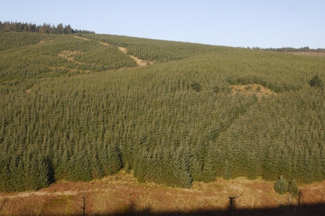
South Grain Rig is a prominent hill located in Dumfriesshire, Scotland. It stands at an elevation of approximately 1,495 feet (456 meters) above sea level. The hill is part of the Southern Uplands, a range of rolling hills and mountains that stretches across the southern region of Scotland.

South Grain Rig is situated near the village of Moffat, offering picturesque views of the surrounding countryside. It is a popular destination for hikers and outdoor enthusiasts, providing an opportunity to experience the natural beauty of the Scottish landscape. The hill is easily accessible via well-marked trails, making it suitable for both experienced and novice hikers.

The terrain of South Grain Rig is characterized by grassy slopes and rocky outcrops, giving it a rugged and wild appearance. The hill is adorned with heather and other native vegetation, creating a colorful display during the summer months. The summit offers panoramic vistas of the surrounding hills, valleys, and distant mountains, making it a rewarding destination for those who reach the top.

South Grain Rig is also home to a variety of wildlife, including red deer, mountain hares, and various bird species. The hill provides a habitat for these creatures, offering a glimpse into the natural diversity of the region.

Overall, South Grain Rig is a captivating hill in Dumfriesshire, offering stunning views, a challenging hike, and a chance to immerse oneself in the beauty of the Scottish countryside.

If you have any feedback on the listing, please let us know in the comments section below.

South Grain Rig Images

Images are sourced within 2km of 55.309912/-3.1113693 or Grid Reference NT2902. Thanks to Geograph Open Source API. All images are credited.

Road junction Under Loath Knowe with a recently cleared block between two roads.
Road junction
Under Loath Knowe with a recently cleared block between two roads.
Road above South Grain One of a pair of logging roads either side of the South Grain burn.
Road above South Grain
One of a pair of logging roads either side of the South Grain burn.
Towards Stock Syke A newly cleared block is visible besides Stock Syke.
Towards Stock Syke
A newly cleared block is visible besides Stock Syke.
Clearfell, Toddle Law The removal of the trees gives a good view along the watershed ridge to Ladshaw Fell. The going in the open areas here is appalling. You have been warned!
Clearfell, Toddle Law
The removal of the trees gives a good view along the watershed ridge to Ladshaw Fell. The going in the open areas here is appalling. You have been warned!
Stock Hill Clear fell reveals a view of the big ridge clearing on Stock Hill. Any progress in that unplanted strip is arduous and awkward and will lead to sweary words.
Stock Hill
Clear fell reveals a view of the big ridge clearing on Stock Hill. Any progress in that unplanted strip is arduous and awkward and will lead to sweary words.
Road on Toddle Knowe A bit to the west of this 2009 image <a href="https://www.geograph.org.uk/photo/1413900">NT3002 : Toddle Knowe</a> but the same forestry blocks. Not much in the way of views here, but the road is preferable to the horror show that is the exact watershed.
Road on Toddle Knowe
A bit to the west of this 2009 image NT3002 : Toddle Knowe but the same forestry blocks. Not much in the way of views here, but the road is preferable to the horror show that is the exact watershed.
Forest road near Toddle Knowe Descending to the Rae Burn glen through dense Sitka.
Forest road near Toddle Knowe
Descending to the Rae Burn glen through dense Sitka.
Deep peat The road has exposed deep peat deposits under Eskdalemuir Forest on Toddle Knowe.
Deep peat
The road has exposed deep peat deposits under Eskdalemuir Forest on Toddle Knowe.
Forest road junction Left for Raeburnhead and Eskdalemuir, right for a loop around the headwaters of the Rae Burn, or a new road over the watershed into Craik Forest.
Forest road junction
Left for Raeburnhead and Eskdalemuir, right for a loop around the headwaters of the Rae Burn, or a new road over the watershed into Craik Forest.
Clearfell on Roney Rig Catching the low sun on the other side of the Rae Burn.
Clearfell on Roney Rig
Catching the low sun on the other side of the Rae Burn.
Road, South Grain Rig A logging road and passing place cut into the side of the Rae Burn glen. The trees are pretty mature here and in the strong wind, this was not a place to linger.
Road, South Grain Rig
A logging road and passing place cut into the side of the Rae Burn glen. The trees are pretty mature here and in the strong wind, this was not a place to linger.
Mature Sitka, Rae Bun A view down very steep slopes from the road.
Mature Sitka, Rae Bun
A view down very steep slopes from the road.
Road on the side of South Grain Rig Climbing up from Raeburnhead, the trees will not be there for much longer as they have definitely reached their chop by date.
Road on the side of South Grain Rig
Climbing up from Raeburnhead, the trees will not be there for much longer as they have definitely reached their chop by date.
View over the Rae Burn Forestry on Lamblair Knowe.
View over the Rae Burn
Forestry on Lamblair Knowe.
Roony Rig North side of the Rae Burn.
Roony Rig
North side of the Rae Burn.
Bend in the road, Raeburnhead What is obviously the main spine road for this part of the forest takes a sharp bend on the way down to crossing the Rae Burn. This is also a road junction.
Bend in the road, Raeburnhead
What is obviously the main spine road for this part of the forest takes a sharp bend on the way down to crossing the Rae Burn. This is also a road junction.
Road north of South Grain Rig A logging road runs away from a hairpin bend on the main road.
Road north of South Grain Rig
A logging road runs away from a hairpin bend on the main road.
Raeburnhead Surviving habitation deep in Eskdalemuir Forest.
Raeburnhead
Surviving habitation deep in Eskdalemuir Forest.
Show me another place!

South Grain Rig is located at Grid Ref: NT2902 (Lat: 55.309912, Lng: -3.1113693)

Unitary Authority: Dumfries and Galloway

Police Authority: Dumfries and Galloway

What 3 Words

///wildfires.actor.marathons. Near Teviothead, Scottish Borders

Nearby Locations

South Grain Rig

Related Wikis

Kagyu Samye Ling Monastery and Tibetan Centre

Kagyu Samye Ling Monastery and Tibetan Centre is a Tibetan Buddhist complex associated with the Karma Kagyu school located at Eskdalemuir, Scotland....

Eskdalemuir Observatory

The Eskdalemuir Observatory is a UK national environmental observatory located near Eskdalemuir, Dumfries and Galloway, Scotland. Along with Lerwick and...

Eskdalemuir

Eskdalemuir is a civil parish and small village in Dumfries and Galloway, Scotland, with a population of 265. It is around 10 miles (16 km) north-west...

Holm, Inverness

Holm is a small residential area in the south of the city of Inverness, Scotland. The area lies east of the River Ness. The most prominent structure in...

Have you been to South Grain Rig?

Leave your review of South Grain Rig below (or comments, questions and feedback).