Johnston Hill

Hill, Mountain in Fife

Scotland

Johnston Hill

Field near Glenduckie Looking over a stubble field south-westwards towards Glenduckie.
Field near Glenduckie Credit: Scott Cormie

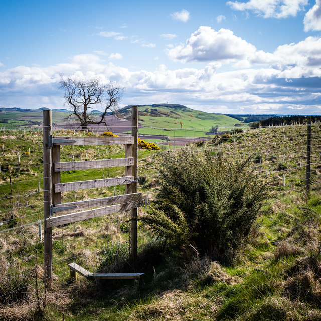
Johnston Hill is a prominent geographical feature located in the region of Fife, Scotland. Rising to an elevation of approximately 291 meters (955 feet), it is classified as a hill rather than a mountain due to its moderate height. Situated in the eastern part of Fife, Johnston Hill forms part of the Lomond Hills, a range of hills that stretches across the region.

The hill itself is characterized by its gently sloping sides and rounded summit, which offers breathtaking panoramic views of the surrounding countryside. The area is rich in natural beauty, with lush green pastures, scattered woodlands, and picturesque farmlands. Johnston Hill is particularly popular among hikers and nature enthusiasts who flock to the region to enjoy the scenic trails and abundant wildlife.

The summit of Johnston Hill provides an ideal vantage point to appreciate the stunning landscape, including views of the nearby towns of Falkland and Glenrothes. On clear days, it is even possible to catch a glimpse of the Firth of Tay and the city of Dundee in the distance. The hill is easily accessible, with several well-maintained footpaths leading to the top.

In addition to its natural attractions, Johnston Hill also holds historical significance. The surrounding area is dotted with remnants of ancient settlements and structures, including prehistoric burial mounds and stone circles. These archaeological sites provide a glimpse into the area's rich and varied past.

Overall, Johnston Hill is a captivating destination that combines natural beauty, historical intrigue, and stunning views, making it a must-visit location for those exploring the Fife region of Scotland.

If you have any feedback on the listing, please let us know in the comments section below.

Johnston Hill Images

Images are sourced within 2km of 56.341783/-3.1461921 or Grid Reference NO2917. Thanks to Geograph Open Source API. All images are credited.

Field near Glenduckie Looking over a stubble field south-westwards towards Glenduckie.
Field near Glenduckie
Looking over a stubble field south-westwards towards Glenduckie.
Field beneath Glenduckie Hill Looking southwards down Glenduckie Hill from the Fife Coastal Path.
Field beneath Glenduckie Hill
Looking southwards down Glenduckie Hill from the Fife Coastal Path.
Sheepfold at Dunboghill
Collairniehill farm ruin
Glenduckie No through road into Glenduckie.
Glenduckie
No through road into Glenduckie.
Path sign, Glenduckie Scottish Rights of Way Society sign.
Path sign, Glenduckie
Scottish Rights of Way Society sign.
Dunbog cemetery Small cemetery near the hamlet of Dunbog. Contains the graves of some surprisingly old people from the local area. Lovely snowdrops in Spring.
Dunbog cemetery
Small cemetery near the hamlet of Dunbog. Contains the graves of some surprisingly old people from the local area. Lovely snowdrops in Spring.
Overgrown greenhouse Glenduckie Triffids perhaps?
Overgrown greenhouse Glenduckie
Triffids perhaps?
Dunbog to Monimail track, looking South West This old unmetalled track runs from Monimail to Dunbog over the North Fife Hills. There is evidence of a route here dating back to the 17th Century
Dunbog to Monimail track, looking South West
This old unmetalled track runs from Monimail to Dunbog over the North Fife Hills. There is evidence of a route here dating back to the 17th Century
Shelter in the hills Three-sided shelter hidden high above Dunbog containing some picnic tables
Shelter in the hills
Three-sided shelter hidden high above Dunbog containing some picnic tables
View across Inchrye reedbeds to Glenduckie and Norman's Law Standing on the Dunbog to Lindores Loch track looking North East. The extensive reedbeds aren't named on the map but lie between Inchrye and Dunbog. On the Northern side is a dismantled railway that used to connect the Den of Lindores with Kilmany and then Wormit ... now long gone. In the distance is Norman's Law, the highest point in the North Fife Hills.
View across Inchrye reedbeds to Glenduckie and Norman's Law
Standing on the Dunbog to Lindores Loch track looking North East. The extensive reedbeds aren't named on the map but lie between Inchrye and Dunbog. On the Northern side is a dismantled railway that used to connect the Den of Lindores with Kilmany and then Wormit ... now long gone. In the distance is Norman's Law, the highest point in the North Fife Hills.
Deer fence and gate Balmeadow Hill Newly planted woodland on Balmeadow Hill is protected with an extensive deer fence. Hopetoun Monument on the skyline.
Deer fence and gate Balmeadow Hill
Newly planted woodland on Balmeadow Hill is protected with an extensive deer fence. Hopetoun Monument on the skyline.
Ruined structure at side of A913
Minor road to Glenduckie
Dunbog windmill One of two new identical wind turbines on the Dunbog to Monimail track. These were erected in July/August 2016 and commissioned shortly afterwards. The image is of the more southerly of the two.
Dunbog windmill
One of two new identical wind turbines on the Dunbog to Monimail track. These were erected in July/August 2016 and commissioned shortly afterwards. The image is of the more southerly of the two.
View to Dunbog Hill and windmills Dunbog Hill is on the right. The track skirts the southern edge of the low lying marshy ground at the foot of Dunbog Hill.
View to Dunbog Hill and windmills
Dunbog Hill is on the right. The track skirts the southern edge of the low lying marshy ground at the foot of Dunbog Hill.
Abandoned cattle feeders Monimail to Dunbog track These cattle feeders are on the old track between Monimail and Dunbog at the junction with the track to Cairneyhill Farm and Lindores Loch. The new wind turbine can just be seen through the haze as the track dips down to Dunbog. This is a good place to stop for a rest when walking or mountain biking over the North Fife Hills. Note that there is at least one additional photograph of these feeders on Geograph mapped to the wrong location.
Abandoned cattle feeders Monimail to Dunbog track
These cattle feeders are on the old track between Monimail and Dunbog at the junction with the track to Cairneyhill Farm and Lindores Loch. The new wind turbine can just be seen through the haze as the track dips down to Dunbog. This is a good place to stop for a rest when walking or mountain biking over the North Fife Hills. Note that there is at least one additional photograph of these feeders on Geograph mapped to the wrong location.
OS Cut Mark: Dunbog, Wall OS Cut Mark: Dunbog, Wall 

NBM WALL JUNC NE SIDE RD
OS Cut Mark: Dunbog, Wall
OS Cut Mark: Dunbog, Wall NBM WALL JUNC NE SIDE RD
Show me another place!

Johnston Hill is located at Grid Ref: NO2917 (Lat: 56.341783, Lng: -3.1461921)

Unitary Authority: Fife

Police Authority: Fife

What 3 Words

///presides.hang.doubts. Near Newburgh, Fife

Related Wikis

Dunbog

Dunbog is a parish in the county of Fife in Scotland which is now (since 1983) united with the neighbouring parish of Abdie, Dunbog kirk closing at that...

Collairnie Castle

Collairnie Castle is an L-plan castle in Dunbog, Fife, Scotland. The castle was extended in the 16th century, with a wing added of 4 storeys with an attic...

Cairnie Hill

Cairnie Hill lies at the eastern end of the Ochil Hills, above the village of Collessie Scotland. It is the highest point of a small upland area between...

Lindores railway station

Lindores railway station served the village of Lindores, Fife, Scotland from 1909 to 1951 on the Newburgh and North Fife Railway. == History == The station...

Lindores Loch

Lindores Loch is a freshwater loch, situated in North Fife in the Parish of Abdie, in the Central Belt of Scotland. The Loch has for many years been used...

Secret Garden (outdoor nursery)

The Secret Garden is an outdoor nursery school in Letham, Fife, Scotland, for children aged 3–7 years. It is a forest kindergarten in which children walk...

Lindores

Lindores is a small village in Fife, Scotland, in the parish of Abdie, about 2 miles south-east of Newburgh. It is situated on the north-east shore of...

Parbroath Castle

Parbroath Castle is a ruined castle which was the former seat of Clan Seton near Parbroath farm, Creich, Fife, Scotland. Only a portion of a vault standing...

Nearby Amenities

Located within 500m of 56.341783,-3.1461921
Balmeadow Hill
Ele: 196
Natural: peak
Lat/Long: 56.3395437/-3.1406301
The data included in this document is from www.openstreetmap.org. The data is made available under ODbL.

Have you been to Johnston Hill?

Leave your review of Johnston Hill below (or comments, questions and feedback).