Bradnor Hill

Hill, Mountain in Herefordshire

England

Bradnor Hill

Cutting bracken on Hergest Ridge
Cutting bracken on Hergest Ridge Credit: Oliver Dixon

Bradnor Hill is a prominent natural landmark located in Herefordshire, England. Rising to a height of 391 meters (1,282 feet), it is classified as a hill rather than a mountain due to its elevation. Situated in the western part of the county, Bradnor Hill offers captivating panoramic views of the surrounding countryside.

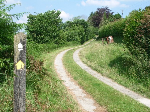
This hill is characterized by its gentle slopes and grassy terrain, making it a popular destination for outdoor enthusiasts and nature lovers. It is covered with a diverse range of vegetation, including wildflowers, heather, and grasses, providing a rich habitat for various wildlife species such as rabbits, foxes, and birds.

The hill is easily accessible by foot, with well-maintained paths leading to its summit. Hikers and walkers can enjoy a pleasant and moderately challenging ascent, rewarded with breathtaking vistas at the top. On a clear day, one can see the Black Mountains and the Brecon Beacons National Park, adding to the allure of the experience.

Bradnor Hill is also steeped in historical significance. At its peak, there are remnants of an Iron Age hillfort, giving visitors a glimpse into the area's ancient past. Additionally, the hill has been used for various recreational activities, including paragliding and kite flying, attracting thrill-seekers and adventure enthusiasts.

Overall, Bradnor Hill in Herefordshire offers a captivating blend of natural beauty, historical intrigue, and outdoor adventure, making it a must-visit destination for those seeking to explore the charm of the English countryside.

If you have any feedback on the listing, please let us know in the comments section below.

Bradnor Hill Images

Images are sourced within 2km of 52.219431/-3.0518841 or Grid Reference SO2858. Thanks to Geograph Open Source API. All images are credited.

Cutting bracken on Hergest Ridge
One man and his dog Out for a walk on Offa's Dyke Path on Hergest Ridge.
One man and his dog
Out for a walk on Offa's Dyke Path on Hergest Ridge.
Offa's Dyke Path on Hergest Ridge
Out for a walk The section of Offa's Dyke Path on Hergest Ridge is extremely popular with walkers.
Out for a walk
The section of Offa's Dyke Path on Hergest Ridge is extremely popular with walkers.
"Welcome to Kington" Notice that greets Offa's Dyke walkers coming down off the bridleway on the Hergest Ridge in to Winterbourne Road in Kington. The town describes itself as "the centre for walking".
"Welcome to Kington"
Notice that greets Offa's Dyke walkers coming down off the bridleway on the Hergest Ridge in to Winterbourne Road in Kington. The town describes itself as "the centre for walking".
"Thank you for visiting Kington" Notice that bids farewell to Offa's Dyke walkers coming up from Winterbourne Road in Kington on to the bridleway on the Hergest Ridge. Kington describes itself as "the centre for walking".
"Thank you for visiting Kington"
Notice that bids farewell to Offa's Dyke walkers coming up from Winterbourne Road in Kington on to the bridleway on the Hergest Ridge. Kington describes itself as "the centre for walking".
Wind sculpture in Hergest Croft Gardens This finely balanced sculpture has three moving parts which rotate with the wind.
Wind sculpture in Hergest Croft Gardens
This finely balanced sculpture has three moving parts which rotate with the wind.
"Origin" Sculpture by Rolf Hook made from  Ledbury Yew (whatever that might be), standing in Hergest Croft Gardens.
"Origin"
Sculpture by Rolf Hook made from Ledbury Yew (whatever that might be), standing in Hergest Croft Gardens.
"Nascence" Sculpture by Rolf Hook made from  Ledbury Yew (whatever that might be), standing in Hergest Croft Gardens.
"Nascence"
Sculpture by Rolf Hook made from Ledbury Yew (whatever that might be), standing in Hergest Croft Gardens.
Stamping station, Offa's Dyke Path For those who wish to authenticate their walk along Offa's Dyke Path, this stamping station is provided beside the path into Hergest Croft Gardens.
Stamping station, Offa's Dyke Path
For those who wish to authenticate their walk along Offa's Dyke Path, this stamping station is provided beside the path into Hergest Croft Gardens.
View to Herrick Hill View to Herrick Hill from Offa's Dyke Path crossing Hergest Ridge. Bradnor Hill is on the right in the middle distance.
View to Herrick Hill
View to Herrick Hill from Offa's Dyke Path crossing Hergest Ridge. Bradnor Hill is on the right in the middle distance.
View north from Hergest Ridge The wooded hill in the middle distance is Navages Wood.  This hill includes Stanners Rocks which at 700 million years old are among the oldest rocks in Wales.
View north from Hergest Ridge
The wooded hill in the middle distance is Navages Wood. This hill includes Stanners Rocks which at 700 million years old are among the oldest rocks in Wales.
Ridgebourne Road Offa's Dyke Path follows Ridgebourne Road as it descends from Hergest Ridge into Kington.
Ridgebourne Road
Offa's Dyke Path follows Ridgebourne Road as it descends from Hergest Ridge into Kington.
Farmland access track Farmland access track just inside England with the wooded hills in the background in Wales and formed of Stanner Rocks, at around 700 million years old among the oldest rocks in Wales.
Farmland access track
Farmland access track just inside England with the wooded hills in the background in Wales and formed of Stanner Rocks, at around 700 million years old among the oldest rocks in Wales.
Field below Bradnor Hill Field below Bradnor Hill just inside England to the west of Kington.
Field below Bradnor Hill
Field below Bradnor Hill just inside England to the west of Kington.
Below Bradnor Hill View across farmland to Bradnor Hill from near Dunfield.
Below Bradnor Hill
View across farmland to Bradnor Hill from near Dunfield.
Farmland below Herrock Hill View over farmland in the broad flat bottom valley below Herrock Hill on the right and the village of Evenjob to the north.
Farmland below Herrock Hill
View over farmland in the broad flat bottom valley below Herrock Hill on the right and the village of Evenjob to the north.
Herrock Hill Herrock Hill, one of a number of steep side hills in this borberland to the west of Kington.
Herrock Hill
Herrock Hill, one of a number of steep side hills in this borberland to the west of Kington.
Show me another place!

Bradnor Hill is located at Grid Ref: SO2858 (Lat: 52.219431, Lng: -3.0518841)

Unitary Authority: County of Herefordshire

Police Authority: West Mercia

What 3 Words

///blubber.skippers.likening. Near Kington, Herefordshire

Nearby Locations

Holywell Wood Bradnor Hill

Related Wikis

Kington Castle

Kington Castle stood in the medieval market town of Kington in Herefordshire, England (grid reference SO291569). It was built in the 11th century and destroyed...

Stanner Rocks

Stanner Rocks is a rounded hill, steep in parts, which lies close to the Wales border with England between Walton and Kington. A superb collection of wild...

Lower Harpton

Lower Harpton is a settlement and civil parish about 2.5 miles of Knighton, in the county of Herefordshire, England. In 2001, the parish had a population...

Church of St Mary, Kington

The Church of St Mary, or St. Mary the Virgin Church, Kington, Herefordshire, England is a Grade I listed parish church. The church was established c....

Nearby Amenities

Located within 500m of 52.219431,-3.0518841
Bradnor Hill
Ele: 391
Natural: peak
Source: npe
Wikidata: Q106691170
Lat/Long: 52.2196171/-3.0518833
Natural: shrub
Lat/Long: 52.2181807/-3.0545436
Information: guidepost
Tourism: information
Lat/Long: 52.2179923/-3.0560178
Information: guidepost
Tourism: information
Lat/Long: 52.2194107/-3.0560195
The data included in this document is from www.openstreetmap.org. The data is made available under ODbL.

Have you been to Bradnor Hill?

Leave your review of Bradnor Hill below (or comments, questions and feedback).