Bakestall

Hill, Mountain in Cumberland Allerdale

England

Bakestall

White Hause from Bakestall Living up to its name. Looking across the valley of Dash Beck, with Dash Farm on the left. The Uldale Fells are in the background.
White Hause from Bakestall Credit: Ian Taylor

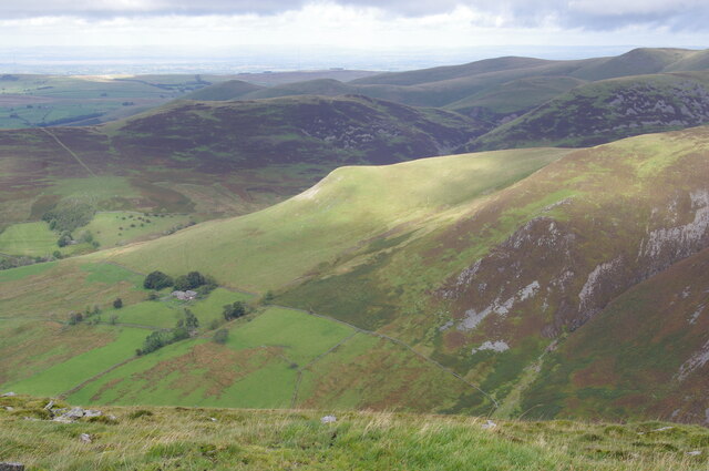
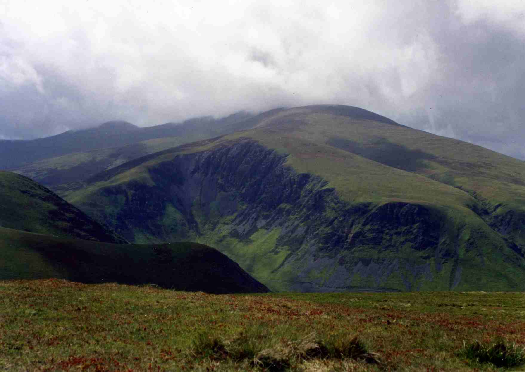
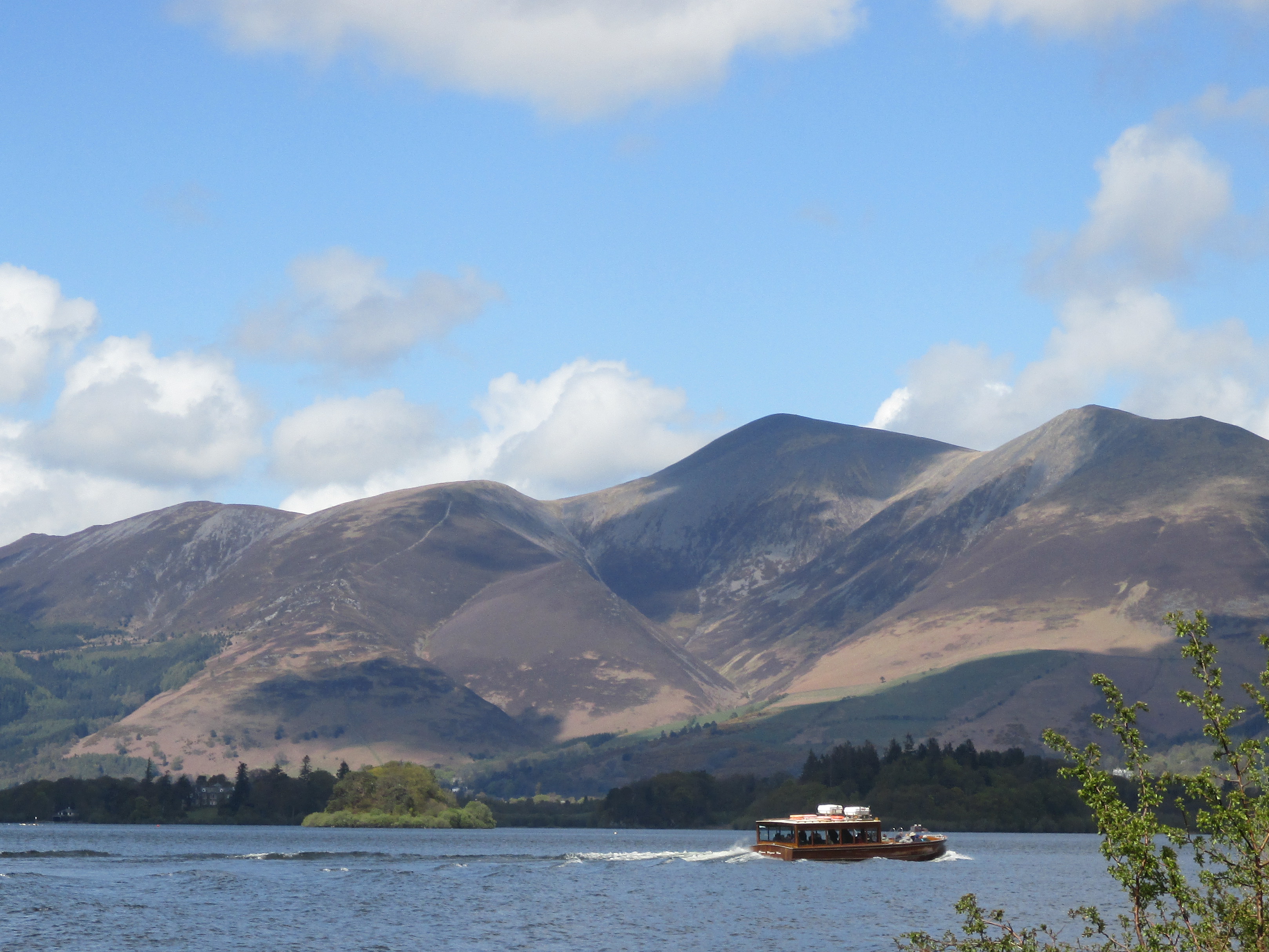
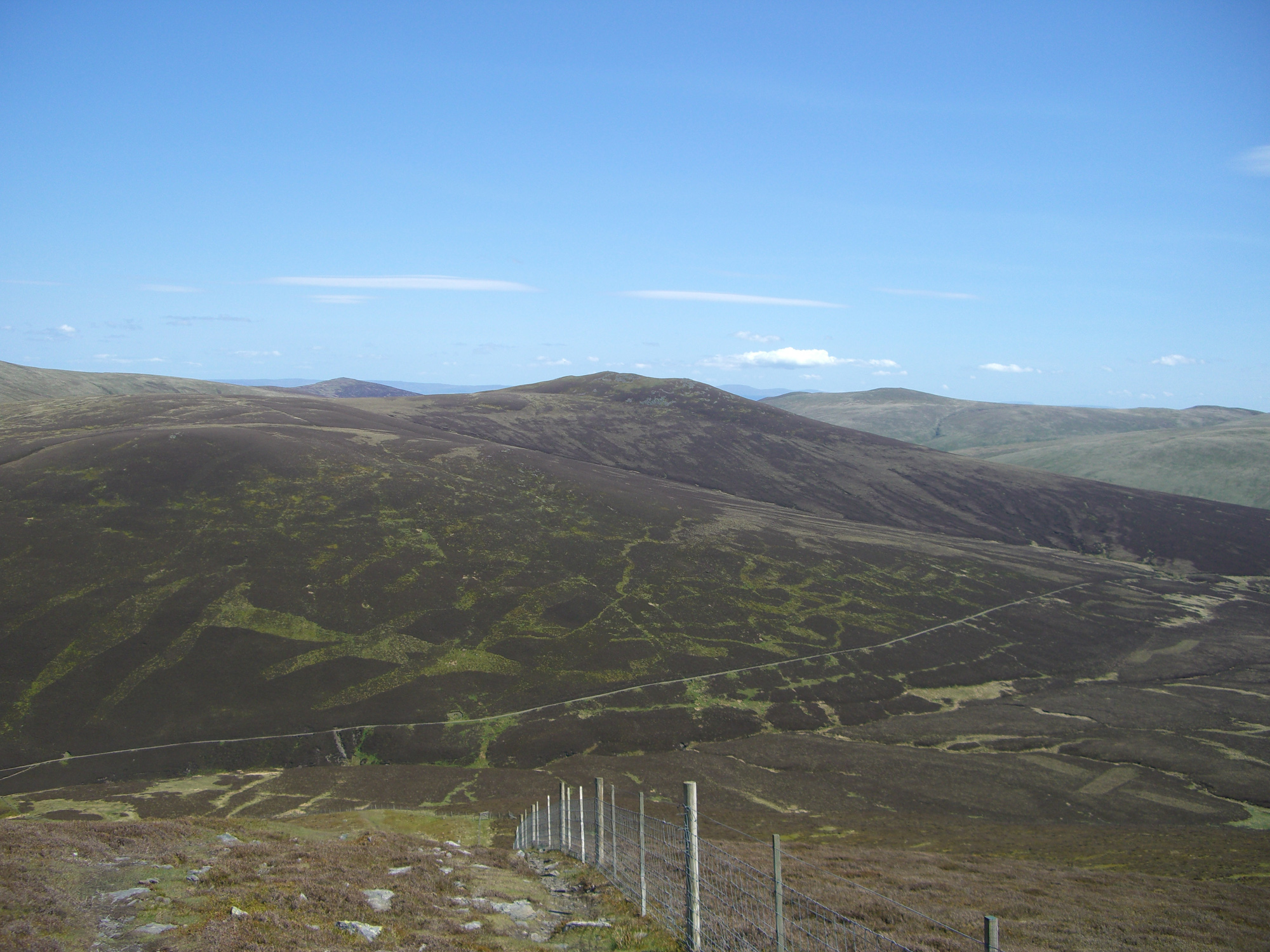
Bakestall is a prominent hill located in the northern part of the Lake District National Park, in the county of Cumbria, England. With an elevation of 673 meters (2,208 feet), it is classified as a Marilyn, a term used to describe hills with a prominence of at least 150 meters (492 feet).

Situated in close proximity to the popular tourist town of Keswick, Bakestall is often climbed as part of a longer hike, such as the Coledale Horseshoe or the Skiddaw range. Although it is not the highest peak in the area, it offers breathtaking panoramic views of the surrounding mountains, including Skiddaw, Great Calva, and Grisedale Pike.

The ascent to Bakestall can be accessed from various starting points, such as the village of Braithwaite or the car park at the base of Dodd Wood. The trail leading to the summit is well-marked and relatively easy to follow, making it suitable for hikers of various skill levels. The final stretch involves a steep climb, but the reward is worth the effort, as the summit offers sweeping vistas of the Lake District's stunning landscape.

Bakestall is a site of great natural beauty and is home to various wildlife species, including birds of prey, such as buzzards and kestrels. The hill attracts outdoor enthusiasts throughout the year, with winter bringing opportunities for snow-covered hikes and summer offering a chance to enjoy the vibrant flora and fauna of the region.

If you have any feedback on the listing, please let us know in the comments section below.

Bakestall Images

Images are sourced within 2km of 54.666346/-3.1391834 or Grid Reference NY2630. Thanks to Geograph Open Source API. All images are credited.

White Hause from Bakestall Living up to its name. Looking across the valley of Dash Beck, with Dash Farm on the left. The Uldale Fells are in the background.
White Hause from Bakestall
Living up to its name. Looking across the valley of Dash Beck, with Dash Farm on the left. The Uldale Fells are in the background.
North from Bakestall A cairn and rocks are just below the summit. Looking across the valley of Dash Beck, with Binsey (centre left), Latrigg and Over Water (right) in the mid distance. Criffell is visible in the far distance on the left, across the Solway Firth.
North from Bakestall
A cairn and rocks are just below the summit. Looking across the valley of Dash Beck, with Binsey (centre left), Latrigg and Over Water (right) in the mid distance. Criffell is visible in the far distance on the left, across the Solway Firth.
The Cumbria Way, Skiddaw Forest The Cumbria Way low level alternative route follows the bridleway from Skiddaw House to Bassenthwaite, climbing out of the upper Caldew Valley near Dead Beck (next photograph <a href="https://www.geograph.org.uk/photo/7009530">NY2830 : The Cumbria Way, Skiddaw Forest near Dead Beck</a>).  The mountain in the background is Little Calva.
The Cumbria Way, Skiddaw Forest
The Cumbria Way low level alternative route follows the bridleway from Skiddaw House to Bassenthwaite, climbing out of the upper Caldew Valley near Dead Beck (next photograph NY2830 : The Cumbria Way, Skiddaw Forest near Dead Beck). The mountain in the background is Little Calva.
The Cumbria Way, Dead Beck The bridleway from Skiddaw House to Bassenthwaite dips down into the small valley of Dead Beck, a tributary of the River Caldew (next photograph <a href="https://www.geograph.org.uk/photo/7013660">NY2830 : The Cumbria Way near Dead Beck</a>).
The Cumbria Way, Dead Beck
The bridleway from Skiddaw House to Bassenthwaite dips down into the small valley of Dead Beck, a tributary of the River Caldew (next photograph NY2830 : The Cumbria Way near Dead Beck).
The Cumbria Way, Skiddaw Forest near Dead Beck The Cumbria Way long distance trail follows the bridleway from Skiddaw House to Bassenthwaite, crossing the lower slopes of Great Calva approaching the valley of Dead Beck (next photograph <a href="https://www.geograph.org.uk/photo/7009523">NY2830 : The Cumbria Way, Dead Beck</a>).  This remote track is the only vehicular access to Skiddaw House Youth Hostel.
The Cumbria Way, Skiddaw Forest near Dead Beck
The Cumbria Way long distance trail follows the bridleway from Skiddaw House to Bassenthwaite, crossing the lower slopes of Great Calva approaching the valley of Dead Beck (next photograph NY2830 : The Cumbria Way, Dead Beck). This remote track is the only vehicular access to Skiddaw House Youth Hostel.
The Cumbria Way near Dead Beck The Cumbria Way low level alternative route follows the bridleway from Skiddaw House to Bassenthwaite as it climbs across the lower slopes of Little Calva (next photograph <a href="https://www.geograph.org.uk/photo/7074080">NY2830 : The Cumbria Way near Dead Beck</a>).
The Cumbria Way near Dead Beck
The Cumbria Way low level alternative route follows the bridleway from Skiddaw House to Bassenthwaite as it climbs across the lower slopes of Little Calva (next photograph NY2830 : The Cumbria Way near Dead Beck).
The Cumbria Way below Dead Crags The Cumbria Way low level alternative route from Caldbeck to Skiddaw House follows the bridleway from Bassenthwaite to Skiddaw House, crossing the steep slopes of Bakestall below Dead Crags before climbing above the cataracts of Whitewater Dash.
This track is the only vehicular access to Skiddaw House Youth Hostel.
The Cumbria Way below Dead Crags
The Cumbria Way low level alternative route from Caldbeck to Skiddaw House follows the bridleway from Bassenthwaite to Skiddaw House, crossing the steep slopes of Bakestall below Dead Crags before climbing above the cataracts of Whitewater Dash. This track is the only vehicular access to Skiddaw House Youth Hostel.
The Cumbria Way near Dead Beck The track is a public bridleway, it is The Cumbria Way low level alternative route from Caldbeck to Skiddaw House and it is the only vehicular access to Skiddaw House Youth Hostel.
The fell in the background is Little Calva with the deep gully of Foul Gill prominent.
The Cumbria Way near Dead Beck
The track is a public bridleway, it is The Cumbria Way low level alternative route from Caldbeck to Skiddaw House and it is the only vehicular access to Skiddaw House Youth Hostel. The fell in the background is Little Calva with the deep gully of Foul Gill prominent.
Dead Crags The lower slopes of the craggy northern ridge of Bakestall, a Wainwright, is crossed by The Cumbria Way long distance path which follows the cart track and public bridleway from Skiddaw House to Peter House Farm, near Bassenthwaite.
Dead Crags
The lower slopes of the craggy northern ridge of Bakestall, a Wainwright, is crossed by The Cumbria Way long distance path which follows the cart track and public bridleway from Skiddaw House to Peter House Farm, near Bassenthwaite.
Bridge over Dash Beck At the top of Black Nettle Hause a short distance above Whitewater Dash, Dash Beck is crossed by this old stone arched bridge.  It carries the access track to Skiddaw House Youth Hostel, which is also a public bridleway and The Cumbria Way low level alternative route from Skiddaw House to Caldbeck.
Bridge over Dash Beck
At the top of Black Nettle Hause a short distance above Whitewater Dash, Dash Beck is crossed by this old stone arched bridge. It carries the access track to Skiddaw House Youth Hostel, which is also a public bridleway and The Cumbria Way low level alternative route from Skiddaw House to Caldbeck.
The Cumbria Way near Dead Beck The Cumbria Way low level alternative route from Skiddaw House to Caldbeck climbs across the slopes of Little Calva near Dead Beck (next photograph <a href="https://www.geograph.org.uk/photo/7074340">NY2830 : The Cumbria Way near Candleseaves Bog</a>).
The Cumbria Way near Dead Beck
The Cumbria Way low level alternative route from Skiddaw House to Caldbeck climbs across the slopes of Little Calva near Dead Beck (next photograph NY2830 : The Cumbria Way near Candleseaves Bog).
The Cumbria Way near Candleseaves Bog The Cumbria Way follows the Skiddaw House access track across the lower slopes of Little Calva (next photograph <a href="https://www.geograph.org.uk/photo/7074378">NY2730 : The Cumbria Way near Candleseaves Bog</a>).
Approximately 488m above sea level, for walkers following the low level alternative route this is the highest point on The Cumbria Way between Ulverston and Carlisle; slightly higher than Stake Pass on the route further south.
The mountain in the left background is Bakestall.
The Cumbria Way near Candleseaves Bog
The Cumbria Way follows the Skiddaw House access track across the lower slopes of Little Calva (next photograph NY2730 : The Cumbria Way near Candleseaves Bog). Approximately 488m above sea level, for walkers following the low level alternative route this is the highest point on The Cumbria Way between Ulverston and Carlisle; slightly higher than Stake Pass on the route further south. The mountain in the left background is Bakestall.
The Cumbria Way near Candleseaves Bog The Cumbria Way low level alternative route follows the Skiddaw House access track and public bridleway across the lower slopes of Little Calva (next photograph <a href="https://www.geograph.org.uk/photo/7076764">NY2730 : The Cumbria Way near Dash Beck</a>).
The Cumbria Way near Candleseaves Bog
The Cumbria Way low level alternative route follows the Skiddaw House access track and public bridleway across the lower slopes of Little Calva (next photograph NY2730 : The Cumbria Way near Dash Beck).
The Cumbria Way near Dash Beck The Cumbria Way low level alternative route follows the public bridleway from Skiddaw House to Bassenthwaite in the upper valley of Dash Beck (next photograph <a href="https://www.geograph.org.uk/photo/7077551">NY2731 : The Cumbria Way near Dash Beck</a>).
The Cumbria Way near Dash Beck
The Cumbria Way low level alternative route follows the public bridleway from Skiddaw House to Bassenthwaite in the upper valley of Dash Beck (next photograph NY2731 : The Cumbria Way near Dash Beck).
Gate on The Cumbria Way This gate crosses the bridleway from Skiddaw House to Bassenthwaite above Whitewater Dash.  The bridleway is The Cumbria Way low level alternative route from Skiddaw House to Caldbeck (next photograph <a href="https://www.geograph.org.uk/photo/7082851">NY2631 : The Cumbria Way by Whitewater Dash</a>).
Gate on The Cumbria Way
This gate crosses the bridleway from Skiddaw House to Bassenthwaite above Whitewater Dash. The bridleway is The Cumbria Way low level alternative route from Skiddaw House to Caldbeck (next photograph NY2631 : The Cumbria Way by Whitewater Dash).
Bridleway above Whitewater Dash The public bridleway is the only vehicular access to Skiddaw house Youth Hostel and it is the route of The Cumbria Way low level alternative from Skiddaw House to Caldbeck (next photograph <a href="https://www.geograph.org.uk/photo/7077532">NY2731 : Gate on The Cumbria Way</a>).
Bridleway above Whitewater Dash
The public bridleway is the only vehicular access to Skiddaw house Youth Hostel and it is the route of The Cumbria Way low level alternative from Skiddaw House to Caldbeck (next photograph NY2731 : Gate on The Cumbria Way).
Bridge over Dash Beck The track from Skiddaw House crosses this small bridge over Dash Beck (photograph <a href="https://www.geograph.org.uk/photo/7064749">NY2731 : Bridge over Dash Beck</a>) near Black Nettle Hause. It is the route of The Cumbria Way low level alternative from Skiddaw House to Caldbeck (next photograph <a href="https://www.geograph.org.uk/photo/7077535">NY2731 : Bridleway above Whitewater Dash</a>).
Bridge over Dash Beck
The track from Skiddaw House crosses this small bridge over Dash Beck (photograph NY2731 : Bridge over Dash Beck) near Black Nettle Hause. It is the route of The Cumbria Way low level alternative from Skiddaw House to Caldbeck (next photograph NY2731 : Bridleway above Whitewater Dash).
The Cumbria Way near Dash Beck The public bridleway from Skiddaw House descends to cross a small bridge over Dash Beck near Black Nettle Hause. It is The Cumbria Way low level alternative route from Skiddaw House to Caldbeck (next photograph <a href="https://www.geograph.org.uk/photo/7077540">NY2731 : Bridge over Dash Beck</a>).
The Cumbria Way near Dash Beck
The public bridleway from Skiddaw House descends to cross a small bridge over Dash Beck near Black Nettle Hause. It is The Cumbria Way low level alternative route from Skiddaw House to Caldbeck (next photograph NY2731 : Bridge over Dash Beck).
Show me another place!

Bakestall is located at Grid Ref: NY2630 (Lat: 54.666346, Lng: -3.1391834)

Administrative County: Cumbria

District: Allerdale

Police Authority: Cumbria

What 3 Words

///prop.dozed.stint. Near Keswick, Cumbria

Nearby Locations

Bakestall

Related Wikis

Bakestall

Bakestall is a fell in the English Lake District, it is situated seven kilometres (4+1⁄4 miles) north of Keswick in the quieter, even secluded northern...

Dash Valley

The Dash Valley is a small valley in the English Lake District. It has only one dwelling, Dash Farm, the fields of which spread right across the valley...

Skiddaw

Skiddaw is a mountain in the Lake District National Park in England. Its 931-metre (3,054 ft) summit is the sixth-highest in England. It lies just north...

Great Calva

Great Calva is a fell in the Lake District, England. It is in the Northern Fells, lying roughly at the centre of this region of high ground. As a result...

Great Cockup

Great Cockup is a fell in the northern region of the English Lake District, one of the four Uldale Fells (the others being Longlands Fell, Great Sca Fell...

Long Side

Long Side is a fell in the English Lake District, it is situated six kilometres north west of Keswick in the northern sector of the national park and is...

Carl Side

Carl Side is a fell in the English Lake District, forming a part of the Skiddaw "family" near the town of Keswick and prominently visible from its streets...

Ullock Pike

Ullock Pike is a fell situated in northern part of the English Lake District. It is located seven kilometres north west of Keswick and achieves a height...

Related Videos

Lake District Walks | Skiddaw via Ullock Pike (a 6 Wainwright walk)

Towering over Keswick in the English Lake District is Skiddaw. At 931-metres (3054 ft), Skiddaw is England's sixth highest ...

Rose Cottage Holiday Cottage, Underskiddaw in the Lake District

bassenthwaite #lakeviews #lakedistrict Rose Cottage oozes Lakeland charm with colourful gardens and lake views. Sleeping five ...

8 Wainwright’s around Skiddaw - A Day Hike : Walking the Lake District Northern Fells.

A clockwise route from Millbeck up to Skiddaw and back, taking in 8 Wainwright's : Dodd, Carl Side, Long Side, Ullock Pike, ...

Carl Side - Fully Labelled Summit View Panorama - Lake District Hikes & Walking : Northern Fells

A slow 360 degree panorama from the summit of Carl Side in the Northern Fells region of the English Lake District. All main ...

Nearby Amenities

Located within 500m of 54.666346,-3.1391834
Bakestall
Ele: 673.5
Natural: peak
Source: npe;https://www.hill-bagging.co.uk/mountaindetails.php?qu=S&rf=2333
Wikidata: Q4849338
Wikipedia: en:Bakestall
Lat/Long: 54.6663541/-3.1390662
Man Made: cairn
Lat/Long: 54.6674208/-3.1390062
Bakestall (Wainwright summit)
Ele: 667.5
Natural: peak
Source: https://www.hill-bagging.co.uk/mountaindetails.php?qu=S&rf=2333
Lat/Long: 54.6674377/-3.1390255
Man Made: cairn
Lat/Long: 54.6664402/-3.1388805
The data included in this document is from www.openstreetmap.org. The data is made available under ODbL.

Have you been to Bakestall?

Leave your review of Bakestall below (or comments, questions and feedback).