Skiddaw

Hill, Mountain in Cumberland Allerdale

England

Skiddaw

Bakestall Bakestall as seen from the northern slope of Skiddaw - it's the sun-dappled dome immediately beyond the near edge of fellside. The 'Back o' Skiddaw' mountains lie further away centred on the bulk of Knott. Bakestall is of course just a minor rise and is part of Skiddaw itself.
Bakestall Credit: Trevor Littlewood

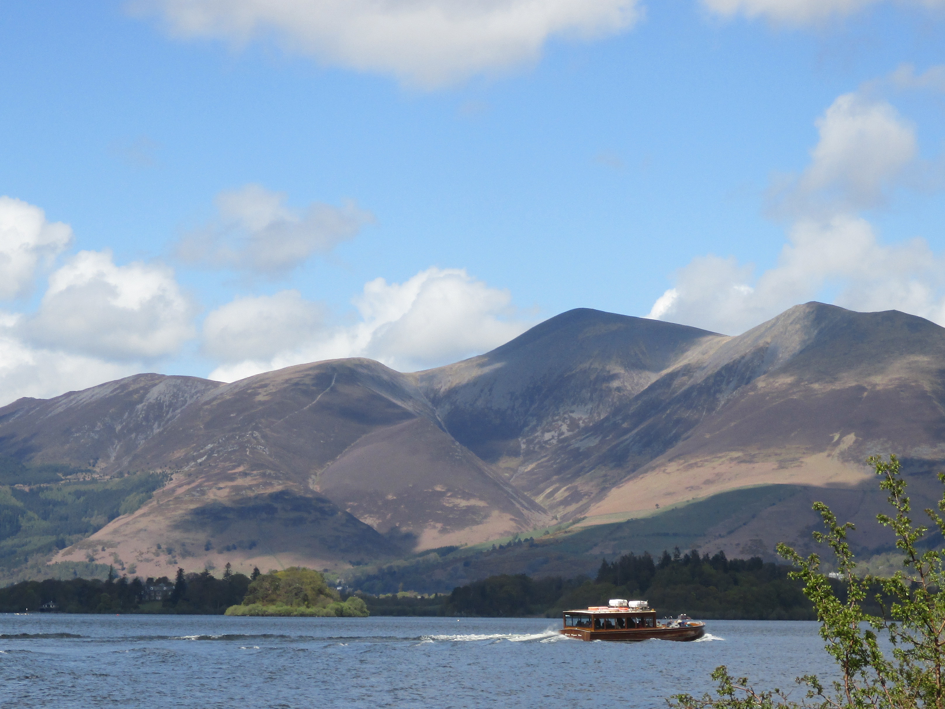
Skiddaw is a prominent hill located in the Lake District National Park, in the county of Cumberland, England. Standing at an impressive height of 931 meters (3,054 feet), it is one of the highest peaks in the region, offering breathtaking panoramic views of the surrounding landscapes.

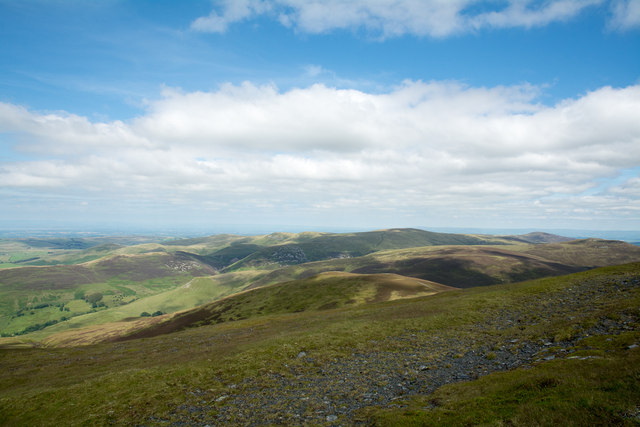
Situated near the town of Keswick, Skiddaw is a popular destination for hikers and nature enthusiasts. The hill's distinctive shape and its close proximity to the town make it easily accessible and attract visitors from all over the world. Its northern slopes are covered with heather and grass, while the southern side boasts a more rugged and rocky terrain.

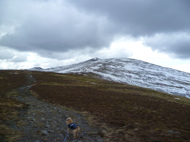
The ascent to Skiddaw's summit is relatively straightforward, with multiple paths leading to the top. The most popular route starts at the base of Latrigg, a neighboring fell, and follows a well-marked trail that gradually ascends towards the peak. From the summit, on clear days, one can admire stunning vistas of the Lake District, including Bassenthwaite Lake, Derwentwater, and the distant peaks of Helvellyn and Scafell Pike.

Skiddaw is known for its unpredictable weather conditions, with mist and fog frequently enveloping the peak, even on seemingly clear days. It is advisable for hikers to come prepared with appropriate clothing and equipment, as the weather can change rapidly at higher altitudes.

With its stunning views, accessible trails, and natural beauty, Skiddaw is a must-visit destination for outdoor enthusiasts and those seeking to explore the scenic wonders of the Lake District.

If you have any feedback on the listing, please let us know in the comments section below.

Skiddaw Images

Images are sourced within 2km of 54.651427/-3.147771 or Grid Reference NY2629. Thanks to Geograph Open Source API. All images are credited.

Bakestall Bakestall as seen from the northern slope of Skiddaw - it's the sun-dappled dome immediately beyond the near edge of fellside. The 'Back o' Skiddaw' mountains lie further away centred on the bulk of Knott. Bakestall is of course just a minor rise and is part of Skiddaw itself.
Bakestall
Bakestall as seen from the northern slope of Skiddaw - it's the sun-dappled dome immediately beyond the near edge of fellside. The 'Back o' Skiddaw' mountains lie further away centred on the bulk of Knott. Bakestall is of course just a minor rise and is part of Skiddaw itself.
Slope of Broad End Broad End is the large bulge of ground that is the northern part of Skiddaw; the view is northwards towards several Cockups!
The minor rise on the same slope as the foreground is simply named Cockup. In the middle distance is a hill ridge; Great Cockup is the higher part of it to the right (east); Little Cockup is the lower western part.
Slope of Broad End
Broad End is the large bulge of ground that is the northern part of Skiddaw; the view is northwards towards several Cockups! The minor rise on the same slope as the foreground is simply named Cockup. In the middle distance is a hill ridge; Great Cockup is the higher part of it to the right (east); Little Cockup is the lower western part.
North from Bakestall A cairn and rocks are just below the summit. Looking across the valley of Dash Beck, with Binsey (centre left), Latrigg and Over Water (right) in the mid distance. Criffell is visible in the far distance on the left, across the Solway Firth.
North from Bakestall
A cairn and rocks are just below the summit. Looking across the valley of Dash Beck, with Binsey (centre left), Latrigg and Over Water (right) in the mid distance. Criffell is visible in the far distance on the left, across the Solway Firth.
A long descent from Skiddaw
The summit cairn on Bakestall A rather insignificant cairn - and actually the slightly lower cairn to the north gives somewhat better views.
The summit cairn on Bakestall
A rather insignificant cairn - and actually the slightly lower cairn to the north gives somewhat better views.
Above Tod Gill Descending through the heather from Bakestall. Hare Crag in shot.
Above Tod Gill
Descending through the heather from Bakestall. Hare Crag in shot.
On Birkett Edge Ascending Bakestall. A steep climb from Dash Falls.
On Birkett Edge
Ascending Bakestall. A steep climb from Dash Falls.
Descending Bakestall Looking towards Great Calva the next objective on the walk.
Descending Bakestall
Looking towards Great Calva the next objective on the walk.
The northern slopes of Skiddaw Knott (710m) is in the distance at the centre of this picture, with Carrock Fell (661m) to the right. I was at about 815m.
The northern slopes of Skiddaw
Knott (710m) is in the distance at the centre of this picture, with Carrock Fell (661m) to the right. I was at about 815m.
Descending Skiddaw On the Broad End flank looking towards Skiddaw summit. In the foreground sits a small stud the purpose of which is unknown to me.
Descending Skiddaw
On the Broad End flank looking towards Skiddaw summit. In the foreground sits a small stud the purpose of which is unknown to me.
On Bakestall On the descent of Skiddaw
On Bakestall
On the descent of Skiddaw
On Birkett Edge A vehicle seen of the track to Skiddaw House
On Birkett Edge
A vehicle seen of the track to Skiddaw House
Looking towards the summit of Bakestall The summit of Bakestall seen from the main cairn on a cloudy and wet November day.
Looking towards the summit of Bakestall
The summit of Bakestall seen from the main cairn on a cloudy and wet November day.
The path down Birkett Edge Looking down the path along Birkett Edge which steeply descends towards the road to Skiddaw House and Dash Beck. Photo taken on a miserable and cloudy November day.
The path down Birkett Edge
Looking down the path along Birkett Edge which steeply descends towards the road to Skiddaw House and Dash Beck. Photo taken on a miserable and cloudy November day.
By Dead Beck Sheltering from the bitter east wind by the beck
By Dead Beck
Sheltering from the bitter east wind by the beck
On Bakestall Looking towards Skiddaw
On Bakestall
Looking towards Skiddaw
Skiddaw Forest From Bakestall
Skiddaw Forest
From Bakestall
Broad End Still winter on the tops
Broad End
Still winter on the tops
Show me another place!

Skiddaw is located at Grid Ref: NY2629 (Lat: 54.651427, Lng: -3.147771)

Administrative County: Cumbria

District: Allerdale

Police Authority: Cumbria

What 3 Words

///wove.book.waving. Near Keswick, Cumbria

Related Wikis

Skiddaw

Skiddaw is a mountain in the Lake District National Park in England. Its 931-metre (3,054 ft) summit is the sixth-highest in England. It lies just north...

Carl Side

Carl Side is a fell in the English Lake District, forming a part of the Skiddaw "family" near the town of Keswick and prominently visible from its streets...

Long Side

Long Side is a fell in the English Lake District, it is situated six kilometres north west of Keswick in the northern sector of the national park and is...

Skiddaw Little Man

Skiddaw Little Man also called Little Man is a fell in the English Lake District, it is situated four kilometres north of the town of Keswick and reaches...

Nearby Amenities

Located within 500m of 54.651427,-3.147771
Skiddaw
Ele: 930.4
Natural: peak
Source: https://www.hill-bagging.co.uk/mountaindetails.php?qu=S&rf=2319
Wikidata: Q2292191
Wikipedia: en:Skiddaw
Lat/Long: 54.651385/-3.1477708
Boeing Flying Fortress B-17E 41-9051 Crash Site
Historic: aircraft_wreck
Note: Approx, within 50m probably. 14th Sept 1943.
Lat/Long: 54.6506601/-3.1491164
Skiddaw
Description: OS trig pillar
Ele: 931.2
Man Made: survey_point
Note: Accurate location import for imagery offset calibration. Please do not move.
Ref: S1543
Source: Ordnance Survey (OGL)
Survey Point: pillar
Lat/Long: 54.6514346/-3.1477813
Man Made: cairn
Lat/Long: 54.6496131/-3.1473906
Check Date: 2023-01-11
Man Made: cairn
Lat/Long: 54.6497792/-3.147405
Man Made: cairn
Lat/Long: 54.6478124/-3.1476357
Avro Anson AX145 crash site
Historic: aircraft_wreck
Lat/Long: 54.6471806/-3.1460696
Tourism: viewpoint
Lat/Long: 54.6514332/-3.1478604
Check Date: 2023-01-11
Man Made: cairn
Lat/Long: 54.6500199/-3.1474171
Check Date: 2023-01-11
Man Made: cairn
Lat/Long: 54.6491512/-3.1473825
Check Date: 2023-01-11
Man Made: cairn
Lat/Long: 54.6485155/-3.1484849
Man Made: cairn
Lat/Long: 54.6470861/-3.14759
Skiddaw South Top
Ele: 925.5
Natural: peak
Source: https://www.hill-bagging.co.uk/mountaindetails.php?qu=S&rf=3693
Lat/Long: 54.6472704/-3.1475999
The data included in this document is from www.openstreetmap.org. The data is made available under ODbL.

Have you been to Skiddaw?

Leave your review of Skiddaw below (or comments, questions and feedback).