Alton Hill

Hill, Mountain in Dumfriesshire

Scotland

Alton Hill

Farmland at Pearsby Hall This improved grazing field was stocked with sheep and cattle. Pearsby Hall Farm is in the background.
Farmland at Pearsby Hall Credit: Walter Baxter

Alton Hill is a prominent hill located in the region of Dumfriesshire, Scotland. Rising to an elevation of approximately 300 meters, it stands as a striking presence in the surrounding landscape. The hill is situated within the Southern Uplands, a picturesque area known for its rolling hills and stunning natural beauty.

Alton Hill offers breathtaking panoramic views of the surrounding countryside, providing visitors with a unique vantage point to appreciate the charm and tranquility of Dumfriesshire. It is easily accessible and attracts both locals and tourists throughout the year.

The hill boasts a diverse range of flora and fauna, with its slopes covered in a patchwork of heathers, grasses, and wildflowers. The area is also home to various species of birds, including buzzards and kestrels, which can often be spotted soaring above the hill.

For outdoor enthusiasts, Alton Hill provides excellent opportunities for walking, hiking, and nature exploration. A network of well-maintained trails allows visitors to traverse the hill, offering both challenging routes and more leisurely strolls. The hill's terrain is relatively gentle, making it suitable for people of all ages and fitness levels.

In addition to its natural beauty, Alton Hill holds historical significance as well. The ruins of a medieval tower, known as Alton Castle, can be found on its slopes. These remnants serve as a reminder of the area's rich heritage and provide a glimpse into the past.

Overall, Alton Hill presents an idyllic destination for those seeking a peaceful escape surrounded by breathtaking scenery and an abundance of outdoor activities.

If you have any feedback on the listing, please let us know in the comments section below.
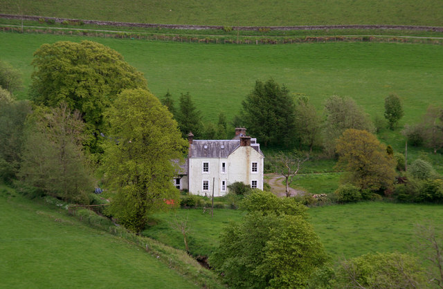
Alton Hill Images

Images are sourced within 2km of 55.149915/-3.1841672 or Grid Reference NY2484. Thanks to Geograph Open Source API. All images are credited.

Farmland at Pearsby Hall This improved grazing field was stocked with sheep and cattle. Pearsby Hall Farm is in the background.
Farmland at Pearsby Hall
This improved grazing field was stocked with sheep and cattle. Pearsby Hall Farm is in the background.
The Cadgill Burn This small hill burn is on the northeast side of Newhall Hill.
The Cadgill Burn
This small hill burn is on the northeast side of Newhall Hill.
Newhall Newhall Farm.
Newhall
Newhall Farm.
Milton House View of Milton House from the side of Birsca.
Milton House
View of Milton House from the side of Birsca.
Newhall Hill Sheep graze some well drained ground on the edge of the Southern Uplands.
Newhall Hill
Sheep graze some well drained ground on the edge of the Southern Uplands.
Country road north of Paddockhole
Water of Milk near Pearsby Hall Looking downstream. The main course of the river follows the bend to the left, but the trees to the right conceal a backwater.
Water of Milk near Pearsby Hall
Looking downstream. The main course of the river follows the bend to the left, but the trees to the right conceal a backwater.
Water of Milk near Milton House Looking downstream. Newhall Farm <a href="https://www.geograph.org.uk/gridref/NY2383">NY2383</a> can be seen to the right.
Water of Milk near Milton House
Looking downstream. Newhall Farm NY2383 can be seen to the right.
Milton House In the valley of the Water of Milk. Newhall Farm <a href="https://www.geograph.org.uk/gridref/NY2383">NY2383</a> can be seen to the right, with forest beyond.
Milton House
In the valley of the Water of Milk. Newhall Farm NY2383 can be seen to the right, with forest beyond.
Water of Milk and Craighousesteads Farm Looking upstream.
Water of Milk and Craighousesteads Farm
Looking upstream.
Water of Milk Looking upstream towards Capelfoot Farm <a href="https://www.geograph.org.uk/gridref/NY2386">NY2386</a>. The farm bridge giving access to Craighousesteads Farm in the foreground.
Water of Milk
Looking upstream towards Capelfoot Farm NY2386. The farm bridge giving access to Craighousesteads Farm in the foreground.
B7068 at Paddockhole  Looking east towards Langholm, eventually.
B7068 at Paddockhole
Looking east towards Langholm, eventually.
Minor road and bridge near to Craighousesteads Looking southward. Palmer's Syke flows under the bridge on its way to join Water of Milk.
Minor road and bridge near to Craighousesteads
Looking southward. Palmer's Syke flows under the bridge on its way to join Water of Milk.
Minor road heading towards Craighousesteads Looking north-eastward.
Minor road heading towards Craighousesteads
Looking north-eastward.
Minor road heading towards Paddockhole Looking southward.
Minor road heading towards Paddockhole
Looking southward.
Minor road near to Brisca Looking northward.
Minor road near to Brisca
Looking northward.
Minor road descending towards Paddockhole Looking southward.
Minor road descending towards Paddockhole
Looking southward.
Ordnance Survey Cut Mark This mark can be found on the top of a road bridge near Craighousesteads.
The recorded details give a height of 165.44 metres above sea level.
For more details see : <span class="nowrap"><a title="https://www.bench-marks.org.uk/bm165035" rel="nofollow ugc noopener" href="https://www.bench-marks.org.uk/bm165035">Link</a><img style="margin-left:2px;" alt="External link" title="External link - shift click to open in new window" src="https://s1.geograph.org.uk/img/external.png" width="10" height="10"/></span>
Ordnance Survey Cut Mark
This mark can be found on the top of a road bridge near Craighousesteads. The recorded details give a height of 165.44 metres above sea level. For more details see : LinkExternal link
Show me another place!

Alton Hill is located at Grid Ref: NY2484 (Lat: 55.149915, Lng: -3.1841672)

Unitary Authority: Dumfries and Galloway

Police Authority: Dumfries and Galloway

What 3 Words

///repayment.conned.apes. Near Bentpath, Dumfries & Galloway

Related Wikis

Annandale and Eskdale

Annandale and Eskdale is a committee area in Dumfries and Galloway, Scotland. It covers the areas of Annandale and Eskdale, the straths of the River Annan...

Whitcastles stone circle

Whitcastles or Little Hartfell (grid reference NY 2240 8806) is a stone circle 6½ miles NE of Lockerbie, Dumfries and Galloway. Nine fallen stones lie...

Burnswark Hill

Burnswark Hill (also known as Birrenswark), to the east of the A74(M) between Ecclefechan and Lockerbie in Dumfries and Galloway, Scotland, is a prominent...

Scotsbrig

Scotsbrig is a farm near Ecclefechan, Dumfries and Galloway, Scotland, and a Category B listed building. Thomas Carlyle lived there with his family in...
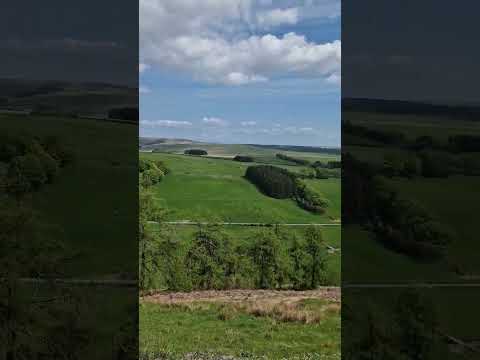
Related Videos

Have you been to Alton Hill?

Leave your review of Alton Hill below (or comments, questions and feedback).