Barkbeth Hill

Hill, Mountain in Cumberland Allerdale

England

Barkbeth Hill

Gates near Peter House Farm The public bridleway from Skiddaw House to Bassenthwaite and the low level alternative route of The Cumbria Way cross the road here (next photograph <a href="https://www.geograph.org.uk/photo/7112133">NY2432 : Gate and Stile near Peter House Farm</a>).
Gates near Peter House Farm Credit: Adrian Taylor

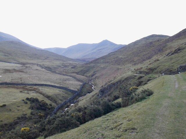
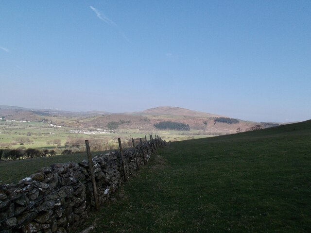
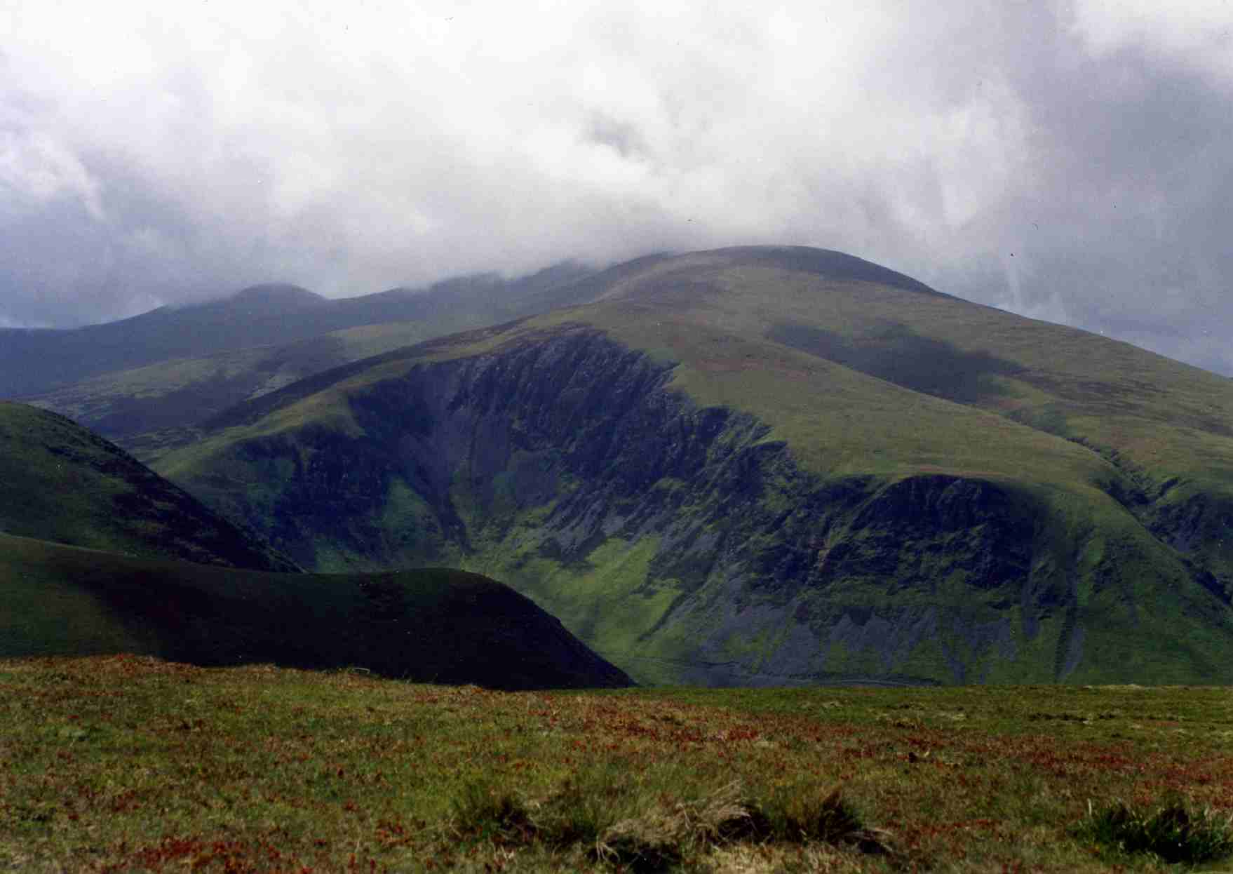
Barkbeth Hill is a prominent geographical feature located in the county of Cumberland, England. It is commonly referred to as both a hill and a mountain due to its impressive elevation and rugged terrain. Standing at a height of approximately 2,218 feet (676 meters), it offers breathtaking panoramic views of the surrounding countryside.

Situated within the picturesque Lake District National Park, Barkbeth Hill attracts hikers, mountaineers, and nature enthusiasts from all over the world. The hill features a challenging yet rewarding ascent, with a variety of paths and trails leading to its summit. Its rocky slopes and steep gradients provide an exhilarating experience for those seeking outdoor adventure.

The vegetation on Barkbeth Hill is diverse, ranging from heather-covered moorland to patches of ancient woodland. This creates a rich habitat for various wildlife, including birds of prey, wild deer, and rare plant species. The hill is also known for its picturesque waterfalls and streams, adding to its natural beauty.

Barkbeth Hill is steeped in history and folklore, with ancient stone circles and burial mounds found in its vicinity. It is believed to have been an important site for ritual and ceremonial practices in ancient times.

Overall, Barkbeth Hill is a must-visit destination for those seeking a challenging outdoor experience, stunning views, and a connection to the rich history and natural beauty of Cumberland.

If you have any feedback on the listing, please let us know in the comments section below.

Barkbeth Hill Images

Images are sourced within 2km of 54.668924/-3.178718 or Grid Reference NY2431. Thanks to Geograph Open Source API. All images are credited.

Gates near Peter House Farm The public bridleway from Skiddaw House to Bassenthwaite and the low level alternative route of The Cumbria Way cross the road here (next photograph <a href="https://www.geograph.org.uk/photo/7112133">NY2432 : Gate and Stile near Peter House Farm</a>).
Gates near Peter House Farm
The public bridleway from Skiddaw House to Bassenthwaite and the low level alternative route of The Cumbria Way cross the road here (next photograph NY2432 : Gate and Stile near Peter House Farm).
The Cumbria Way near Peter House Farm The Cumbria Way low level alternative route from Skiddaw House to Caldbeck follows the Dash Farm access road on the approach to Peter House Farm.  The access road is the also the public bridleway from Skiddaw House to Bassenthwaite and the only vehicular access to Skiddaw House Youth Hostel (next photograph <a href="https://www.geograph.org.uk/photo/7097243">NY2432 : Gates near Peter House Farm</a>).
The Cumbria Way near Peter House Farm
The Cumbria Way low level alternative route from Skiddaw House to Caldbeck follows the Dash Farm access road on the approach to Peter House Farm. The access road is the also the public bridleway from Skiddaw House to Bassenthwaite and the only vehicular access to Skiddaw House Youth Hostel (next photograph NY2432 : Gates near Peter House Farm).
Farm access road near Springsyke The road is a public bridleway and the route of The Cumbria Way low level alternative route from Skiddaw House to Caldbeck (next photograph <a href="https://www.geograph.org.uk/photo/7097246">NY2432 : The Cumbria Way near Peter House Farm</a>).
Farm access road near Springsyke
The road is a public bridleway and the route of The Cumbria Way low level alternative route from Skiddaw House to Caldbeck (next photograph NY2432 : The Cumbria Way near Peter House Farm).
Farm access road near Springsyke The road provides access to Dash Farm and Skiddaw House.  It is the low level alternative route of The Cumbria Way between Skiddaw House and Caldbeck (next photograph <a href="https://www.geograph.org.uk/photo/7097251">NY2532 : Farm access road near Springsyke</a>).
The fell in the background is Binsey; the northernmost of the Wainwrights (photograph <a href="https://www.geograph.org.uk/photo/7582811">NY2233 : Binsey</a>).
Farm access road near Springsyke
The road provides access to Dash Farm and Skiddaw House. It is the low level alternative route of The Cumbria Way between Skiddaw House and Caldbeck (next photograph NY2532 : Farm access road near Springsyke). The fell in the background is Binsey; the northernmost of the Wainwrights (photograph NY2233 : Binsey).
Gate near Springsyke The gated access road is the route of The Cumbria Way low level alternative route from Skiddaw House to Caldbeck (next photograph <a href="https://www.geograph.org.uk/photo/7097255">NY2532 : Farm access road near Springsyke</a>).
Gate near Springsyke
The gated access road is the route of The Cumbria Way low level alternative route from Skiddaw House to Caldbeck (next photograph NY2532 : Farm access road near Springsyke).
The Cumbria Way near Springsyke The road provides access to Dash Farm and Skiddaw House.  It is the low level alternative route of The Cumbria Way between Skiddaw House and Caldbeck (next photograph <a href="https://www.geograph.org.uk/photo/7097260">NY2532 : Gate near Springsyke</a>).
The Cumbria Way near Springsyke
The road provides access to Dash Farm and Skiddaw House. It is the low level alternative route of The Cumbria Way between Skiddaw House and Caldbeck (next photograph NY2532 : Gate near Springsyke).
Gate on The Cumbria Way The gated access road is a public bridleway and the route of The Cumbria Way low level alternative route from Skiddaw House to Caldbeck (next photograph <a href="https://www.geograph.org.uk/photo/7097264">NY2532 : The Cumbria Way near Springsyke</a>).
Gate on The Cumbria Way
The gated access road is a public bridleway and the route of The Cumbria Way low level alternative route from Skiddaw House to Caldbeck (next photograph NY2532 : The Cumbria Way near Springsyke).
Bridleway near Peter House Farm This track is the public bridleway from Peter House Farm to Bassenthwaite and also the low level alternative route of The Cumbria Way from Skiddaw House to Nether Row near Caldbeck (next photograph <a href="https://www.geograph.org.uk/photo/7139220">NY2432 : The Cumbria Way near Peter House Farm</a>).
The rushes indicate that this part of the field is inclined to be boggy.
Bridleway near Peter House Farm
This track is the public bridleway from Peter House Farm to Bassenthwaite and also the low level alternative route of The Cumbria Way from Skiddaw House to Nether Row near Caldbeck (next photograph NY2432 : The Cumbria Way near Peter House Farm). The rushes indicate that this part of the field is inclined to be boggy.
Pasture near Peter House Farm This pasture field is crossed by the public bridleway from Peter House Farm to Bassenthwaite, which is also the low level alternative route of The Cumbria Way.
Northbound walkers on The Cumbria Way will pick up a track between the rushes in the background on the approach to a gate, hidden behind the trees (next photograph <a href="https://www.geograph.org.uk/photo/7112115">NY2432 : Bridleway near Peter House Farm</a>).
Pasture near Peter House Farm
This pasture field is crossed by the public bridleway from Peter House Farm to Bassenthwaite, which is also the low level alternative route of The Cumbria Way. Northbound walkers on The Cumbria Way will pick up a track between the rushes in the background on the approach to a gate, hidden behind the trees (next photograph NY2432 : Bridleway near Peter House Farm).
The Cumbria Way near Peter House Farm This field is crossed by the public bridleway from Peter House Farm to Bassenthwaite, which is also the low level alternative route of The Cumbria Way.
The obvious track is a farm track; the bridleway is not visible on the ground and northbound walkers on The Cumbria Way should cross the field in the direction of the right hand end of the clump of trees (next photograph <a href="https://www.geograph.org.uk/photo/7362844">NY2432 : Field near Peter House Farm</a>).
The Cumbria Way near Peter House Farm
This field is crossed by the public bridleway from Peter House Farm to Bassenthwaite, which is also the low level alternative route of The Cumbria Way. The obvious track is a farm track; the bridleway is not visible on the ground and northbound walkers on The Cumbria Way should cross the field in the direction of the right hand end of the clump of trees (next photograph NY2432 : Field near Peter House Farm).
Gate and Stile near Peter House Farm The stile, almost hidden by the grass and nettles at the end of the hedge, is the alternative route of The Cumbria Way from Skiddaw house to Nether Row near Caldbeck.  Beyond the stile the route follows a public bridleway across the field (next photograph <a href="https://www.geograph.org.uk/photo/7112131">NY2432 : The Cumbria Way near Peter House Farm</a>).
Gate and Stile near Peter House Farm
The stile, almost hidden by the grass and nettles at the end of the hedge, is the alternative route of The Cumbria Way from Skiddaw house to Nether Row near Caldbeck. Beyond the stile the route follows a public bridleway across the field (next photograph NY2432 : The Cumbria Way near Peter House Farm).
Peter House Farm
Peter House Farm
The Cumbria Way Binsey in the distance
The Cumbria Way
Binsey in the distance
Southerndale
Southerndale
Wall in the shadow of the hills looking north
Grazing on Barkbeth Hill
Bridleway near Peter House Farm The public bridleway from Melbecks to Halls Beck and Whitefield Wood runs beside a shelter belt of trees.  It is the low level alternative route of The Cumbria Way from Skiddaw House to Nether Row near Caldbeck (next photograph <a href="https://www.geograph.org.uk/photo/7140438">NY2432 : Field Gate on The Cumbria Way</a>).
Bridleway near Peter House Farm
The public bridleway from Melbecks to Halls Beck and Whitefield Wood runs beside a shelter belt of trees. It is the low level alternative route of The Cumbria Way from Skiddaw House to Nether Row near Caldbeck (next photograph NY2432 : Field Gate on The Cumbria Way).
Bridleways near Peter House Farm Two public bridleways cross here.  Straight ahead the bridleway from Keswick via Skiddaw House and Peter House Farm continues to Bassenthwaite village.  Crossing it is the bridleway from Melbecks to Halls Beck and Whitefield Wood.
Northbound walkers following The Cumbria Way turn right here (next photograph <a href="https://www.geograph.org.uk/photo/7133329">NY2432 : Bridleway near Peter House Farm</a>).
Bridleways near Peter House Farm
Two public bridleways cross here. Straight ahead the bridleway from Keswick via Skiddaw House and Peter House Farm continues to Bassenthwaite village. Crossing it is the bridleway from Melbecks to Halls Beck and Whitefield Wood. Northbound walkers following The Cumbria Way turn right here (next photograph NY2432 : Bridleway near Peter House Farm).
Show me another place!

Barkbeth Hill is located at Grid Ref: NY2431 (Lat: 54.668924, Lng: -3.178718)

Administrative County: Cumbria

District: Allerdale

Police Authority: Cumbria

What 3 Words

///tabs.carpentry.pastels. Near Keswick, Cumbria

Nearby Locations

Barkbeth Hill

Related Wikis

Chapel, Cumbria

Chapel is a hamlet in the English county of Cumbria. Chapel is located on the A591 road between Bassenthwaite and Bassenthwaite Lake. The Cumbria Way crosses...

St Bega's Way

St Bega's Way is a 36-mile (58 km) walk through rural West Cumbria and the north west corner of the English Lake District. It is usually completed as a...

Bassenthwaite

Bassenthwaite is a village and civil parish to the west of Bassenthwaite Lake in Cumbria, historically part of Cumberland, within the Lake District National...

Ullock Pike

Ullock Pike is a fell situated in northern part of the English Lake District. It is located seven kilometres north west of Keswick and achieves a height...

Dash Valley

The Dash Valley is a small valley in the English Lake District. It has only one dwelling, Dash Farm, the fields of which spread right across the valley...

Bakestall

Bakestall is a fell in the English Lake District, it is situated seven kilometres (4+1⁄4 miles) north of Keswick in the quieter, even secluded northern...

Bassenfell Manor

Bassenfell Manor is a manor house in Bassenthwaite, Cumbria, overlooking Bassenthwaite Lake in England's Lake District. It is used as a Christian residential...

Long Side

Long Side is a fell in the English Lake District, it is situated six kilometres north west of Keswick in the northern sector of the national park and is...

Nearby Amenities

Located within 500m of 54.668924,-3.178718
Barkbeth
Place: locality
Lat/Long: 54.6709054/-3.1774484
Barkbeth Hill
Ele: 257
Natural: peak
Lat/Long: 54.6689495/-3.1785341
Barrier: stile
Lat/Long: 54.6700695/-3.1799088
Power: pole
Lat/Long: 54.6730053/-3.1780586
Power: pole
Lat/Long: 54.6706519/-3.1841957
Power: pole
Lat/Long: 54.6697495/-3.183507
Power: pole
Lat/Long: 54.6688315/-3.1846866
Power: pole
Lat/Long: 54.6679977/-3.1857322
Power: pole
Lat/Long: 54.6721579/-3.1778336
Power: pole
Lat/Long: 54.6711913/-3.1775666
Power: pole
Lat/Long: 54.6706603/-3.1774081
Power: pole
Lat/Long: 54.6701607/-3.1782765
The data included in this document is from www.openstreetmap.org. The data is made available under ODbL.

Have you been to Barkbeth Hill?

Leave your review of Barkbeth Hill below (or comments, questions and feedback).