Hard Knott

Hill, Mountain in Cumberland Copeland

England

Hard Knott

They Never Saw This Taken from above the Fort on Hardknott Pass, the Romans would never have seen the fruits of their labours from above like this!
They Never Saw This Credit: Andy Beecroft

Hard Knott is a prominent hill located in the county of Cumberland, England. Rising to a height of 549 meters (1,801 feet) above sea level, it is classified as a Marilyn, which means it is a hill with a prominence of at least 150 meters (492 feet).

Situated in the Lake District National Park, Hard Knott is known for its rugged and steep terrain, making it a popular destination for hikers and mountaineers. The hill is composed of volcanic rock, giving it a distinctive appearance and adding to its appeal for geology enthusiasts.

Hard Knott offers stunning panoramic views of the surrounding landscape, including the neighboring fells of Esk Pike, Bowfell, and Scafell Pike, the highest peak in England. On a clear day, it is possible to see as far as the Isle of Man and the coast of Scotland.

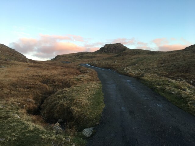
Access to Hard Knott can be challenging due to its remote location and narrow, winding roads. The Hardknott Pass, a famous mountain pass that crosses the hill, is one of the steepest and most challenging roads in the country, with gradients reaching 33%. Therefore, caution and suitable vehicles are necessary when attempting to reach the summit.

The area surrounding Hard Knott is rich in historical sites as well. The remains of a Roman fort, known as Mediobogdum, can be found near the summit, providing a glimpse into the region's ancient past.

Overall, Hard Knott in Cumberland is a remarkable hill that offers breathtaking views, challenging terrain, and a glimpse into both natural and historical wonders.

If you have any feedback on the listing, please let us know in the comments section below.

Hard Knott Images

Images are sourced within 2km of 54.410977/-3.185003 or Grid Reference NY2302. Thanks to Geograph Open Source API. All images are credited.

They Never Saw This Taken from above the Fort on Hardknott Pass, the Romans would never have seen the fruits of their labours from above like this!
They Never Saw This
Taken from above the Fort on Hardknott Pass, the Romans would never have seen the fruits of their labours from above like this!
Near the Top The last couple of hairpin bends of the western approach of Hardknott Pass.
Near the Top
The last couple of hairpin bends of the western approach of Hardknott Pass.
The Final Slog The last few hundred feet of the climb up the western side of Hardknott Pass.
The Final Slog
The last few hundred feet of the climb up the western side of Hardknott Pass.
Cockley Beck from above Wrynose Bottoms The view is looking westwards towards Hardknott Pass.
Cockley Beck from above Wrynose Bottoms
The view is looking westwards towards Hardknott Pass.
Ordnance Survey Cut Mark This OS cut mark can be found on the west face of Dale Head House. It marks a point 198.373m above mean sea level.
Ordnance Survey Cut Mark
This OS cut mark can be found on the west face of Dale Head House. It marks a point 198.373m above mean sea level.
Ordnance Survey Rivet This OS rivet can be found on the wall NW side of the road. It marks a point 207.615m above mean sea level.
Ordnance Survey Rivet
This OS rivet can be found on the wall NW side of the road. It marks a point 207.615m above mean sea level.
Ordnance Survey Cut Mark This OS cut mark can be found on barn at Cockley Beck Farm. It marks a point 216.688m above mean sea level.
Ordnance Survey Cut Mark
This OS cut mark can be found on barn at Cockley Beck Farm. It marks a point 216.688m above mean sea level.
Road towards the Wrynose Pass
Eastern end of the Hardknott Pass
Road over the Hardknott Pass
Up from the West A pair of very fit cyclists making light work of the climb from Eskdale up to the summit of Hardknott Pass.
Up from the West
A pair of very fit cyclists making light work of the climb from Eskdale up to the summit of Hardknott Pass.
Wrynose Bottom View to Hardknott Pass viewed from Wyrnose Bottom.  The road traversing Hardknott Pass, one of the steepest in the country can be seen.
Wrynose Bottom
View to Hardknott Pass viewed from Wyrnose Bottom. The road traversing Hardknott Pass, one of the steepest in the country can be seen.
Cattle in Wrynose Bottom
Harter Fell viewed from Wrynose Bottom Harter Fell viewed from the Duddon Valley  between Wrynose Pass and Hardknott Pass.  There are two Harter Fells in the Lake District, this one is above Eskdale, the other is above Mardale in the east of the district.
Harter Fell viewed from Wrynose Bottom
Harter Fell viewed from the Duddon Valley between Wrynose Pass and Hardknott Pass. There are two Harter Fells in the Lake District, this one is above Eskdale, the other is above Mardale in the east of the district.
On the move! Farmers moving their Herdwick sheep in the Duddon valley.  The picture was taken out of the car window as I sat waiting for the sheep to cross the road.
On the move!
Farmers moving their Herdwick sheep in the Duddon valley. The picture was taken out of the car window as I sat waiting for the sheep to cross the road.
The Hardknott Pass Approaching the Hardnott Pass, one of the steepest road pass in the country.
The Hardknott Pass
Approaching the Hardnott Pass, one of the steepest road pass in the country.
View to Wrynose Pass View of Wrynose Bottom and Wrynose Pass from Hardknott Pass.
View to Wrynose Pass
View of Wrynose Bottom and Wrynose Pass from Hardknott Pass.
At the top of the Hardknott Pass View to the west into Eskdale from the top of the Hardknott Pass.
At the top of the Hardknott Pass
View to the west into Eskdale from the top of the Hardknott Pass.
Show me another place!

Hard Knott is located at Grid Ref: NY2302 (Lat: 54.410977, Lng: -3.185003)

Administrative County: Cumbria

District: Copeland

Police Authority: Cumbria

What 3 Words

///snooping.counters.stow. Near Ambleside, Cumbria

Nearby Locations

Hard Knott

Related Wikis

Hard Knott

Hard Knott is a fell in the English Lake District, at the head of Eskdale. == Geology == Rhyolitic lava-like tuff of the Bad Step Tuff forms the summit...

Hardknott Pass

Hardknott Pass is a hill pass between Eskdale and the Duddon Valley in the Lake District National Park, Cumbria, England. The tarmac-surfaced road, which...

Hardknott Roman Fort

Hardknott Roman Fort is an archeological site, the remains of the Roman fort Mediobogdum, located on the western side of the Hardknott Pass in the English...

Cockley Beck

Cockley Beck is a small hamlet, situated in the Duddon Valley in Cumbria, England. Historically, the hamlet was part of Lancashire. Located today within...

Nearby Amenities

Located within 500m of 54.410977,-3.185003
Hard Knott
Ele: 549.6
Natural: peak
Source: npe
Wikidata: Q20667830
Wikipedia: en:Hard Knott
Lat/Long: 54.4109557/-3.1849544
Eskdale Needle
Ele: 468
Natural: peak
Tourism: attraction
Lat/Long: 54.4114853/-3.1912742
The data included in this document is from www.openstreetmap.org. The data is made available under ODbL.

Have you been to Hard Knott?

Leave your review of Hard Knott below (or comments, questions and feedback).