Broom Hill

Hill, Mountain in Angus

Scotland

Broom Hill

Small loch A gravel path leads from the minor road over Kilry Hill to Islaview Cottage. This lochan is about halfway on this path. The Cateran Trail cuts over this track at this point, although it is difficult to discern what exactly it is doing around here.
Small loch Credit: Aleks Scholz

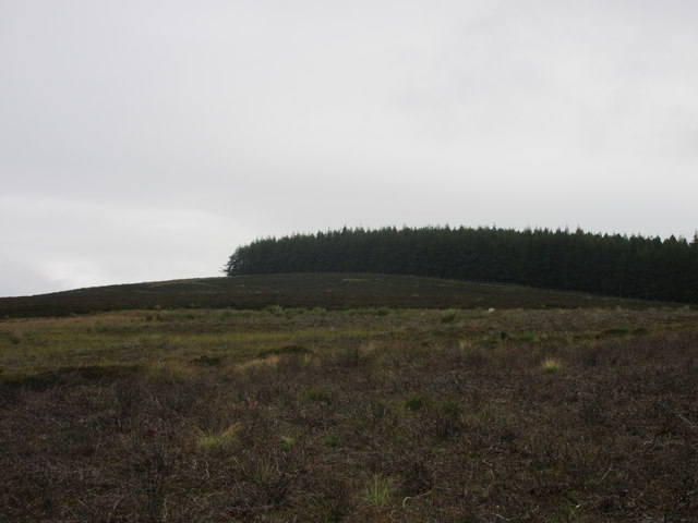
Broom Hill is a modest hill located in Angus, Scotland. Situated near the village of Aberlemno, it offers stunning panoramic views of the surrounding countryside. Although not particularly tall, with an elevation of approximately 200 meters (656 feet), Broom Hill stands out due to its distinctive shape and lush vegetation.

Covered in heather, gorse, and various wildflowers, Broom Hill is a haven for nature enthusiasts. Its slopes are home to a diverse range of flora and fauna, including rabbits, hares, and a variety of bird species. During the spring and summer months, the hill is ablaze with the vibrant colors of blooming flowers, creating a picturesque scene.

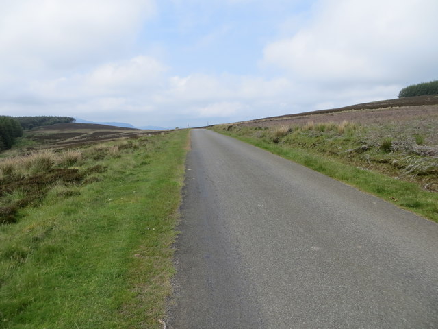
The hill is easily accessible via a well-marked path that winds its way up to the summit. The hike to the top is relatively moderate, making it suitable for individuals of all fitness levels. As walkers ascend, they are rewarded with breathtaking vistas of the Angus countryside, stretching as far as the eye can see.

At the summit of Broom Hill, a trig point marks the highest point, providing a reference point for visitors. On clear days, it is possible to see the distant peaks of the Cairngorms National Park to the north. The hill's location also makes it an excellent spot for stargazing, with minimal light pollution and clear skies offering a glimpse into the wonders of the universe.

Overall, Broom Hill is a charming and accessible destination, offering a delightful escape into the natural beauty of the Angus region.

If you have any feedback on the listing, please let us know in the comments section below.

Broom Hill Images

Images are sourced within 2km of 56.699954/-3.2695814 or Grid Reference NO2257. Thanks to Geograph Open Source API. All images are credited.

Small loch A gravel path leads from the minor road over Kilry Hill to Islaview Cottage. This lochan is about halfway on this path. The Cateran Trail cuts over this track at this point, although it is difficult to discern what exactly it is doing around here.
Small loch
A gravel path leads from the minor road over Kilry Hill to Islaview Cottage. This lochan is about halfway on this path. The Cateran Trail cuts over this track at this point, although it is difficult to discern what exactly it is doing around here.
Cairn set on heather at summit of Druim Dearg Druim Dearg is a minor hill on the south side of Glen Isla. A fence crosses the summit to the south of which is a coniferous plantation and, immediately to the right of the cairn, a telecoms mast - out of view of course.
Cairn set on heather at summit of Druim Dearg
Druim Dearg is a minor hill on the south side of Glen Isla. A fence crosses the summit to the south of which is a coniferous plantation and, immediately to the right of the cairn, a telecoms mast - out of view of course.
Road over the moors And down the glen of the Burn of Kilry to Bridge of Craigisla.
Road over the moors
And down the glen of the Burn of Kilry to Bridge of Craigisla.
Slumping beside the Burn of Kilry After prolonged heavy rain.
Slumping beside the Burn of Kilry
After prolonged heavy rain.
The track to Over Drumhead A wind turbine on Balduff Hill on the left.
The track to Over Drumhead
A wind turbine on Balduff Hill on the left.
Druim Dearg Looking to the partly forested summit of Druim Dearg.
Druim Dearg
Looking to the partly forested summit of Druim Dearg.
Druim Dearg Road Looking northwards up the Druim Dearg road towards its summit.
Druim Dearg Road
Looking northwards up the Druim Dearg road towards its summit.
Hill of Fernyhirst The Hill of Fernyhirst viewed from the Druim Dearg road to the east.
Hill of Fernyhirst
The Hill of Fernyhirst viewed from the Druim Dearg road to the east.
Little Kilry Little Kilry farm, viewed from the north with Balduff Hill beyond.
Little Kilry
Little Kilry farm, viewed from the north with Balduff Hill beyond.
Dalkilry House Dilapidated house at Dalkilry, viewed from the south.
Dalkilry House
Dilapidated house at Dalkilry, viewed from the south.
Cateran Trail heading north The Cateran Trail heading northwards through woodland between Kilry and the Kirkton of Glenisla.
Cateran Trail heading north
The Cateran Trail heading northwards through woodland between Kilry and the Kirkton of Glenisla.
Broom Hill woodland Mixed woodland at the eastern foot of Broom Hill.
Broom Hill woodland
Mixed woodland at the eastern foot of Broom Hill.
River Isla from high ground to the west A distant view of a loop in the River Isla from high up near the Cateran Trail to the west.
River Isla from high ground to the west
A distant view of a loop in the River Isla from high up near the Cateran Trail to the west.
Easter Cammock Easter Cammock farm, viewed from the north on the Cateran Trail.
Easter Cammock
Easter Cammock farm, viewed from the north on the Cateran Trail.
Cateran Trail at Cammock The Cateran Trail heading southwards between the Kirkton of Glenisla and Kilry at Cammock.
Cateran Trail at Cammock
The Cateran Trail heading southwards between the Kirkton of Glenisla and Kilry at Cammock.
Moorland track heading into forestry to the south of Druim Dearg Looking south-eastward.
Moorland track heading into forestry to the south of Druim Dearg
Looking south-eastward.
Minor road climbing up the flank of Druim Dearg Looking north-westward.
Minor road climbing up the flank of Druim Dearg
Looking north-westward.
Moorland track and forest near Druim Dearg Looking south-westward.
Moorland track and forest near Druim Dearg
Looking south-westward.
Show me another place!

Broom Hill is located at Grid Ref: NO2257 (Lat: 56.699954, Lng: -3.2695814)

Unitary Authority: Angus

Police Authority: Tayside

What 3 Words

///catchers.hoot.ferrets. Near Alyth, Perth & Kinross

Nearby Locations

Broom Hill

Related Wikis

Kilry Glen

Kilry Glen, in Angus, Scotland, is the glen of the Burn of Kilry, a tributary of the River Isla. It is situated west of the B954 road, approximately four...

Knockshannoch Lodge

Knockshannoch Lodge is a Category B listed building in the Scottish village of Glenisla, Angus, built around 1888. It is a small, single-storey cottage...

Kirkton of Glenisla

Kirkton of Glenisla consists of a church and graveyard, a hotel, hall and several homes forming the largest concentration of habitation in Glenisla, Angus...

Backwater Reservoir

Backwater Reservoir is a reservoir in north west Angus, Scotland. The reservoir's sole purpose is to provide drinking water, and as such, it supplies Angus...

Auchinleish

Auchinleish is a village in Angus, Scotland. == References ==

Bridge of Craigisla

Bridge of Craigisla is a hamlet in Angus, Scotland. The bridge crosses the River Isla. This settlement lies along the B954 road. == References ==

Brewlands Bridge

Brewlands Bridge is a hamlet in Glen Isla, Angus, Scotland. It is lies situated on the River Isla, eleven miles north-west of Kirriemuir and ten miles...

Bamff

Bamff House is the home of the Ramsays of Bamff, and is located within a 1,300-acre (5.3 km2) estate in Perthshire, Scotland. Bamff House began as a fortified...

Nearby Amenities

Located within 500m of 56.699954,-3.2695814
Islaview Cottage
Place: isolated_dwelling
Lat/Long: 56.698208/-3.2627638
Broom Hill
Ele: 370
Natural: peak
Lat/Long: 56.7005982/-3.2710354
Power: pole
Lat/Long: 56.6971033/-3.2632948
Power: pole
Lat/Long: 56.6965202/-3.2642888
The data included in this document is from www.openstreetmap.org. The data is made available under ODbL.

Have you been to Broom Hill?

Leave your review of Broom Hill below (or comments, questions and feedback).