Breac Leathad

Hill, Mountain in Banffshire

Scotland

Breac Leathad

Gap in the fence below Carn Dulack Looking through the gap towards the Braes of Glenlivet.
Gap in the fence below Carn Dulack Credit: Alan O'Dowd

Breac Leathad, located in Banffshire, Scotland, is a picturesque hill/mountain that offers stunning views and a tranquil escape for outdoor enthusiasts. Rising to an elevation of around 700 meters (2300 feet), it is part of the Cairngorms National Park, known for its breathtaking landscapes and rich biodiversity.

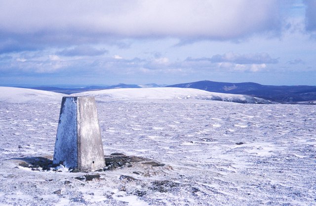
Breac Leathad is characterized by its rugged terrain, featuring rocky slopes, heather-clad moorlands, and scattered patches of woodland. The hill/mountain is primarily composed of granite, which contributes to its distinctive appearance and geological significance. Its summit presents a panoramic vista, allowing visitors to marvel at the surrounding countryside, including the neighboring peaks, valleys, and the sparkling River Spey that meanders through the region.

The area is home to a diverse array of flora and fauna, showcasing the natural beauty of the Scottish Highlands. Walkers and hikers can encounter heather, wildflowers, and various species of birds, such as ptarmigans and golden eagles, as they explore the hill/mountain. Breac Leathad also offers opportunities for wildlife spotting, with red deer, mountain hares, and even elusive Scottish wildcats occasionally seen in the vicinity.

Access to Breac Leathad is generally gained from nearby villages, such as Tomintoul or Ballindalloch, via well-defined paths and trails. It is important for visitors to come prepared with appropriate outdoor gear, as the weather can be unpredictable, especially at higher altitudes. Whether it's a challenging ascent or a leisurely stroll, exploring Breac Leathad promises an unforgettable experience in the heart of Scotland's remarkable natural landscape.

If you have any feedback on the listing, please let us know in the comments section below.

Breac Leathad Images

Images are sourced within 2km of 57.252739/-3.2960113 or Grid Reference NJ2118. Thanks to Geograph Open Source API. All images are credited.

Gap in the fence below Carn Dulack Looking through the gap towards the Braes of Glenlivet.
Gap in the fence below Carn Dulack
Looking through the gap towards the Braes of Glenlivet.
Heather and juniper scrub by the upper Crombie Water Heavily vegetated ground in the Ladder Hills.
Heather and juniper scrub by the upper Crombie Water
Heavily vegetated ground in the Ladder Hills.
Dolines Around Base of Tom Trumper Snow-filled solution dolines (or 'shakeholes') formed upon slopes underlain by Dalradian limestones along the lower slopes of Tom Trumper.  Formed naturally in contrast to a number of nearby grouse-butts.
Dolines Around Base of Tom Trumper
Snow-filled solution dolines (or 'shakeholes') formed upon slopes underlain by Dalradian limestones along the lower slopes of Tom Trumper. Formed naturally in contrast to a number of nearby grouse-butts.
Reservoir at Glenmulliach Forest. Reservoir at Glenmulliach Forest, on the Glenlivet Estate. This is a small reservoir at the point where the forest gives way to moorland. It was built for use by helicopters during forest fires.
Reservoir at Glenmulliach Forest.
Reservoir at Glenmulliach Forest, on the Glenlivet Estate. This is a small reservoir at the point where the forest gives way to moorland. It was built for use by helicopters during forest fires.
From the View Point
From the View Point
Track junction in plantation In plantations on Crown Estate north of Glenmullie
Track junction in plantation
In plantations on Crown Estate north of Glenmullie
Northern entrance to plantation North of Glenmulliach on Crown Estate
Northern entrance to plantation
North of Glenmulliach on Crown Estate
Plantations west of Breac Leathad East of the B9008
Plantations west of Breac Leathad
East of the B9008
Track to mast on Breac Leathad On moorland east of Tomintoul
Track to mast on Breac Leathad
On moorland east of Tomintoul
Communications mast, Breac Leathad On moorland east of Tomintoul
Communications mast, Breac Leathad
On moorland east of Tomintoul
Old & new fencing, Breac Leathad Deer fencing replacing old sheep fencing on Crown Estate
Old & new fencing, Breac Leathad
Deer fencing replacing old sheep fencing on Crown Estate
Pool in course of feeder of Luachair Bhan
Peat hagg now occupied by grasses and mosses south-west of Tom Trumper Perhaps increased drainage has led to this change to the hydrography.
Peat hagg now occupied by grasses and mosses south-west of Tom Trumper
Perhaps increased drainage has led to this change to the hydrography.
Mossy sump upstream of pool south-west of Tom Trumper
Burn course downstream of pool south-west of Tom Trumper The burn courses contain moss rather than purely water.
Burn course downstream of pool south-west of Tom Trumper
The burn courses contain moss rather than purely water.
Peaty banking of Luachair Bhan feeder looking towards outlier of Carn Liath
Upper reaches of Allt nan Seileach near Lynavoir on Conglass Water
Dead bird of prey on moor north-west of Carn Dulack The feathers all around suggest a strike by another bird or perhaps just the consequences of de-composition/re-cycling.
Dead bird of prey on moor north-west of Carn Dulack
The feathers all around suggest a strike by another bird or perhaps just the consequences of de-composition/re-cycling.
Show me another place!

Breac Leathad is located at Grid Ref: NJ2118 (Lat: 57.252739, Lng: -3.2960113)

Unitary Authority: Moray

Police Authority: North East

What 3 Words

///vocals.organ.condensed. Near Grantown-on-Spey, Highland

Nearby Locations

Breac Leathad

Related Wikis

West Aberdeenshire and Kincardine (UK Parliament constituency)

West Aberdeenshire and Kincardine is a county constituency of the House of Commons of the Parliament of the United Kingdom of Great Britain and Northern...

Scalan

The Scalan was once a seminary and was one of the few places in Scotland where the Roman Catholic faith was kept alive during the troubled times of the...

Braeval distillery

Braeval distillery is a distiller of Scotch whisky in Chapeltown, Banffshire, Scotland. Founded in 1973 as Braes of Glenlivet, the distillery is owned...

Clashnoir

Clashnoir is a settlement in Glenlivet, Moray, Scotland, 92 miles north of Edinburgh and 25 miles south of Elgin.

Glenlivet Estate

The Glenlivet Estate is located in Glenlivet, Scotland in the Cairngorms National Park. It measures 58,000 acres (230 km2) and is part of The Crown Estate...

Auchnarrow

Auchnarrow (Scottish Gaelic: Achadh an Arbha) is a village in Moray, Scotland.

Càrn Mòr (Ladder Hills)

Càrn Mòr (804 m) is the highest mountain of the Ladder Hills on the border of Aberdeenshire and Moray, Scotland. It is located northeast of the Cairngorm...

Ladder Hills

The Ladder Hills (Scottish Gaelic: Monadh an Fhàraidh) are a range of hills in northeast Scotland which straddle the border between Aberdeenshire and Moray...

Nearby Amenities

Located within 500m of 57.252739,-3.2960113
Ele: 588
Natural: peak
Lat/Long: 57.2524076/-3.2976193
The data included in this document is from www.openstreetmap.org. The data is made available under ODbL.

Have you been to Breac Leathad?

Leave your review of Breac Leathad below (or comments, questions and feedback).