Broad Crag

Hill, Mountain in Cumberland Copeland

England

Broad Crag

Looking across Hollow Stones to Scafell Crag
Looking across Hollow Stones to Scafell Crag Credit: David Medcalf

Broad Crag is a prominent hill/mountain located in the Lake District National Park, in the county of Cumbria, England. It forms part of the Scafell Pike massif and is situated in the Southern Fells range. With an elevation of 934 meters (3,064 feet), it is the seventh highest peak in England.

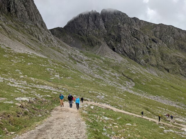
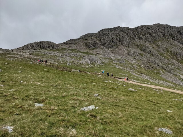
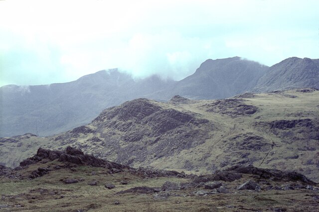
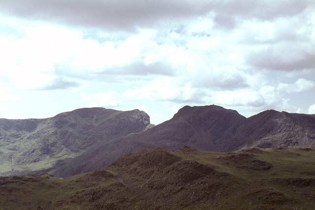
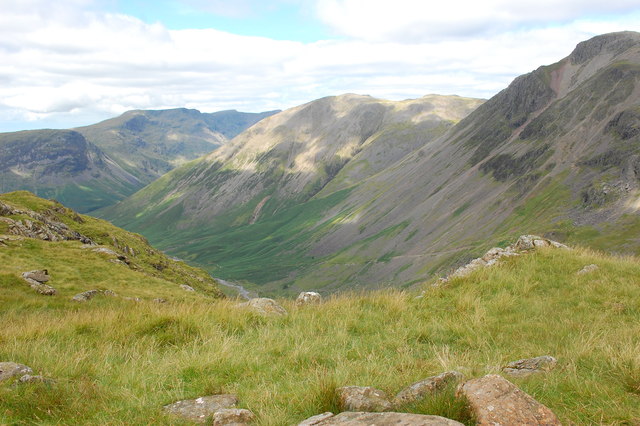
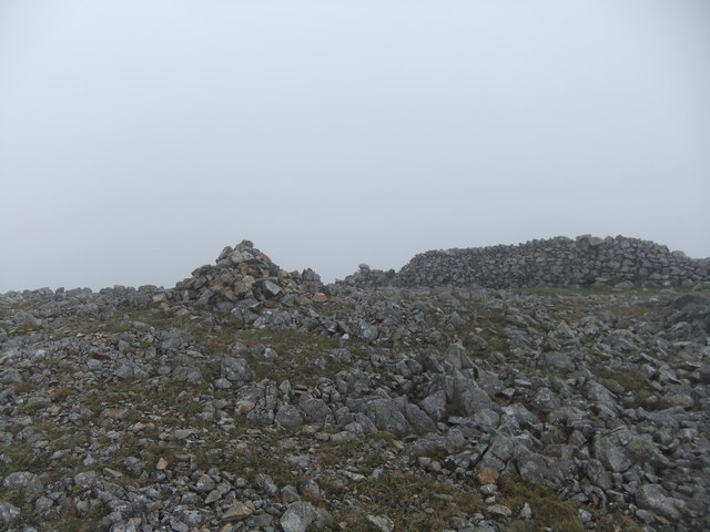
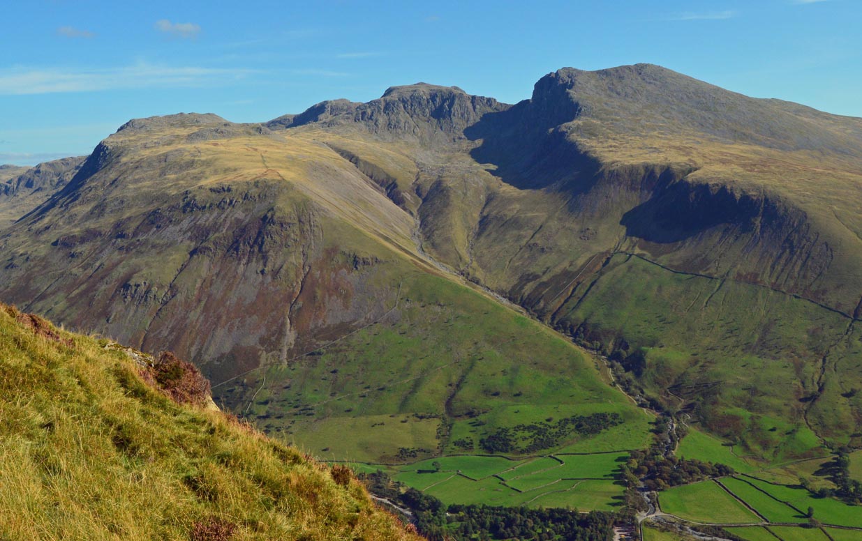
Broad Crag is a rocky and rugged summit characterized by its steep slopes and craggy outcrops. The terrain comprises a mixture of loose scree, boulders, and exposed rock faces, making it a challenging yet rewarding ascent for experienced hikers and mountaineers. It offers stunning panoramic views of the surrounding Lake District landscape, including the nearby peaks of Scafell Pike to the northeast and Ill Crag to the southwest.

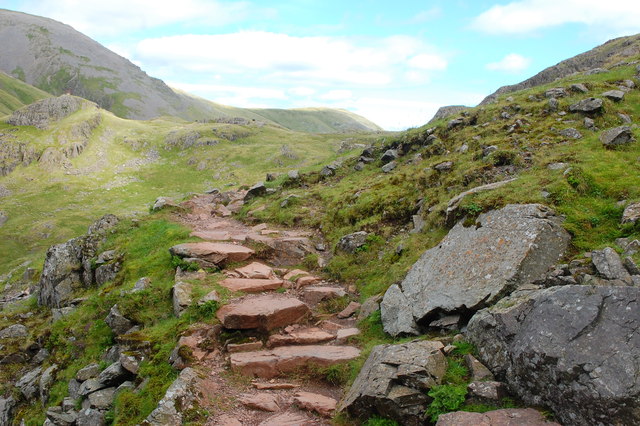
The mountain is often approached from Wasdale Head, a popular starting point for climbers aiming to conquer the highest peaks in England. The most common route involves hiking up the steep scree slopes of Brown Tongue, followed by a scramble over the rocky terrain of Mickledore ridge. From there, a short detour leads to the summit of Broad Crag.

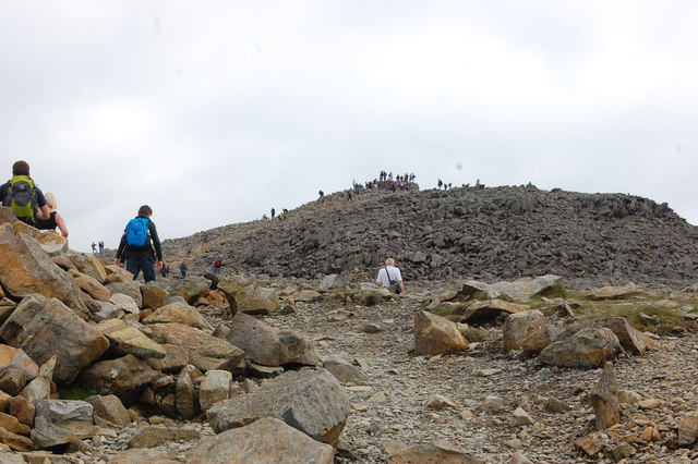
Given its proximity to Scafell Pike, many hikers choose to include Broad Crag as part of a larger circuit or traverse of the area, taking in multiple peaks during their journey. Despite its challenging nature, Broad Crag attracts a steady stream of visitors throughout the year, drawn by the allure of conquering one of England's highest mountains and enjoying the breathtaking beauty of the Lake District.

If you have any feedback on the listing, please let us know in the comments section below.

Broad Crag Images

Images are sourced within 2km of 54.457316/-3.2068579 or Grid Reference NY2107. Thanks to Geograph Open Source API. All images are credited.

Looking across Hollow Stones to Scafell Crag
Looking towards Pikes Crag
Ruddy Gill Ruddy Gill about to enter its gorge which is on the eastern side of Sprinkling Tarn. To the right slopes rise towards Allen Crags, Glaramara is distant at the centre.
Ruddy Gill
Ruddy Gill about to enter its gorge which is on the eastern side of Sprinkling Tarn. To the right slopes rise towards Allen Crags, Glaramara is distant at the centre.
Symonds Knott from the summit of Scafell The view is taken from the summit with Symonds Knott being the rise in the ridge and with Great Gable in the background. With thanks to Ian Taylor for pinpointing the camera position.
Symonds Knott from the summit of Scafell
The view is taken from the summit with Symonds Knott being the rise in the ridge and with Great Gable in the background. With thanks to Ian Taylor for pinpointing the camera position.
The Scafell range from Bow Fell The grassy hill in the middle distance is Pike de Bield. On the skyline are Sca Fell (in cloud), the gap at Mickledore, and Scafell Pike (clear), with Ill Crag on the right.
The Scafell range from Bow Fell
The grassy hill in the middle distance is Pike de Bield. On the skyline are Sca Fell (in cloud), the gap at Mickledore, and Scafell Pike (clear), with Ill Crag on the right.
The Scafells from Bow Fell north ridge In the foreground is the flattish top of the minor hill Pike de Bield. Along the horizon the Scafells stand proud. From left to right we have Sca Fell, Symonds Knott (a fairly modest top but overlooking the sheer drop of Broad Stand), Mickledore (the sharp dip between the two main hills) and Scafell Pike itself. The cairn on this summit, the highest in England at 978m, is clearly seen from 4km away.

Further to the right is Ill Crag. The 'subject' grid ref is for Symonds Knott.
The Scafells from Bow Fell north ridge
In the foreground is the flattish top of the minor hill Pike de Bield. Along the horizon the Scafells stand proud. From left to right we have Sca Fell, Symonds Knott (a fairly modest top but overlooking the sheer drop of Broad Stand), Mickledore (the sharp dip between the two main hills) and Scafell Pike itself. The cairn on this summit, the highest in England at 978m, is clearly seen from 4km away. Further to the right is Ill Crag. The 'subject' grid ref is for Symonds Knott.
On the Corridor Route Looking back towards Sty Head with the slopes of Green Gable beyond.
On the Corridor Route
Looking back towards Sty Head with the slopes of Green Gable beyond.
Sty Head from the Breast Route Looking back down on Sty Head while ascending Great Gable by the Breast Route. The path to Sprinkling Tarn is ahead centre.
Sty Head from the Breast Route
Looking back down on Sty Head while ascending Great Gable by the Breast Route. The path to Sprinkling Tarn is ahead centre.
View into Wasdale From the Corridor Route to Scafell Pike, looking down into upper Wasdale with Great Gable to the right.
View into Wasdale
From the Corridor Route to Scafell Pike, looking down into upper Wasdale with Great Gable to the right.
Scafell Pike Approaching the summit having climbed by the Corridor Route via Lingmell Col. Across the boulder field the summit is ahead.
Scafell Pike
Approaching the summit having climbed by the Corridor Route via Lingmell Col. Across the boulder field the summit is ahead.
On Toad How The Moses' Trod path crosses another scree patch above Toad How, on the southern side of Great Gable. Ahead, the crags of Spout Head are split by the deep Skew Gill.
On Toad How
The Moses' Trod path crosses another scree patch above Toad How, on the southern side of Great Gable. Ahead, the crags of Spout Head are split by the deep Skew Gill.
On a faint path below Spout Head Marked as a path on some scales of the map, and even as a bridleway a little further downhill, this track is well cairned but little used.
On a faint path below Spout Head
Marked as a path on some scales of the map, and even as a bridleway a little further downhill, this track is well cairned but little used.
Well-built path Deep in the valley below Moses' Trod, another path exists too - this well engineered track finds its way up the southern bank of Spouthead Gill.
Well-built path
Deep in the valley below Moses' Trod, another path exists too - this well engineered track finds its way up the southern bank of Spouthead Gill.
Boulders, one perched The location is the ground between Lingmell and Scafell Pike. Seatallan is the far off peak. The complex of nuclear industries at Sellafield is seen more distantly just left of the perched boulder.
Boulders, one perched
The location is the ground between Lingmell and Scafell Pike. Seatallan is the far off peak. The complex of nuclear industries at Sellafield is seen more distantly just left of the perched boulder.
Boulderfield at northern end of Ill Crag One of the main paths to and from Scafell Pike passes between two satellite tops of the mountain, Broad Crag and Ill Crag. Boulders abound everywhere; those seen here are close to the path as it passes north of Ill Crag. Esk Pike and Bow Fell are the two mountains beyond the boulders.
Boulderfield at northern end of Ill Crag
One of the main paths to and from Scafell Pike passes between two satellite tops of the mountain, Broad Crag and Ill Crag. Boulders abound everywhere; those seen here are close to the path as it passes north of Ill Crag. Esk Pike and Bow Fell are the two mountains beyond the boulders.
Rocks embedded in grass The location is below the north face of Great End and north-west of Esk Hause.
Great Gable and Green Gable are in the distance.
Rocks embedded in grass
The location is below the north face of Great End and north-west of Esk Hause. Great Gable and Green Gable are in the distance.
Cairn on SW top of Lingmell
Small tarn by Round How
Show me another place!

Broad Crag is located at Grid Ref: NY2107 (Lat: 54.457316, Lng: -3.2068579)

Administrative County: Cumbria

District: Copeland

Police Authority: Cumbria

What 3 Words

///wheat.rating.jump. Near Ambleside, Cumbria

Nearby Locations

Scafell Pike Broad Crag

Related Wikis

Broad Crag

Broad Crag is a fell in the English Lake District. It is the fifth-highest peak in England at a height of 3,064 feet (934 metres). The mountain was gifted...

Scafell Pike

Scafell Pike () is the highest and the most prominent mountain in England, at an elevation of 978 metres (3,209 ft) above sea level. It is located in the...

Ill Crag

Ill Crag is a fell in the English Lake District. At 935 metres (3,068 ft), it is the fourth-highest peak in England, after Scafell Pike, Sca Fell, and...

Mickledore

Mickledore (the name means great door or pass) is a narrow ridge, 840 metres (2755 ft) high, connecting the mountains of Scafell and Scafell Pike in the...

Nearby Amenities

Located within 500m of 54.457316,-3.2068579
Scafell Pike
Ele: 978
Name Ar: جبل سكافل بيك
Name Arz: جبل سكافيل پيك
Name Az: Skofel Payk
Name Br: Scafell Pike
Name Ca: Scafell Pike
Name Ceb: Scafell Pike
Name Cs: Scafell Pike
Name Cy: Scafell Pike
Name De: Scafell Pike
Name En: Scafell Pike
Name Es: Scafell Pike
Name Eu: Scafell Pike
Name Fi: Scafell Pike
Name Fr: Scafell Pike
Name Ga: Scafell Pike
Name Hy: Սքոֆել-Պայկ
Name Is: Scafell Pike
Name It: Scafell Pike
Name Kk: Скофелл-Пайк
Name Nl: Scafell Pike
Name No: Scafell Pike
Name Pl: Scafell Pike
Name Pnb: سکیفل پائیک
Name Pt: Scafell Pike
Name Ru: Скофелл-Пайк
Name Sh: Scafell Pike
Name Sv: Scafell Pike
Name Sw: Scafell Pike
Name Tr: Scafell Pike
Name Zh: 斯科費爾峰
Natural: peak
Prominence: 912
Tourism: viewpoint
Wikidata: Q1146222
Wikipedia: en:Scafell Pike
Lat/Long: 54.4542192/-3.2115266
Broad Crag
Ele: 934
Natural: peak
Source: NPE
Wikidata: Q4971863
Wikipedia: en:Broad Crag
Lat/Long: 54.4577577/-3.2065517
Ill Crag
Ele: 935
Natural: peak
Source: OS 1:25k
Wikidata: Q5998650
Wikipedia: en:Ill Crag
Lat/Long: 54.4556382/-3.1997562
Green Crag
Place: locality
Lat/Long: 54.4560764/-3.2070139
De Havilland Dominie X7394 Crash Site
Historic: yes
Lat/Long: 54.4593727/-3.2085834
Broad Crag Col
Ele: 878
Mountain Pass: yes
Natural: saddle
Lat/Long: 54.4562335/-3.208942
Sca Fell
Description: OS trig pillar
Ele: 977.5
Man Made: survey_point
Note: Accurate location import for imagery offset calibration. Please do not move. The trig pillar is correctly called Sca Fell despite being beside the Scafell Pike summit. See https://trigpointing.uk/trig/5828.
Ref: S1537
Source: Ordnance Survey (OGL)
Survey Point Structure: pillar
Lat/Long: 54.4542626/-3.2116757
The data included in this document is from www.openstreetmap.org. The data is made available under ODbL.

Have you been to Broad Crag?

Leave your review of Broad Crag below (or comments, questions and feedback).