Capelaw Hill

Hill, Mountain in Midlothian

Scotland

Capelaw Hill

Clochmead path between Harlaw and Glencorse A thin covering snow on the moorland below the Pentland Hills.
Clochmead path between Harlaw and Glencorse Credit: Alan O'Dowd

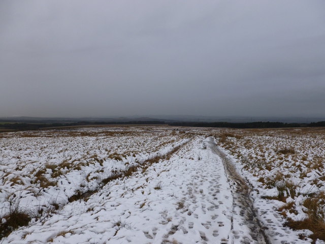
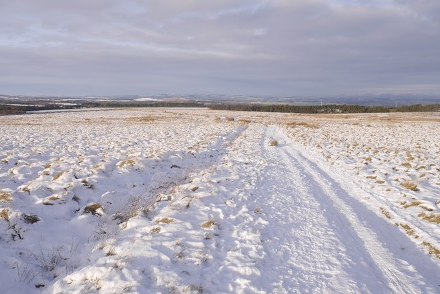
Capelaw Hill is a prominent hill located in Midlothian, Scotland. Standing at an elevation of 454 meters (1,490 feet), it offers breathtaking panoramic views of the surrounding countryside and cityscape. The hill is part of the Pentland Hills range and is a popular destination for hikers, walkers, and nature enthusiasts.

Capelaw Hill is characterized by its rugged terrain, with rocky outcrops and heather-covered slopes. The hill is home to a variety of wildlife, including red deer, birds of prey, and wildflowers. The diverse ecosystem provides a unique opportunity for visitors to observe and appreciate the natural beauty of the area.

The summit of Capelaw Hill is marked by a trig point, which serves as a reference point for surveying and navigation. On a clear day, visitors can see as far as the Firth of Forth and the city of Edinburgh from the top of the hill.

Overall, Capelaw Hill is a stunning natural landmark that offers a peaceful retreat from the hustle and bustle of city life. Whether you're looking for a challenging hike or a leisurely stroll, this hill has something to offer for everyone.

If you have any feedback on the listing, please let us know in the comments section below.

Capelaw Hill Images

Images are sourced within 2km of 55.880469/-3.254511 or Grid Reference NT2165. Thanks to Geograph Open Source API. All images are credited.

Clochmead path between Harlaw and Glencorse A thin covering snow on the moorland below the Pentland Hills.
Clochmead path between Harlaw and Glencorse
A thin covering snow on the moorland below the Pentland Hills.
Clubbiedean Reservoir Inflow at the western end of the reservoir
Clubbiedean Reservoir
Inflow at the western end of the reservoir
Clubbiedean Reservoir A small reservoir opened in 1850, dammed at its NE end, and now managed as a trout fishery. It lies within the Bonaly Country Park.
Clubbiedean Reservoir
A small reservoir opened in 1850, dammed at its NE end, and now managed as a trout fishery. It lies within the Bonaly Country Park.
Clubbiedean Hillfort Earthworks This is a scheduled monument and those in the know seem to agree that it is the remains of an Iron Age, or late prehistoric (as the Iron Age sometimes gets called) hillfort. It is fairly unusual for being quite so visible at ground level - a lot of these old sites marked on maps are very hard to distinguish from their surroundings when you get there. Drones are the best way to see them properly I have been told.
The official Historic Scotland write-up is very poorly written and the depiction on the map is a bit confusing (to me anyway, maybe I don't quite get the triangles they use!), but after reading a few descriptions from various sources it seems that there was an inner and outer wall originally, which can plainly he seen here. The picture was taken from the small wood on the South side of Clubbiedean Reservoir - the map shows banks and ditches inside the wood but my untrained eye didn't spot anything obvious.
The Iron Age was quite long, from 800BC to 43AD, when the Romans took over. But not as long, strangely, as the mediaeval period, which went from about 400 to 1450.
Clubbiedean Hillfort Earthworks
This is a scheduled monument and those in the know seem to agree that it is the remains of an Iron Age, or late prehistoric (as the Iron Age sometimes gets called) hillfort. It is fairly unusual for being quite so visible at ground level - a lot of these old sites marked on maps are very hard to distinguish from their surroundings when you get there. Drones are the best way to see them properly I have been told. The official Historic Scotland write-up is very poorly written and the depiction on the map is a bit confusing (to me anyway, maybe I don't quite get the triangles they use!), but after reading a few descriptions from various sources it seems that there was an inner and outer wall originally, which can plainly he seen here. The picture was taken from the small wood on the South side of Clubbiedean Reservoir - the map shows banks and ditches inside the wood but my untrained eye didn't spot anything obvious. The Iron Age was quite long, from 800BC to 43AD, when the Romans took over. But not as long, strangely, as the mediaeval period, which went from about 400 to 1450.
Clubbiedean Reservoir One of the earlier Edinburgh reservoirs.
Clubbiedean Reservoir
One of the earlier Edinburgh reservoirs.
Pasture near Clubbiedean The distant woodland surrounds Bonally Reservoir.
Pasture near Clubbiedean
The distant woodland surrounds Bonally Reservoir.
Heading to Glencorse via Maiden's Cleugh There's an extensive network of paths in this area
Heading to Glencorse via Maiden's Cleugh
There's an extensive network of paths in this area
West end of Clubbiedean Reservoir
Road, Clubbiedean Reservoir Road running from Torduff to Easter Kinleith passing the west end of the reservoir.
Road, Clubbiedean Reservoir
Road running from Torduff to Easter Kinleith passing the west end of the reservoir.
Swan on Clubbidean Reservoir Looking from the track that goes from Torduff to Easter Kinleith.
Swan on Clubbidean Reservoir
Looking from the track that goes from Torduff to Easter Kinleith.
The fort at Clubbiedean reservoir. Grass embankments and ditched enclosure. They stretch in a semi-circle from the edged of the burn on the East side round to a dip where a burn used to be on the West. Backing onto a steep slope above the reservoir. Which should have been a deep burn at the time.
The fort at Clubbiedean reservoir.
Grass embankments and ditched enclosure. They stretch in a semi-circle from the edged of the burn on the East side round to a dip where a burn used to be on the West. Backing onto a steep slope above the reservoir. Which should have been a deep burn at the time.
Interior of Clubbiedean fort. Inside the ditches at Clubbiedean. Possible entrance or just a gap in the bank.
Interior of Clubbiedean fort.
Inside the ditches at Clubbiedean. Possible entrance or just a gap in the bank.
Maiden's Cleugh track View towards Harlaw on the crossing to Glencorse.
Maiden's Cleugh track
View towards Harlaw on the crossing to Glencorse.
Clubbiedean Reservoir The head of the reservoir is fed by a small artificial cascade, though the supply of water leading to the cascade must be underground as there is no evidence of a burn. The speckles on the water surface are leaves of water plants, but not waterlilies which have circular leaves. .
Clubbiedean Reservoir
The head of the reservoir is fed by a small artificial cascade, though the supply of water leading to the cascade must be underground as there is no evidence of a burn. The speckles on the water surface are leaves of water plants, but not waterlilies which have circular leaves. .
Clubbiedean Reservoir This is the long narrow western end of the reservoir, furthest from the dam.
Clubbiedean Reservoir
This is the long narrow western end of the reservoir, furthest from the dam.
Grazing Land at Clubbiedean The land slopes up here towards Bonaly Reservoir, which is beyond the trees on the left skyline.
Grazing Land at Clubbiedean
The land slopes up here towards Bonaly Reservoir, which is beyond the trees on the left skyline.
Clubbiedean Reservoir The upper end of the reservoir from the rough path round the south side.
Clubbiedean Reservoir
The upper end of the reservoir from the rough path round the south side.
Fisherman on Clubbiedean Reservoir This angler was rowing round the reservoir towing his line behind the boat.
Fisherman on Clubbiedean Reservoir
This angler was rowing round the reservoir towing his line behind the boat.
Show me another place!

Capelaw Hill is located at Grid Ref: NT2165 (Lat: 55.880469, Lng: -3.254511)

Unitary Authority: City of Edinburgh

Police Authority: Edinburgh

What 3 Words

///rapid.paints.scare. Near Colinton, Edinburgh

Related Wikis

Bonaly

Bonaly () is an area on the south-western outskirts of Edinburgh and the northern slopes of the Pentland Hills, lying within the Parish of Colinton. It...

Caerketton Hill

Caerketton Hill is a hill in the Pentland Hills range of Scotland. Standing at 478 m, it is at the northeast end of the approximately 25 km (16 mi) long...

Glencorse Reservoir

Glencorse Reservoir is a reservoir in Midlothian, Scotland, two miles west of Glencorse, in the Pentland Hills. It is retained by an earth dam, and it...

Torphin

Torphin ( tor-FIN) is a small area in the south-west of Edinburgh, Scotland, with its name deriving from the nearby Torphin Hill. It lies just south of...

Nearby Amenities

Located within 500m of 55.880469,-3.254511
Capelaw Hill
Ele: 454
Natural: peak
Wikidata: Q20190378
Lat/Long: 55.8803945/-3.2546213
Landmark: pillar
Lat/Long: 55.8802038/-3.2547566
The data included in this document is from www.openstreetmap.org. The data is made available under ODbL.

Have you been to Capelaw Hill?

Leave your review of Capelaw Hill below (or comments, questions and feedback).