Airigh Hill
Hill, Mountain in Caithness
Scotland
Airigh Hill

Airigh Hill, located in the county of Caithness in the north-eastern part of Scotland, is a prominent hill that stands as a striking feature of the region's landscape. Rising to an elevation of approximately 179 meters (587 feet), Airigh Hill offers breathtaking panoramic views of the surrounding countryside.
The hill is characterized by its gently sloping sides, covered in a patchwork of heather, grasses, and scattered shrubs. Its summit presents a relatively flat plateau, making it easily accessible for hikers and nature enthusiasts. The path leading to the top is well-defined and often used by locals and visitors alike.
Airigh Hill is situated within an area of outstanding natural beauty, boasting stunning vistas of the rolling hills, expansive farmland, and the distant coastline. On clear days, the views extend as far as the Orkney Islands, adding to the allure of this picturesque location.
The hill is also renowned for its rich biodiversity, with an abundance of wildlife inhabiting its slopes. Visitors may encounter various species of birds, including kestrels, buzzards, and pheasants. Additionally, the area is home to rabbits, hares, and occasionally, red deer.
Due to its accessibility and captivating scenery, Airigh Hill has become a popular destination for outdoor activities such as walking, hiking, and photography. The peaceful and tranquil ambiance of the hill offers a perfect escape from the hustle and bustle of daily life, allowing visitors to immerse themselves in the natural beauty of Caithness.
If you have any feedback on the listing, please let us know in the comments section below.
Airigh Hill Images
Images are sourced within 2km of 58.324794/-3.3502016 or Grid Reference ND2138. Thanks to Geograph Open Source API. All images are credited.


Airigh Hill is located at Grid Ref: ND2138 (Lat: 58.324794, Lng: -3.3502016)
Unitary Authority: Highland
Police Authority: Highlands and Islands
What 3 Words
///lied.shrubbery.automate. Near Dunbeath, Highland
Nearby Locations
Related Wikis

Rumster Forest transmitting station
The Rumster Forest transmitting station is a broadcasting and telecommunications facility near the town of Wick, in Caithness, Scotland (grid reference...

Upper Lybster
Upper Lybster is a scattered and crofting village, situated 2 miles north of Lybster, in eastern Caithness, Scottish Highlands and is in the Scottish council...

Achavanich
Achavanich ( ak-ə-VAN-ik; Scottish Gaelic: Achadh a’ Mhanaich) is an unusual megalithic horseshoe-shaped structure near Loch Stemster in Caithness, Scotland...
Parkside Halt railway station
Parkside Halt was a railway station located between Ulbster and Lybster, Highland. == History == The station was opened on the Wick and Lybster Railway...
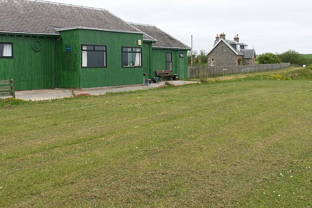
Lybster railway station
Lybster was a railway station located on the Wick and Lybster Railway in the Highland area of Scotland. The station building now serves as the clubhouse...
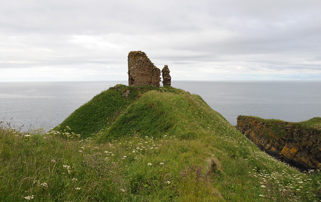
Forse Castle
Forse Castle is a ruined building dating from 1200 in the hamlet of Forse in the Caithness region in the Scottish council area of Highland. It is protected...
Swiney
Swiney is a small village on the east coast of Scotland, 1 mile west of Lybster along the A99 road, in Caithness, Scottish Highlands and is in the Scottish...

Lybster
Lybster (, Scottish Gaelic: Liabost) is a village on the east coast of Caithness in northern Scotland. It was once a big herring fishing port. The Waterlines...
Have you been to Airigh Hill?
Leave your review of Airigh Hill below (or comments, questions and feedback).