Ewe Hill

Hill, Mountain in Peeblesshire

Scotland

Ewe Hill

Old drove road near Romanno Hope This track forms part of the Cross Borders Drove Road, a long-distance walking route between Harperrig, south-west of Edinburgh, and Hawick.
Old drove road near Romanno Hope Credit: Alan O'Dowd

Ewe Hill is a prominent hill located in the Peeblesshire region of Scotland. Situated near the town of Peebles, it forms part of the wider Tweed Valley landscape, which is famed for its natural beauty and scenic views. The hill has an elevation of approximately 456 meters (1,496 feet) and offers panoramic vistas of the surrounding countryside.

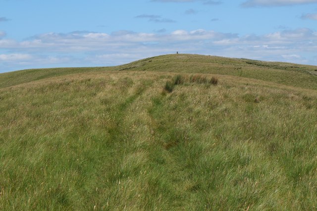
Ewe Hill is known for its distinctive conical shape, covered in heather and grass, which adds to its visual appeal. It is a popular destination for hikers and outdoor enthusiasts, who are drawn to its challenging yet rewarding trails. The ascent to the summit can be steep at times, but the effort is well worth it for the breathtaking views that await.

From the top of Ewe Hill, visitors can enjoy unobstructed vistas of the rolling hills, lush valleys, and meandering rivers that define the Scottish Borders region. On clear days, the views extend as far as the distant hills of the Scottish Highlands.

The area surrounding Ewe Hill is also rich in wildlife, with various bird species, including peregrine falcons and red kites, frequently spotted soaring above. The hill is also home to a variety of plant species, making it a haven for nature enthusiasts and botanists.

Ewe Hill offers a peaceful and tranquil setting, providing a welcome escape from the bustling urban life. Its natural beauty, challenging trails, and awe-inspiring views make it a must-visit destination for those exploring Peeblesshire and the wider Scottish Borders region.

If you have any feedback on the listing, please let us know in the comments section below.
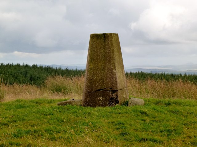
Ewe Hill Images

Images are sourced within 2km of 55.714171/-3.2701061 or Grid Reference NT2047. Thanks to Geograph Open Source API. All images are credited.

Old drove road near Romanno Hope This track forms part of the Cross Borders Drove Road, a long-distance walking route between Harperrig, south-west of Edinburgh, and Hawick.
Old drove road near Romanno Hope
This track forms part of the Cross Borders Drove Road, a long-distance walking route between Harperrig, south-west of Edinburgh, and Hawick.
Ford on the Fingland Burn near Romanno Hope This track forms part of the Cross Borders Drove Road, a long-distance walking route between Harperrig, south-west of Edinburgh, and Hawick.
Ford on the Fingland Burn near Romanno Hope
This track forms part of the Cross Borders Drove Road, a long-distance walking route between Harperrig, south-west of Edinburgh, and Hawick.
Mist rolling over forested hillsides above the Flemington Burn It was a day of stark contrasts between bright winter sunshine and banks of mist.
Mist rolling over forested hillsides above the Flemington Burn
It was a day of stark contrasts between bright winter sunshine and banks of mist.
Sunlight and mist on Hag Law A mixture of low winter sunlight and banks of mist made for some atmospheric conditions.
Sunlight and mist on Hag Law
A mixture of low winter sunlight and banks of mist made for some atmospheric conditions.
Hillwalker in the mist on Wether Law Quite a contrast with the bright winter sunshine down in the valley.
Hillwalker in the mist on Wether Law
Quite a contrast with the bright winter sunshine down in the valley.
Bridge timber by Fingland Burn Before too long it looks as though a footbridge will be built here in Romanno Hope.
Bridge timber by Fingland Burn
Before too long it looks as though a footbridge will be built here in Romanno Hope.
Gate into Cloich Forest On the path from Romannobridge, also on the Cross Borders Drove Road.
Gate into Cloich Forest
On the path from Romannobridge, also on the Cross Borders Drove Road.
Path in Cloich Forest The path from the Flemington Burn to the forest road near Courhope, also part of the Cross Borders Drove Road.
Path in Cloich Forest
The path from the Flemington Burn to the forest road near Courhope, also part of the Cross Borders Drove Road.
Grassfield Hill
Grassfield Hill
Wether Law
Wether Law
Wether Law Revisited to celebrate Colin's 600th Marilyn (second round) "Hall of Mirrors" and Rick Salter's 700th Marilyn, with Colin Crawford, Bernie Hughes, Jenny Hatfield, Rick Salter and Alan Dawson from Newlands Church, via sub-Hump Drum Maw on an initially grey day, improving to good visibility and sunshine. A fine summit party was had due to goods found in Colin's rucksack. Then onto a sub Marilyn and a P30.
Name: Wether Law
Hill number: 1817
Height: 479m / 1572ft
Area: 28A: Firth of Forth to the River Tweed
Class: Ma
Grid ref: NT 19467 48374
Summit feature: trig point
Drop: 212m
Col: 267m  NT252549
Wether Law
Revisited to celebrate Colin's 600th Marilyn (second round) "Hall of Mirrors" and Rick Salter's 700th Marilyn, with Colin Crawford, Bernie Hughes, Jenny Hatfield, Rick Salter and Alan Dawson from Newlands Church, via sub-Hump Drum Maw on an initially grey day, improving to good visibility and sunshine. A fine summit party was had due to goods found in Colin's rucksack. Then onto a sub Marilyn and a P30. Name: Wether Law Hill number: 1817 Height: 479m / 1572ft Area: 28A: Firth of Forth to the River Tweed Class: Ma Grid ref: NT 19467 48374 Summit feature: trig point Drop: 212m Col: 267m NT252549
Wether Law Looking along the summit ridge.
Wether Law
Looking along the summit ridge.
Fingland Cottage under Wether Law.
Fingland
Cottage under Wether Law.
Forest edge, Hare Hope A variety of tree types and ages on the NW side of Crailzie Hill, seen from Green Knowe.
Forest edge, Hare Hope
A variety of tree types and ages on the NW side of Crailzie Hill, seen from Green Knowe.
Gate south of Fingland A gate on the access track to the remote cottage at Fingland with Cloich Forest on the background.
Gate south of Fingland
A gate on the access track to the remote cottage at Fingland with Cloich Forest on the background.
Fingland A remote cottage on the slopes of Hag Law to the west of Cloich Forest.
Fingland
A remote cottage on the slopes of Hag Law to the west of Cloich Forest.
Cloich Forest Open moorland on Hag Law and Wether Law contrast with the dense plantations to the east.
Cloich Forest
Open moorland on Hag Law and Wether Law contrast with the dense plantations to the east.
The summit in view, Wether Law An easy climb on the grassy ridge to the trig point at 479m.
The summit in view, Wether Law
An easy climb on the grassy ridge to the trig point at 479m.
Show me another place!

Ewe Hill is located at Grid Ref: NT2047 (Lat: 55.714171, Lng: -3.2701061)

Unitary Authority: The Scottish Borders

Police Authority: The Lothians and Scottish Borders

What 3 Words

///lighten.lecturers.vision. Near West Linton, Scottish Borders

Nearby Locations

Ewe Hill

Related Wikis

Black Barony

Barony Castle, also and formerly known as Black Barony, and Darnhall, is a historic house at Eddleston in the Scottish Borders area of Scotland. The house...

Great Polish Map of Scotland

The Great Polish Map of Scotland is a large (50 m x 40 m) three-dimensional, outdoor concrete scale model of Scotland, located in the grounds of the Barony...

Darnhall Mains

Darnhall Mains is a farm and settlement off the A703, near Eddleston and the Eddleston Water in the Scottish Borders area of Scotland, in the former Peeblesshire...

Eddleston railway station

Eddleston railway station served the village of Eddleston, Scottish Borders, Scotland from 1855 to 1962 on the Peebles Railway. == History == The station...

Nearby Amenities

Located within 500m of 55.714171,-3.2701061
Ewe Hill
Ele: 462
Natural: peak
Lat/Long: 55.7143324/-3.269933
The data included in this document is from www.openstreetmap.org. The data is made available under ODbL.

Have you been to Ewe Hill?

Leave your review of Ewe Hill below (or comments, questions and feedback).