Hay Stacks

Hill, Mountain in Cumberland Copeland

England

Hay Stacks

A Frosty Dub's Hut in the Sunset This ex-quarry building is now maintained as a basic hiking shelter by volunteers of the Mountain Bothies Association with permission of the landowners.
A Frosty Dub's Hut in the Sunset Credit: Booga

Hay Stacks is a prominent hill located in the Lake District National Park in Cumbria, England. Standing at an elevation of 597 meters (1,958 feet), it is one of the most popular and iconic peaks in the region. It is situated in the western part of the national park, approximately 4 kilometers (2.5 miles) northeast of the village of Buttermere.

The name "Hay Stacks" is thought to have originated from the hay barns that were once situated at the base of the hill. It gained further fame when renowned British author Alfred Wainwright included it in his famous guidebook series, "A Pictorial Guide to the Lakeland Fells." Wainwright described Hay Stacks as a mountain with "a profile that would attract the artist or poet," adding to its allure.

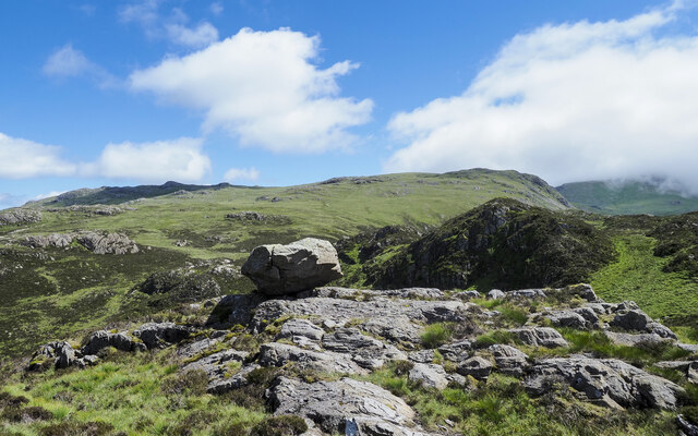
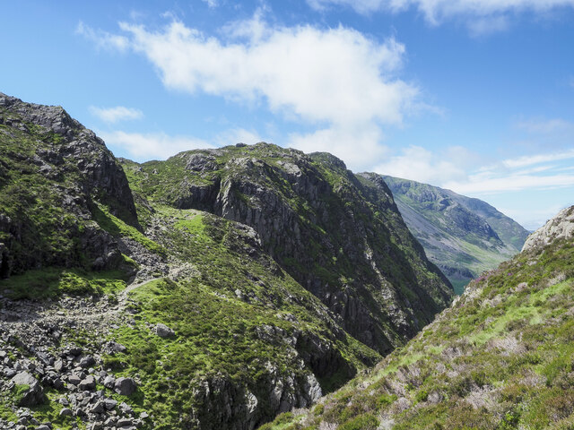
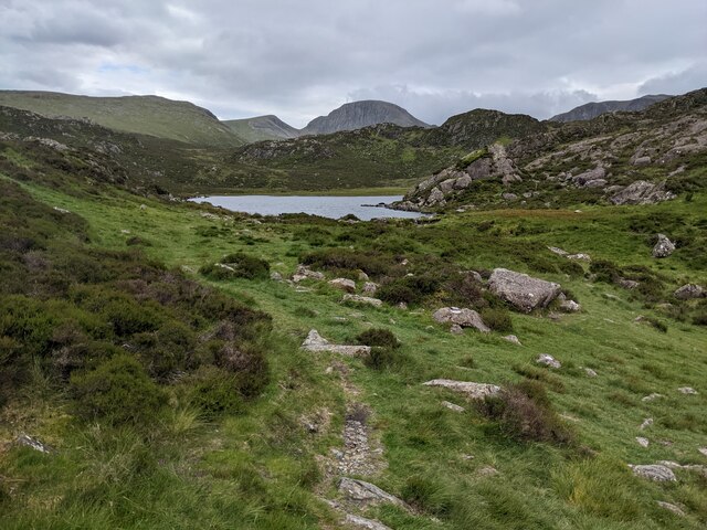
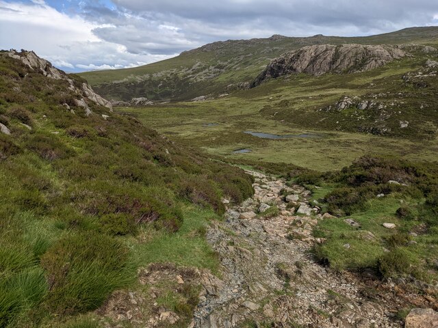
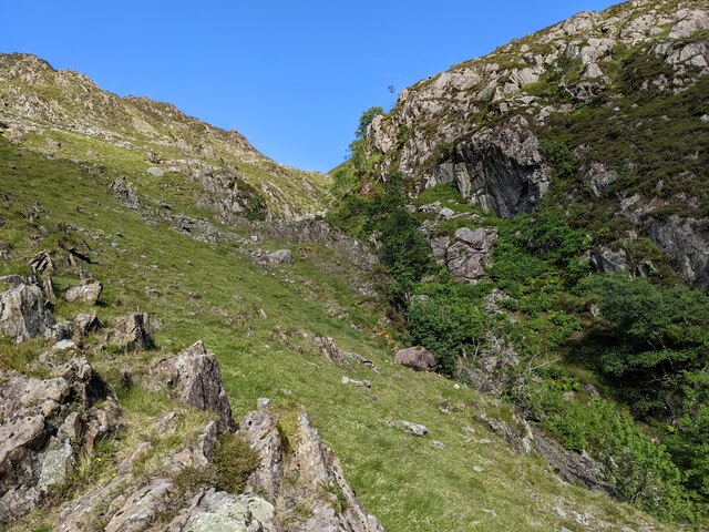
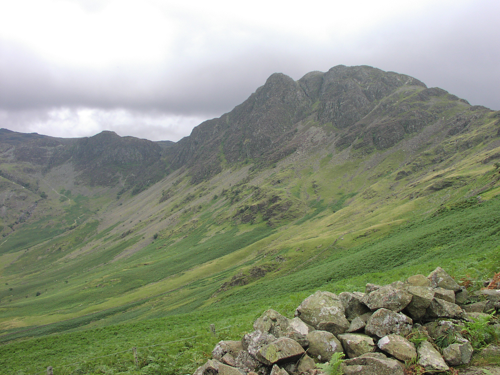
Hay Stacks offers breathtaking panoramic views of the surrounding landscape, including the Buttermere Valley, Crummock Water, and the High Stile range. Its rugged and rocky terrain makes it a popular destination for hikers and walkers, attracting outdoor enthusiasts from all over the world.

The ascent to the summit of Hay Stacks can be challenging, with steep slopes and uneven paths, but the reward is well worth the effort. The summit itself is marked by a small pile of stones, known as a cairn, offering a peaceful spot for visitors to rest and take in the stunning vistas.

Overall, Hay Stacks is a natural gem in the Lake District, offering a picturesque and rewarding experience for those who venture to its summit.

If you have any feedback on the listing, please let us know in the comments section below.

Hay Stacks Images

Images are sourced within 2km of 54.507191/-3.2472948 or Grid Reference NY1913. Thanks to Geograph Open Source API. All images are credited.

A Frosty Dub's Hut in the Sunset This ex-quarry building is now maintained as a basic hiking shelter by volunteers of the Mountain Bothies Association with permission of the landowners.
A Frosty Dub's Hut in the Sunset
This ex-quarry building is now maintained as a basic hiking shelter by volunteers of the Mountain Bothies Association with permission of the landowners.
Warnscale Head Bothy Maintained by volunteers of the Mountain Bothies Association with permission of the landowner. This small hiking shelter is made from local stone and so blends in well with its surroundings.
Warnscale Head Bothy
Maintained by volunteers of the Mountain Bothies Association with permission of the landowner. This small hiking shelter is made from local stone and so blends in well with its surroundings.
Perched boulder on rock slabs The boulder is in rough, complex hill country south of Blackbeck Tarn.
Grey Knotts and Brandreth are two mountain tops on the horizon beyond.
Perched boulder on rock slabs
The boulder is in rough, complex hill country south of Blackbeck Tarn. Grey Knotts and Brandreth are two mountain tops on the horizon beyond.
Path descending to cross cleft between mountains The path on a shelf below crags is descending to cross the stream which issues from Blackbeck Tarn in the cleft before rising again to the camera location. Haystacks is the mountain across the void.
Path descending to cross cleft between mountains
The path on a shelf below crags is descending to cross the stream which issues from Blackbeck Tarn in the cleft before rising again to the camera location. Haystacks is the mountain across the void.
Striddle Crag of Fleetwith Pike The crag is beyond the two walkers along the path which is close to Little Round How.
Striddle Crag of Fleetwith Pike
The crag is beyond the two walkers along the path which is close to Little Round How.
Warnscale Head Bothy, Lake District Lovely bothy with a remarkable view.
Warnscale Head Bothy, Lake District
Lovely bothy with a remarkable view.
Heading for Haystacks from Little Round How
Approaching Haystacks from the East
Blackbeck Tarn
Blackbeck Tarn
Pitched path dropping to Black Beck
Looking up Warnscale Beck That's the far beck, not the one in the foreground which is unnamed.
Looking up Warnscale Beck
That's the far beck, not the one in the foreground which is unnamed.
The path near Blackbeck Tarn With Black Beck in the foreground.
The path near Blackbeck Tarn
With Black Beck in the foreground.
A view of Blackbeck Tarn
Black Beck with Blackbeck Tarn beyond
The rocky path behind Green Crag
The bridleway above Warnscale Beck It's not an appealing bridleway for biking on, but was perhaps used by pack horses heading to or from the quarries above.
The bridleway above Warnscale Beck
It's not an appealing bridleway for biking on, but was perhaps used by pack horses heading to or from the quarries above.
Trees thrive in the sanctuary of Warnscale Beck gorge
The bridleway and a view down Buttermere
Show me another place!

Hay Stacks is located at Grid Ref: NY1913 (Lat: 54.507191, Lng: -3.2472948)

Administrative County: Cumbria

District: Copeland

Police Authority: Cumbria

What 3 Words

///tidal.fewest.dynamics. Near Keswick, Cumbria

Related Wikis

Haystacks (Lake District)

Haystacks, or Hay Stacks, is a hill in England's Lake District, situated at the south-eastern end of the Buttermere Valley. Although not of any great elevation...

Innominate Tarn

Innominate Tarn is a small tarn in the north of the Lake District National Park in England. It is situated at 520 metres above sea level, near the summit...

Seat (Buttermere)

Seat or Seat (Buttermere) is a minor Fell in the English Lake District. It has a height of 561 m (1840 ft). Seat is over-shadowed by Haystacks and High...

Cumbria

Cumbria ( KUM-bree-ə) is a ceremonial county in North West England. It borders the Scottish council areas of Dumfries and Galloway and Scottish Borders...

Cumbrian dialect

Cumbrian dialect or Cumberland dialect is a local dialect of Northern England in decline, spoken in Cumberland, Westmorland and Lancashire North of the...

Blackbeck Tarn

Blackbeck Tarn is a small tarn in Cumbria, England, situated near the summit of Haystacks in the Buttermere Valley. At an elevation of 486 m (1,594 ft...

Fleetwith Pike

Fleetwith Pike is a fell in the English Lake District in the county of Cumbria which reaches a height of 648 metres (2,126 feet). The fell is a well-known...

High Crag

High Crag stands at the southern end of the High Stile ridge which divides the valleys of Ennerdale and Buttermere in the west of the English Lake District...

Nearby Amenities

Located within 500m of 54.507191,-3.2472948
Source: npe
Lat/Long: 54.5051537/-3.2409691
Source: npe
Lat/Long: 54.5053024/-3.2410745
Source: npe
Lat/Long: 54.5055245/-3.2412844
Source: npe
Lat/Long: 54.505811/-3.2411193
Source: npe
Lat/Long: 54.5054834/-3.2403627
Source: npe
Lat/Long: 54.5051763/-3.2407358
Hay Stacks
Alt Name: Haystacks
Ele: 597
Natural: peak
Source: npe
Wikidata: Q5687267
Wikipedia: en:Haystacks (Lake District)
Lat/Long: 54.5072116/-3.2472531
Scarth Gap
Ele: 445
Mountain Pass: yes
Natural: saddle
Lat/Long: 54.5088551/-3.2537595
Great Stack
Place: locality
Lat/Long: 54.5088704/-3.2485847
Warn Ghyll
Place: locality
Lat/Long: 54.5076348/-3.2414835
Stack Ghyll
Place: locality
Lat/Long: 54.5079072/-3.2425785
Stack Rake
Place: locality
Lat/Long: 54.5101708/-3.2472057
The data included in this document is from www.openstreetmap.org. The data is made available under ODbL.

Have you been to Hay Stacks?

Leave your review of Hay Stacks below (or comments, questions and feedback).