Annan Hill

Hill, Mountain in Dumfriesshire

Scotland

Annan Hill

View to Solway Coast
View to Solway Coast Credit: thejackrustles

Annan Hill is a prominent hill located in Dumfriesshire, Scotland. Situated near the town of Annan, the hill stands at an elevation of 165 meters (541 feet) above sea level. It is a popular destination for locals and tourists alike, offering breathtaking panoramic views of the surrounding landscape.

The hill is easily accessible, with well-maintained footpaths leading to the summit. It is a relatively easy climb, suitable for all ages and fitness levels. Along the way, visitors can enjoy the diverse flora and fauna that inhabit the hillside, including heather, gorse, and a variety of bird species.

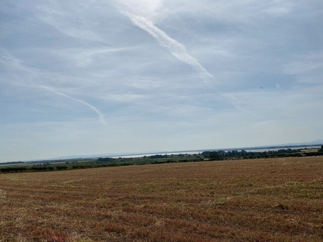
At the top of Annan Hill, visitors are rewarded with stunning vistas that overlook the Solway Firth and the rolling Dumfries and Galloway countryside. On a clear day, it is possible to see as far as the English Lake District and the distant peaks of the Scottish Highlands.

Historically, Annan Hill has played a significant role in the region. It was once home to an Iron Age fort, providing strategic advantages for its inhabitants. Today, remnants of the fort can still be seen, adding a touch of historical intrigue to the hill.

Whether for leisurely walks, birdwatching, or simply enjoying the scenic beauty of the area, Annan Hill offers a peaceful and picturesque retreat. It is a must-visit destination for nature enthusiasts and those seeking a tranquil escape in Dumfriesshire.

If you have any feedback on the listing, please let us know in the comments section below.
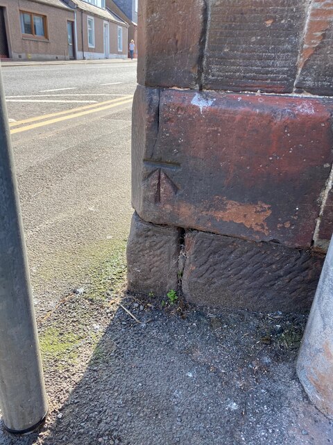
Annan Hill Images

Images are sourced within 2km of 54.977027/-3.2637886 or Grid Reference NY1965. Thanks to Geograph Open Source API. All images are credited.

View to Solway Coast
View of River Annan
View of River Annan
Bridge over River Annan
OS 1GL Bolt: Annan, River Bridge <span class="nowrap"><a title="https://www.bench-marks.org.uk/bm36172" rel="nofollow ugc noopener" href="https://www.bench-marks.org.uk/bm36172">Link</a><img style="margin-left:2px;" alt="External link" title="External link - shift click to open in new window" src="https://s1.geograph.org.uk/img/external.png" width="10" height="10"/></span>
OS 1GL Bolt: Annan, River Bridge
Annan Town Hall
Annan Town Hall
OS Flush Bracket OSBM S7353: Annan, Town Hall <span class="nowrap"><a title="https://www.bench-marks.org.uk/bm21017" rel="nofollow ugc noopener" href="https://www.bench-marks.org.uk/bm21017">Link</a><img style="margin-left:2px;" alt="External link" title="External link - shift click to open in new window" src="https://s1.geograph.org.uk/img/external.png" width="10" height="10"/></span>
OS Flush Bracket OSBM S7353: Annan, Town Hall
Location of Flush Bracket OSBM S7353: Annan, Town Hall <span class="nowrap"><a title="https://www.bench-marks.org.uk/bm21017" rel="nofollow ugc noopener" href="https://www.bench-marks.org.uk/bm21017">Link</a><img style="margin-left:2px;" alt="External link" title="External link - shift click to open in new window" src="https://s1.geograph.org.uk/img/external.png" width="10" height="10"/></span>
Location of Flush Bracket OSBM S7353: Annan, Town Hall
Annan High Street
Annan High Street
Corner of Scotts Street, Annan
OS Cut Mark - Annan, Number 2 Scotts Street <span class="nowrap"><a title="https://www.bench-marks.org.uk/bm61706" rel="nofollow ugc noopener" href="https://www.bench-marks.org.uk/bm61706">Link</a><img style="margin-left:2px;" alt="External link" title="External link - shift click to open in new window" src="https://s1.geograph.org.uk/img/external.png" width="10" height="10"/></span>
OS Cut Mark - Annan, Number 2 Scotts Street
Annan, St Columba's RC Chapel
OS Cut Mark - Annan, St Columba's RC Chapel <span class="nowrap"><a title="https://www.bench-marks.org.uk/bm61737" rel="nofollow ugc noopener" href="https://www.bench-marks.org.uk/bm61737">Link</a><img style="margin-left:2px;" alt="External link" title="External link - shift click to open in new window" src="https://s1.geograph.org.uk/img/external.png" width="10" height="10"/></span>
OS Cut Mark - Annan, St Columba's RC Chapel
Number 34 Ednam Street, Annan
OS Cut Mark - Annan,  Number 34 Ednam Street <span class="nowrap"><a title="https://www.bench-marks.org.uk/bm134445" rel="nofollow ugc noopener" href="https://www.bench-marks.org.uk/bm134445">Link</a><img style="margin-left:2px;" alt="External link" title="External link - shift click to open in new window" src="https://s1.geograph.org.uk/img/external.png" width="10" height="10"/></span>
OS Cut Mark - Annan, Number 34 Ednam Street
St Andrew's Church, Annan
OS 1GL Bolt - Annan, St Andrew's Church <span class="nowrap"><a title="https://www.bench-marks.org.uk/bm36171" rel="nofollow ugc noopener" href="https://www.bench-marks.org.uk/bm36171">Link</a><img style="margin-left:2px;" alt="External link" title="External link - shift click to open in new window" src="https://s1.geograph.org.uk/img/external.png" width="10" height="10"/></span>
OS 1GL Bolt - Annan, St Andrew's Church
OS Cut Mark - Annan,  Number 73 High Street <span class="nowrap"><a title="https://www.bench-marks.org.uk/bm61704" rel="nofollow ugc noopener" href="https://www.bench-marks.org.uk/bm61704">Link</a><img style="margin-left:2px;" alt="External link" title="External link - shift click to open in new window" src="https://s1.geograph.org.uk/img/external.png" width="10" height="10"/></span>
OS Cut Mark - Annan, Number 73 High Street
War Memorial, Annan Annan War memorial is located on the High Street.  On it are listed the names of 212 Great War and 54 Second World War casualties. The memorial comprises a square base surmounted by a pedestal and a Highlander soldier in Tam o'Shanter and puttees standing at ease with his rifle and fixed bayonet. Inscription and names are in black lettering on the sides of the pedestal.
War Memorial, Annan
Annan War memorial is located on the High Street. On it are listed the names of 212 Great War and 54 Second World War casualties. The memorial comprises a square base surmounted by a pedestal and a Highlander soldier in Tam o'Shanter and puttees standing at ease with his rifle and fixed bayonet. Inscription and names are in black lettering on the sides of the pedestal.
Show me another place!

Annan Hill is located at Grid Ref: NY1965 (Lat: 54.977027, Lng: -3.2637886)

Unitary Authority: Dumfries and Galloway

Police Authority: Dumfries and Galloway

What 3 Words

///crashing.headlines.ties. Near Annan, Dumfries & Galloway

Nearby Locations

Annan Hill

Related Wikis

Annan, Dumfries and Galloway

Annan ( AN-ən; Scottish Gaelic: Inbhir Anainn) is a town and former royal burgh in Dumfries and Galloway, south-west Scotland. Historically part of Dumfriesshire...

Annan railway station

Annan is a railway station on the Glasgow South Western Line, which runs between Carlisle and Glasgow Central via Kilmarnock. The station, situated 17...

Newbie Branch

The Newbie Branch, Newbie Siding or Cochran & Cos Siding was a freight or mineral branch in Dumfries and Galloway, Scotland, located just west of Annan...

Annan Town Hall

Annan Town Hall is a municipal building in the High Street in Annan, Dumfries and Galloway, Scotland. The structure, which accommodates the local library...

Nearby Amenities

Located within 500m of 54.977027,-3.2637886
Bus Stop
Hallmeadow Pl
Naptan AtcoCode: 680000179111
Naptan Bearing: N
Naptan CommonName: Hallmeadow Pl
Naptan Indicator: no 50
Naptan Landmark: Hillend Gardens
Naptan NaptanCode: 34237658
Naptan Notes: none
Naptan Street: Hallmeadow Place
Naptan Verified: no
Source: naptan_import
Lat/Long: 54.9805236/-3.2675745
Bus Stop
Sutherland Terr
Naptan AtcoCode: 680000244111
Naptan Bearing: NE
Naptan BusStopType: CUS
Naptan CommonName: Sutherland Terr
Naptan Indicator: no 7
Naptan Landmark: Gordon Terrace
Naptan NaptanCode: 34237645
Naptan Notes: none
Naptan Street: Sutherland Terrace
Naptan Verified: no
Source: naptan_import
Lat/Long: 54.975304/-3.2630665
Bus Stop
Summergate Road
Bus: yes
Naptan AtcoCode: 680000442222
Naptan Bearing: SE
Naptan CommonName: Summergate Road
Naptan Indicator: no 31
Naptan Landmark: Annerley Road
Naptan NaptanCode: 34237649
Naptan Notes: none
Naptan Street: Summergate Road
Naptan Verified: no
Public Transport: platform
Source: naptan_import
Lat/Long: 54.9793372/-3.2571928
Post Box
Ref: DG12 71
Lat/Long: 54.9778308/-3.2615811
Seamark Tank Category: water_tower
Seamark Type: tank
Lat/Long: 54.9769198/-3.2647225
Generator Method: photovoltaic
Generator Output Electricity: yes
Generator Source: solar
Generator Type: solar_photovoltaic_panel
Location: roof
Power: generator
Lat/Long: 54.9810585/-3.2604933
Generator Method: photovoltaic
Generator Output Electricity: yes
Generator Source: solar
Generator Type: solar_photovoltaic_panel
Location: roof
Power: generator
Lat/Long: 54.9776645/-3.2564995
Generator Method: photovoltaic
Generator Output Electricity: yes
Generator Source: solar
Generator Type: solar_photovoltaic_panel
Location: roof
Power: generator
Lat/Long: 54.9789882/-3.2589941
Generator Method: photovoltaic
Generator Output Electricity: yes
Generator Source: solar
Generator Type: solar_photovoltaic_panel
Location: roof
Power: generator
Lat/Long: 54.9785896/-3.2587431
Generator Method: photovoltaic
Generator Output Electricity: yes
Generator Source: solar
Generator Type: solar_photovoltaic_panel
Location: roof
Power: generator
Lat/Long: 54.9787096/-3.2587847
Generator Method: photovoltaic
Generator Output Electricity: yes
Generator Source: solar
Generator Type: solar_photovoltaic_panel
Location: roof
Power: generator
Lat/Long: 54.9787374/-3.2586962
Generator Method: photovoltaic
Generator Output Electricity: yes
Generator Source: solar
Generator Type: solar_photovoltaic_panel
Location: roof
Power: generator
Lat/Long: 54.9773643/-3.2612067
Generator Method: photovoltaic
Generator Output Electricity: yes
Generator Source: solar
Generator Type: solar_photovoltaic_panel
Location: roof
Power: generator
Lat/Long: 54.9774028/-3.2618344
Generator Method: photovoltaic
Generator Output Electricity: yes
Generator Source: solar
Generator Type: solar_photovoltaic_panel
Location: roof
Power: generator
Lat/Long: 54.9771303/-3.2615045
Generator Method: photovoltaic
Generator Output Electricity: yes
Generator Source: solar
Generator Type: solar_photovoltaic_panel
Location: roof
Power: generator
Lat/Long: 54.9768071/-3.2623976
Generator Method: photovoltaic
Generator Output Electricity: yes
Generator Source: solar
Generator Type: solar_photovoltaic_panel
Location: roof
Power: generator
Lat/Long: 54.9757795/-3.2629998
Generator Method: photovoltaic
Generator Output Electricity: yes
Generator Source: solar
Generator Type: solar_photovoltaic_panel
Location: roof
Power: generator
Lat/Long: 54.9749767/-3.2631031
Generator Method: photovoltaic
Generator Output Electricity: yes
Generator Source: solar
Generator Type: solar_photovoltaic_panel
Location: roof
Power: generator
Lat/Long: 54.9750168/-3.263846
Generator Method: photovoltaic
Generator Output Electricity: yes
Generator Source: solar
Generator Type: solar_photovoltaic_panel
Location: roof
Power: generator
Lat/Long: 54.9749029/-3.2641304
Generator Method: photovoltaic
Generator Output Electricity: yes
Generator Source: solar
Generator Type: solar_photovoltaic_panel
Location: roof
Power: generator
Lat/Long: 54.9800134/-3.2679096
Generator Method: photovoltaic
Generator Output Electricity: yes
Generator Source: solar
Generator Type: solar_photovoltaic_panel
Location: roof
Power: generator
Lat/Long: 54.9808646/-3.2666865
Annan Hill
Natural: peak
Lat/Long: 54.9768697/-3.2637914
Power: pole
Lat/Long: 54.9761311/-3.2567533
Power: pole
Lat/Long: 54.9757453/-3.2580026
Power: pole
Lat/Long: 54.975352/-3.2591927
Power: pole
Lat/Long: 54.9750238/-3.2602102
Power: pole
Lat/Long: 54.974706/-3.261238
Power: pole
Lat/Long: 54.9744798/-3.2626059
Power: pole
Lat/Long: 54.9742816/-3.2638835
Power: pole
Lat/Long: 54.9740525/-3.2621551
Power: pole
Lat/Long: 54.9738137/-3.2632202
Power: pole
Lat/Long: 54.9735335/-3.2644606
Power: pole
Lat/Long: 54.973331/-3.2642519
Power: pole
Lat/Long: 54.9753979/-3.2636852
Power: pole
Lat/Long: 54.9759478/-3.2644013
Power: pole
Lat/Long: 54.9765288/-3.265053
Power: pole
Lat/Long: 54.9767209/-3.2662328
Power: pole
Lat/Long: 54.9769088/-3.2673868
Power: pole
Lat/Long: 54.9772192/-3.2692596
Power: pole
Lat/Long: 54.9776184/-3.2696408
Power: pole
Lat/Long: 54.978291/-3.2703312
Power: pole
Lat/Long: 54.9776657/-3.265952
The data included in this document is from www.openstreetmap.org. The data is made available under ODbL.

Have you been to Annan Hill?

Leave your review of Annan Hill below (or comments, questions and feedback).