Green Knowe

Hill, Mountain in Peeblesshire

Scotland

Green Knowe

Old drove road near Romanno Hope This track forms part of the Cross Borders Drove Road, a long-distance walking route between Harperrig, south-west of Edinburgh, and Hawick.
Old drove road near Romanno Hope Credit: Alan O'Dowd

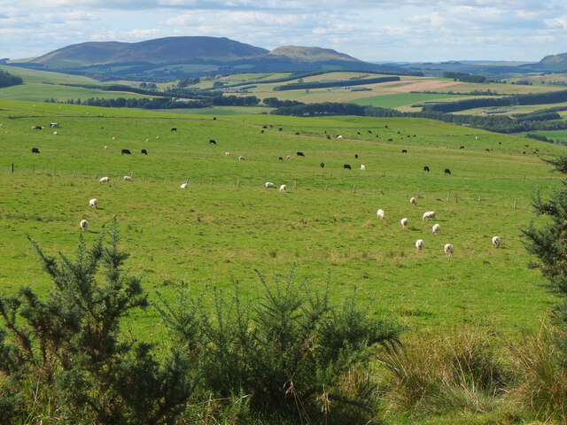
Green Knowe is a prominent hill located in Peeblesshire, Scotland. Situated amidst the picturesque Scottish Borders, it stands as a notable landmark in the region. Rising to an elevation of approximately 445 meters (1,460 feet), it offers breathtaking panoramic views of the surrounding countryside.

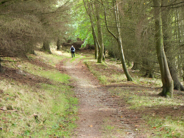
Covered in lush greenery, Green Knowe is a haven for nature enthusiasts and hikers alike. The hill is home to a variety of flora and fauna, including heather, gorse, and various species of birds. Its gentle slopes and well-maintained trails make it an accessible destination for visitors of all ages and fitness levels.

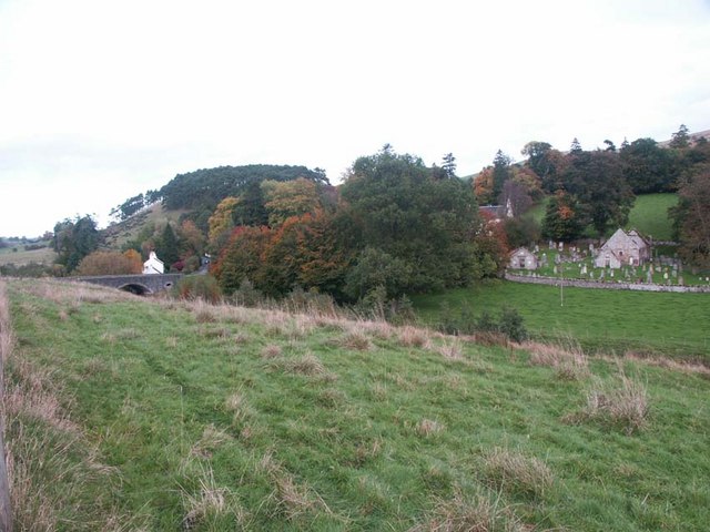
At the summit of Green Knowe, visitors are rewarded with unparalleled vistas of the rolling hills and valleys that typify the Scottish countryside. On clear days, one can even catch glimpses of the majestic Tweed Valley and the distant Scottish Borders. The hill's strategic location also provides opportunities for stargazing, with unobstructed views of the night sky.

Green Knowe holds historical significance as well. It is believed to have been used as a lookout point during ancient times, with remnants of fortifications still visible on its slopes. These archaeological remains serve as a reminder of the area's rich and storied past.

For those seeking a tranquil escape from the bustling city, Green Knowe offers a serene and peaceful retreat. Its natural beauty and tranquil atmosphere make it a must-visit destination for nature lovers and outdoor enthusiasts in Peeblesshire.

If you have any feedback on the listing, please let us know in the comments section below.

Green Knowe Images

Images are sourced within 2km of 55.707369/-3.2925163 or Grid Reference NT1846. Thanks to Geograph Open Source API. All images are credited.

Old drove road near Romanno Hope This track forms part of the Cross Borders Drove Road, a long-distance walking route between Harperrig, south-west of Edinburgh, and Hawick.
Old drove road near Romanno Hope
This track forms part of the Cross Borders Drove Road, a long-distance walking route between Harperrig, south-west of Edinburgh, and Hawick.
Ford on the Fingland Burn near Romanno Hope This track forms part of the Cross Borders Drove Road, a long-distance walking route between Harperrig, south-west of Edinburgh, and Hawick.
Ford on the Fingland Burn near Romanno Hope
This track forms part of the Cross Borders Drove Road, a long-distance walking route between Harperrig, south-west of Edinburgh, and Hawick.
Track on Green Knowe A view down the valley of the Flemington Burn, with the low winter sun highlighting old sheepfolds on the hillsides.
Track on Green Knowe
A view down the valley of the Flemington Burn, with the low winter sun highlighting old sheepfolds on the hillsides.
Mist rolling over forested hillsides above the Flemington Burn It was a day of stark contrasts between bright winter sunshine and banks of mist.
Mist rolling over forested hillsides above the Flemington Burn
It was a day of stark contrasts between bright winter sunshine and banks of mist.
Sunlight and mist on Hag Law A mixture of low winter sunlight and banks of mist made for some atmospheric conditions.
Sunlight and mist on Hag Law
A mixture of low winter sunlight and banks of mist made for some atmospheric conditions.
Hillwalker in the mist on Wether Law Quite a contrast with the bright winter sunshine down in the valley.
Hillwalker in the mist on Wether Law
Quite a contrast with the bright winter sunshine down in the valley.
Path from Romannobridge The Cross Borders Drove Road follows this path to cross the col between Drum Maw and Hag Law.
Path from Romannobridge
The Cross Borders Drove Road follows this path to cross the col between Drum Maw and Hag Law.
Sheep and cattle, Drum Maw Pasture on the lower slopes of Drum Maw with Black Mount (516m) on the skyline.
Sheep and cattle, Drum Maw
Pasture on the lower slopes of Drum Maw with Black Mount (516m) on the skyline.
Path to Romanno Hope A good path on grass leads down to the Fingland Burn. Compare with <a href="https://www.geograph.org.uk/photo/6012175">NT1847 : Descent to Romanno Hope</a> taken in December 2018.
Path to Romanno Hope
A good path on grass leads down to the Fingland Burn. Compare with NT1847 : Descent to Romanno Hope taken in December 2018.
Bridge timber by Fingland Burn Before too long it looks as though a footbridge will be built here in Romanno Hope.
Bridge timber by Fingland Burn
Before too long it looks as though a footbridge will be built here in Romanno Hope.
Valley of the Fingland Burn The burn rises on the western slopes of Wether Law in the Cloich Hills and joins the Flemington Burn a few hundred metres downstream.
Valley of the Fingland Burn
The burn rises on the western slopes of Wether Law in the Cloich Hills and joins the Flemington Burn a few hundred metres downstream.
Confluence of the Fingland and Flemington Burns The Flemington Burn rises on the east side of Wether Law in the Cloich Hills, here meets the Fingland Burn and flows southwest to the Lyne Water.
Confluence of the Fingland and Flemington Burns
The Flemington Burn rises on the east side of Wether Law in the Cloich Hills, here meets the Fingland Burn and flows southwest to the Lyne Water.
Gate into Cloich Forest On the path from Romannobridge, also on the Cross Borders Drove Road.
Gate into Cloich Forest
On the path from Romannobridge, also on the Cross Borders Drove Road.
Path in Cloich Forest The path from the Flemington Burn to the forest road near Courhope, also part of the Cross Borders Drove Road.
Path in Cloich Forest
The path from the Flemington Burn to the forest road near Courhope, also part of the Cross Borders Drove Road.
Forest boundary, Crailzie Hill The western edge of Harehope Forest at the top of Wide Hope.
Forest boundary, Crailzie Hill
The western edge of Harehope Forest at the top of Wide Hope.
The col above Wide Hope Open hillside contrasts with the plantations of Harehope Forest on this col W of Crailzie Hill.
The col above Wide Hope
Open hillside contrasts with the plantations of Harehope Forest on this col W of Crailzie Hill.
Wether Law
Wether Law
Crailzie Hill Summit Forest Ride After Wether Law, with Colin Crawford, Rick Salter, Alan Dawson, Bernie Hughes and Jenny Hatfield. Up ATV and sheep tracks to col by White Hope Shank. To top area by wide forest ride, greasy mush of moss in places slippery! Summit indistinct, minor 'survey' with team and GPS revealed a point accessible inside trees, small wall cairn and arrow now indicates location. Hot and steamy with plenty of mushrooms.
Name: Crailzie Hill
Hill number: 1818
Height: 476m / 1562ft
Area: 28A: Firth of Forth to the River Tweed
Class: Hu,sMa
Grid ref: NT 19439 45257
Summit feature: no feature
Drop: 141m
Col: 335m  NT213476
Crailzie Hill Summit Forest Ride
After Wether Law, with Colin Crawford, Rick Salter, Alan Dawson, Bernie Hughes and Jenny Hatfield. Up ATV and sheep tracks to col by White Hope Shank. To top area by wide forest ride, greasy mush of moss in places slippery! Summit indistinct, minor 'survey' with team and GPS revealed a point accessible inside trees, small wall cairn and arrow now indicates location. Hot and steamy with plenty of mushrooms. Name: Crailzie Hill Hill number: 1818 Height: 476m / 1562ft Area: 28A: Firth of Forth to the River Tweed Class: Hu,sMa Grid ref: NT 19439 45257 Summit feature: no feature Drop: 141m Col: 335m NT213476
Show me another place!

Green Knowe is located at Grid Ref: NT1846 (Lat: 55.707369, Lng: -3.2925163)

Unitary Authority: The Scottish Borders

Police Authority: The Lothians and Scottish Borders

What 3 Words

///reclusive.query.sharpen. Near West Linton, Scottish Borders

Nearby Locations

Green Knowe

Related Wikis

Newlands, Scottish Borders

Newlands is a parish in the Tweeddale committee area of the Scottish Borders council area, in southeastern Scotland. == Geography == Newlands is on the...

Romannobridge

Romanno Bridge is a village on the Lyne Water, on the A701, in the Scottish Borders area of Scotland. Settlements nearby include West Linton, Halmyre,...

Bordlands

Bordlands is a village in the Parish of Newlands in the Scottish Borders area of Scotland. The former name of Bordlands was Boreland. == See also == List...

Drochil Castle

Drochil Castle is a ruined castle in the Scottish Borders. It is located above the Lyne Water, 10 kilometres (6.2 mi) north-west of Peebles, and 8 kilometres...

Nearby Amenities

Located within 500m of 55.707369,-3.2925163
Green Knowe
Ele: 401
Natural: peak
Lat/Long: 55.7086992/-3.2928069
Ford: yes
Lat/Long: 55.7080772/-3.2993305
The data included in this document is from www.openstreetmap.org. The data is made available under ODbL.

Have you been to Green Knowe?

Leave your review of Green Knowe below (or comments, questions and feedback).