Allt Dderw

Hill, Mountain in Radnorshire

Wales

Allt Dderw

Road junction between Bryngwyn and Lower Glasnant
Road junction between Bryngwyn and Lower Glasnant Credit: Oliver Dixon

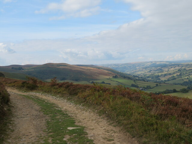
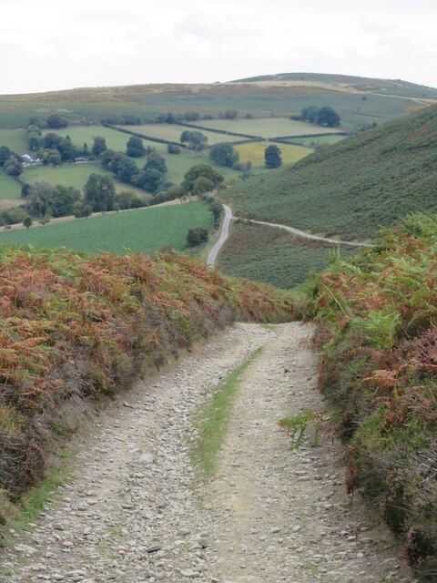
Allt Dderw is a prominent hill located in the county of Radnorshire, Wales. Situated in the heart of the Welsh countryside, it is part of the stunning Cambrian Mountain range. Standing at an elevation of approximately 500 meters (1,640 feet), Allt Dderw offers breathtaking panoramic views of the surrounding landscape.

The hill is characterized by its rugged terrain, with steep slopes covered in heather, grasses, and scattered rocky outcrops. These features make it a popular destination for hikers and nature enthusiasts seeking a challenging yet rewarding climb. The ascent to the summit is challenging but not overly difficult, making it accessible to both experienced and novice walkers.

As visitors make their way up Allt Dderw, they are rewarded with stunning views of the rolling hills, valleys, and nearby lakes. On a clear day, it is even possible to spot the distant peaks of the Black Mountains and the Brecon Beacons to the south.

The hill is also home to a variety of wildlife, including birds of prey such as red kites and buzzards, as well as sheep and wild ponies that roam freely. It is not uncommon to come across grazing livestock while exploring the area.

Allt Dderw offers a peaceful and tranquil setting, providing a perfect escape from the bustle of urban life. Whether it is for a challenging hike, a picnic at the summit, or simply to enjoy the beauty of the Welsh countryside, Allt Dderw is a must-visit destination for nature lovers and outdoor enthusiasts.

If you have any feedback on the listing, please let us know in the comments section below.

Allt Dderw Images

Images are sourced within 2km of 52.144371/-3.2177204 or Grid Reference SO1650. Thanks to Geograph Open Source API. All images are credited.
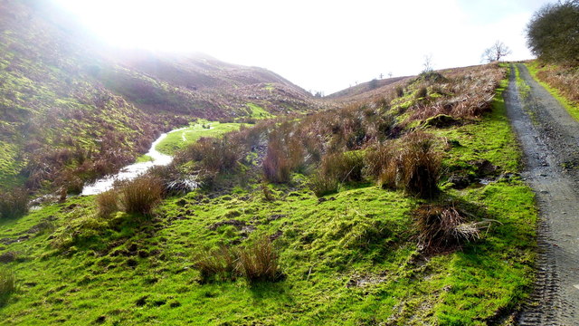
Road junction between Bryngwyn and Lower Glasnant
Track on the NW side of Red Hill A good track which contours around the west side of the hill.
Track on the NW side of Red Hill
A good track which contours around the west side of the hill.
No sign of Doctor's Pool After a very dry summer, several marked pools in the area had either completely dried or just become a mud patch. Doctor's Pool should be down there somewhere, but there's no evidence of water.
No sign of Doctor's Pool
After a very dry summer, several marked pools in the area had either completely dried or just become a mud patch. Doctor's Pool should be down there somewhere, but there's no evidence of water.
Moorland track The track winds down the hillside to where a small pool, Pwll Brwynog, is marked on the map, but on this occasion all that could be seen was a patch of mud.
Moorland track
The track winds down the hillside to where a small pool, Pwll Brwynog, is marked on the map, but on this occasion all that could be seen was a patch of mud.
Mawn Pool [west] The OS map shows several 'Mawn Pools' on the moors in this area. 'Mawn' translates as 'Peat', and one might guess that they are artificial. This is one of the largest pools in the area and is neatly bisected by a grid line. Two rather ramshackle hides are at either side of the pool, no doubt for the use of duck shooters. However, no ducks were to be seen.
Mawn Pool [west]
The OS map shows several 'Mawn Pools' on the moors in this area. 'Mawn' translates as 'Peat', and one might guess that they are artificial. This is one of the largest pools in the area and is neatly bisected by a grid line. Two rather ramshackle hides are at either side of the pool, no doubt for the use of duck shooters. However, no ducks were to be seen.
Take a seat and enjoy the view Someone has kindly left two folding chairs at the side of Mawn Pool, although at around 500m above sea level, there can't be that many days when one might want to relax here.
Take a seat and enjoy the view
Someone has kindly left two folding chairs at the side of Mawn Pool, although at around 500m above sea level, there can't be that many days when one might want to relax here.
Mawn Pool [east] The eastern end of the peat pool [Mawn in Welsh] on the moor at around the 500m contour.
Mawn Pool [east]
The eastern end of the peat pool [Mawn in Welsh] on the moor at around the 500m contour.
Moorland track towards Mawn Pool The moors in this area are criss-crossed by a series of easy-to-follow tracks, although they don't always correspond with those marked on the OS map. The line of nearby grouse butts shown on the map appear to be no more, whilst further down the moorside is a pile of timber that looks like wrecked butts.
Moorland track towards Mawn Pool
The moors in this area are criss-crossed by a series of easy-to-follow tracks, although they don't always correspond with those marked on the OS map. The line of nearby grouse butts shown on the map appear to be no more, whilst further down the moorside is a pile of timber that looks like wrecked butts.
Track across moorland Easy graded track running across the northern slopes of Allt Dderw. This may be an old roadway as it links tarmacked roads no more than 3.5kms apart.
Track across moorland
Easy graded track running across the northern slopes of Allt Dderw. This may be an old roadway as it links tarmacked roads no more than 3.5kms apart.
Descent towards Glasnant The track along the north side of Allt Dderw descends towards a tarmacked road near Glasnant.
Descent towards Glasnant
The track along the north side of Allt Dderw descends towards a tarmacked road near Glasnant.
Lane by Bryngwyn Hill, 1 The lane runs the boundary of moorland with farmland unseen to the right.
Lane by Bryngwyn Hill, 1
The lane runs the boundary of moorland with farmland unseen to the right.
Lane by Bryngwyn Hill, 2 The lane runs the boundary of moorland with improved farmland seen to the left.
Lane by Bryngwyn Hill, 2
The lane runs the boundary of moorland with improved farmland seen to the left.
Fork in the lanes Left is access to farms to the north of Bryngwyn Hill. Right towards Glascwm.
Fork in the lanes
Left is access to farms to the north of Bryngwyn Hill. Right towards Glascwm.
Track and stream Looking into the sun in this isolated spot to the north of Bryngwyn Hill rising to the left. The track to the right ascends Allt Dderw.
Track and stream
Looking into the sun in this isolated spot to the north of Bryngwyn Hill rising to the left. The track to the right ascends Allt Dderw.
That's a switchback The public road descends the north side of Bryngwyn towards Upper Glasnant.
Not quite sure what the earthmoving is for.
That's a switchback
The public road descends the north side of Bryngwyn towards Upper Glasnant. Not quite sure what the earthmoving is for.
Hill farming in Radnorshire Sheep pasture to the west of Upper Glasnant.
Hill farming in Radnorshire
Sheep pasture to the west of Upper Glasnant.
Through the gap to Colva Radnor Forest scenery with a view through a gap towards Colva Hill.
Through the gap to Colva
Radnor Forest scenery with a view through a gap towards Colva Hill.
Sharp bend, Glasnant The road to Upper Glasnant takes a sharp bend. The digger was there a few years earlier <a href="https://www.geograph.org.uk/photo/4821553">SO1750 : That's a switchback</a>
Sharp bend, Glasnant
The road to Upper Glasnant takes a sharp bend. The digger was there a few years earlier SO1750 : That's a switchback
Show me another place!

Allt Dderw is located at Grid Ref: SO1650 (Lat: 52.144371, Lng: -3.2177204)

Unitary Authority: Powys

Police Authority: Dyfed Powys

What 3 Words

///feeds.hypocrite.lipstick. Near Clifford, Herefordshire

Nearby Locations

Allt Dderw

Related Wikis

Rhos Goch National Nature Reserve

Rhos Goch National Nature Reserve, located near Painscastle on the England/Wales border, is one of the largest raised bogs in mid and south Wales. ‘Goch...

Painscastle Rural District

Painscastle was, from 1894 to 1974, a rural district in the administrative county of Radnorshire, Wales. The district was formed by the Local Government...

Newchurch, Powys

Newchurch is a small rural village in Powys, Wales, centred around St Mary's Church. The village is within the community of Gladestry, about 5 miles (8...

Painscastle

Painscastle (Welsh: Castell-paen) is a village and community in Powys (formerly Radnorshire), Wales which takes its name from the castle at its heart....

Nearby Amenities

Located within 500m of 52.144371,-3.2177204
Ford: yes
Lat/Long: 52.1410817/-3.2204308
Ford: yes
Source: GPS Survey
Lat/Long: 52.1463125/-3.2230327
Allt Dderw
Ele: 457
Natural: peak
Lat/Long: 52.144504/-3.2176048
Source: OS-OpenData_StreetView
Lat/Long: 52.1472824/-3.2222289
The data included in this document is from www.openstreetmap.org. The data is made available under ODbL.

Have you been to Allt Dderw?

Leave your review of Allt Dderw below (or comments, questions and feedback).