Cnoc Lochy
Hill, Mountain in Banffshire
Scotland
Cnoc Lochy
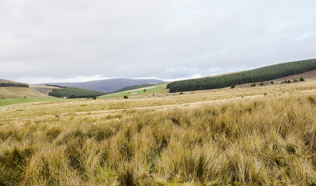
![Across a marshy plain towards Tomintoul Tomintoul is reputed to be the highest village in the Highlands [but considerably lower than the highest in the Southern Uplands] and occupies a relatively flat site between the Conglass Water, seen here in the foreground, and the River Avon on the far side of the village. The site is not only high, but exposed, with the snow streaked Cairngorms in the distance.](https://s0.geograph.org.uk/geophotos/07/17/55/7175584_42bdd42a.jpg)
Cnoc Lochy is a prominent hill located in Banffshire, a historic county in northeastern Scotland. It is situated near the village of Aberchirder, also known as Foggieloan, and stands at an elevation of approximately 309 meters (1,014 feet) above sea level. The hill is a notable landmark in the region, offering stunning panoramic views of the surrounding countryside.
Cnoc Lochy is characterized by its undulating terrain and gentle slopes, covered with heather and grasses typical of the Scottish Highlands. The hill is accessible via a well-maintained path, making it a popular destination for hikers and nature enthusiasts. As visitors ascend Cnoc Lochy, they can enjoy the picturesque landscapes and observe various species of wildlife, including birds, deer, and small mammals.
At the summit of Cnoc Lochy, one can find a cairn, a man-made pile of stones, which serves as a marker and adds to the hill's aesthetic appeal. From this vantage point, one can admire the breathtaking vistas of the rolling hills, lush valleys, and nearby Loch of Auchintoul.
Cnoc Lochy and its surroundings hold historical significance, as the area is dotted with remnants of ancient settlements and structures. These archaeological sites provide insights into the region's rich cultural heritage.
Overall, Cnoc Lochy is a charming and accessible hill that offers visitors an opportunity to immerse themselves in the natural beauty and history of Banffshire, making it a worthwhile destination for outdoor enthusiasts and those seeking tranquility amidst stunning Scottish landscapes.
If you have any feedback on the listing, please let us know in the comments section below.
Cnoc Lochy Images
Images are sourced within 2km of 57.271989/-3.3887788 or Grid Reference NJ1621. Thanks to Geograph Open Source API. All images are credited.


Cnoc Lochy is located at Grid Ref: NJ1621 (Lat: 57.271989, Lng: -3.3887788)
Unitary Authority: Moray
Police Authority: North East
What 3 Words
///remaining.island.city. Near Grantown-on-Spey, Highland
Nearby Locations
Related Wikis
Tomintoul
Tomintoul ( ; from Scottish Gaelic: Tom an t-Sabhail, meaning "Hillock of the Barn") is a village in the Moray council area of Scotland in the historic...

Glenlivet Estate
The Glenlivet Estate is located in Glenlivet, Scotland in the Cairngorms National Park. It measures 58,000 acres (230 km2) and is part of The Crown Estate...

Kirkmichael, Moray
Kirkmichael is a parish and hamlet in Moray, Scotland. Kirkmichael was historically part of Banffshire.The hamlet lies approximately 8 miles south of Ballindalloch...

Tomintoul distillery
Tomintoul distillery is a distillery in Kirkmichael, between Ballindalloch and Tomintoul in the Speyside region of Scotland, producing malt whisky for...
Nearby Amenities
Located within 500m of 57.271989,-3.3887788Have you been to Cnoc Lochy?
Leave your review of Cnoc Lochy below (or comments, questions and feedback).