Drumelzier Law

Hill, Mountain in Peeblesshire

Scotland

Drumelzier Law

Track ascending Den Knowes, Pykestone Hill
Track ascending Den Knowes, Pykestone Hill Credit: Colin Park

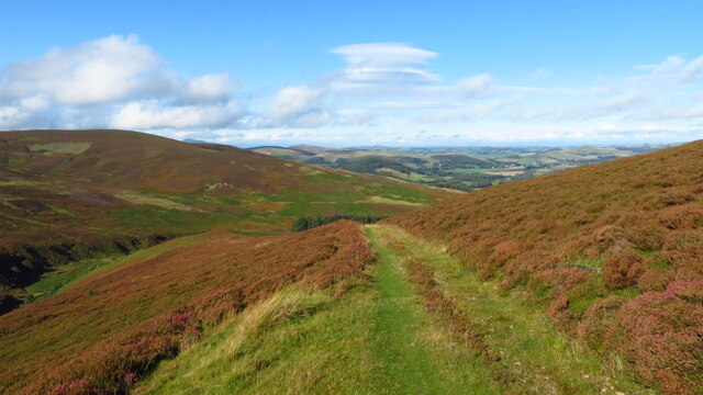
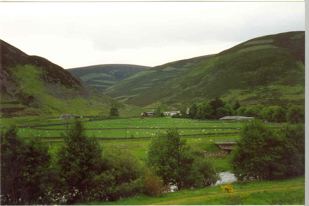
Drumelzier Law is a prominent hill located in the Peeblesshire region of Scotland. Rising to an elevation of approximately 535 meters (1,755 feet), it offers breathtaking panoramic views of the surrounding countryside. The hill is situated near the picturesque village of Drumelzier, which lies in the valley of the River Tweed.

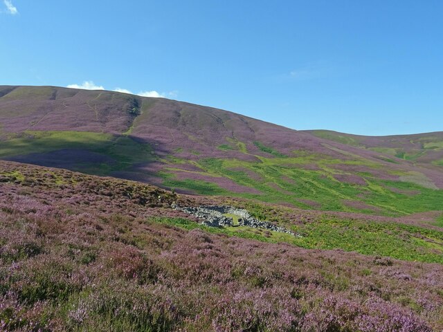
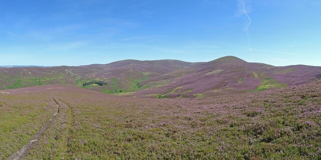
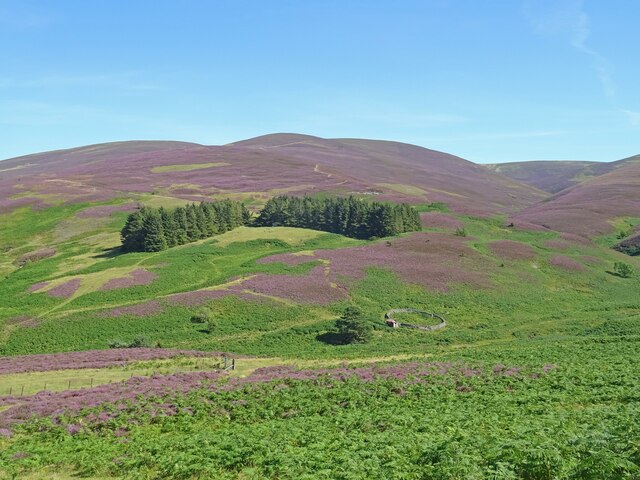
Drumelzier Law is characterized by its distinctive conical shape, making it a notable landmark in the area. Its summit is crowned with an ancient hillfort, believed to date back to the Iron Age. The hillfort is enclosed by a series of earthworks and remains of ramparts, providing insight into the historical significance of the site.

The ascent to the top of Drumelzier Law is a popular activity among outdoor enthusiasts, offering a moderately challenging hike. The hill boasts a variety of walking trails, accommodating both experienced hikers and casual walkers. Along the way, visitors can appreciate the diverse flora and fauna, including heather, mosses, and an array of bird species.

The hill's location in the heart of the Scottish Borders makes it a convenient destination for nature lovers and history enthusiasts alike. The surrounding area is rich in cultural heritage, with nearby attractions such as the Dawyck Botanic Garden and the John Buchan Way, a long-distance trail named after the renowned Scottish author.

In conclusion, Drumelzier Law is a stunning hill in Peeblesshire, Scotland, boasting a unique shape, an ancient hillfort, and a range of walking trails. Its captivating views and historical significance make it a must-visit destination for those exploring the Scottish Borders.

If you have any feedback on the listing, please let us know in the comments section below.

Drumelzier Law Images

Images are sourced within 2km of 55.567184/-3.3502463 or Grid Reference NT1431. Thanks to Geograph Open Source API. All images are credited.

Track ascending Den Knowes, Pykestone Hill
Approaching Shepherds Cairn on Glenstivon Dod A faint path runs along the broad ridge.
Approaching Shepherds Cairn on Glenstivon Dod
A faint path runs along the broad ridge.
Descending from Glenstivon Dod towards Drumelzier Law A decent path runs along this ridge giving some fine walking.
Descending from Glenstivon Dod towards Drumelzier Law
A decent path runs along this ridge giving some fine walking.
Lower Slopes of Drumelzier Law Lovely early autumnal/late summer colours in the hills south of Drumelzier.
The differing shades of purple showing that both Common Heather and Bell Heather are in abundance on the hills here.
Lower Slopes of Drumelzier Law
Lovely early autumnal/late summer colours in the hills south of Drumelzier. The differing shades of purple showing that both Common Heather and Bell Heather are in abundance on the hills here.
Den Knowes Head High up on the northern slopes of Pykestone Hill with fine views of from left Drumelzier Law, Culter Fell, Chapelgill Hill and Tinto. A grand day out in the Borders with a nice breeze to cool off.
Den Knowes Head
High up on the northern slopes of Pykestone Hill with fine views of from left Drumelzier Law, Culter Fell, Chapelgill Hill and Tinto. A grand day out in the Borders with a nice breeze to cool off.
Drumelzier Law On lovely ground between Glenstivon Dod looking towards Drumelzier Law - fine Borders scenery and walking country. Very different colours to this image here from abut 6 weeks later in the year in 2021.
<a title="https://www.geograph.org.uk/photo/7032846" href="https://www.geograph.org.uk/photo/7032846">Link</a>
Drumelzier Law
On lovely ground between Glenstivon Dod looking towards Drumelzier Law - fine Borders scenery and walking country. Very different colours to this image here from abut 6 weeks later in the year in 2021. Link
All around the bloomin' heather Heather in full bloom on the hills south of Drumelzier. A grand day to be out in the bloomin' heather though not sure there is wild mountain thyme about.
Very different colours to this scene from October 2020 from about the same spot.
<a title="https://www.geograph.org.uk/photo/6627939" href="https://www.geograph.org.uk/photo/6627939">Link</a>
All around the bloomin' heather
Heather in full bloom on the hills south of Drumelzier. A grand day to be out in the bloomin' heather though not sure there is wild mountain thyme about. Very different colours to this scene from October 2020 from about the same spot. Link
Heather in Full Bloom Sheepfold above the Drumelzier Burn and the lower slopes of Pykestone Hill seen from Finglen Rig. Heather in full bloom and very different to the relatively drab colours seen here in October 2020:-
<a title="https://www.geograph.org.uk/photo/6627953" href="https://www.geograph.org.uk/photo/6627953">Link</a>
Heather in Full Bloom
Sheepfold above the Drumelzier Burn and the lower slopes of Pykestone Hill seen from Finglen Rig. Heather in full bloom and very different to the relatively drab colours seen here in October 2020:- Link
Pykestone Hill and Drumelzier Law A circular hill walking loop is possible starting and finishing in the hamlet of Drumelzier.
Pykestone Hill and Drumelzier Law
A circular hill walking loop is possible starting and finishing in the hamlet of Drumelzier.
Middle Hill Bump in the Tweedsmuir Hills.
Middle Hill
Bump in the Tweedsmuir Hills.
Hopekist Plantation A 1980s planted conifer wood on the north side of Taberon Law.
Hopekist Plantation
A 1980s planted conifer wood on the north side of Taberon Law.
Ride, Hopekist An unplanted strip with a path running along it. Often these rides in conifer plantations can be heavy going, but not here. There is a deer seat at a ride junction in the distance.
Ride, Hopekist
An unplanted strip with a path running along it. Often these rides in conifer plantations can be heavy going, but not here. There is a deer seat at a ride junction in the distance.
Ride, Hopekist Plantation An unplanted strip between those upland favourites: Lodgepole pine and Sitka spruce.
Ride, Hopekist Plantation
An unplanted strip between those upland favourites: Lodgepole pine and Sitka spruce.
Deer seat, Hopekist Plantation Situated at a ride junction.
Deer seat, Hopekist Plantation
Situated at a ride junction.
Hopecarton Burn Burn in an eroded gulley on Easton Hope, below Middle Hill.
Hopecarton Burn
Burn in an eroded gulley on Easton Hope, below Middle Hill.
Drumelzier Burn Steep V shaped valley running down to the Tweed. The track is used by shepherds to get around the vast acreage of sheepwalk on the surrounding hills.
Drumelzier Burn
Steep V shaped valley running down to the Tweed. The track is used by shepherds to get around the vast acreage of sheepwalk on the surrounding hills.
Drumelzier Burn Looking up the Drumelzier glen to Drumelzier Law (668m), a striking spur of the Tweedsmuir hill plateau.
Drumelzier Burn
Looking up the Drumelzier glen to Drumelzier Law (668m), a striking spur of the Tweedsmuir hill plateau.
Drumelzier Law The summit area. Constant exposure to wind keeps the vegetation close to the ground. Walk away from the ridge and deep heather returns.
Drumelzier Law
The summit area. Constant exposure to wind keeps the vegetation close to the ground. Walk away from the ridge and deep heather returns.
Show me another place!

Drumelzier Law is located at Grid Ref: NT1431 (Lat: 55.567184, Lng: -3.3502463)

Unitary Authority: The Scottish Borders

Police Authority: The Lothians and Scottish Borders

What 3 Words

///deck.snowmen.unrated. Near Biggar, South Lanarkshire

Nearby Locations

Drumelzier Law

Related Wikis

Stanhope, Peeblesshire

Stanhope is a small settlement in the Scottish Borders region. It is situated in the parish of Drumelzier in Peeblesshire, in the valley of the River...

Mossfennan

Mossfennan is a small settlement in southern Scotland near Drumelzier in the Scottish Borders, in the valley of the River Tweed. Mossfennan is a wooded...

Drumelzier

Drumelzier (), is a village and civil parish on the B712 in the Tweed Valley in the Scottish Borders. The area of the village is extensive and includes...

Wrae Tower

Wrae Tower is a ruined 16th-century stone tower house, located in the upper Tweed Valley in the Scottish Borders area of Scotland, and similarly south...

Dawyck Chapel

Dawyck Chapel, also known as Dalwick Church, is located (NGR NT 16798 34933) within the Parish of Drumelzier in the Scottish Borders area of Scotland....

Bellspool

Bellspool is a village in the Scottish Borders area of Scotland, near to Drumelzier, Hopcarton and Kingledoors == See also == List of places in the Scottish...

Biggar Water

Biggar Water is a river in Lanarkshire and Peeblesshire, in the Southern Uplands of Scotland. It forms part of the River Tweed system. It rises, as Biggar...

Dawyck Botanic Garden

Dawyck Botanic Garden is a botanic garden and arboretum covering 25 hectares (62 acres) at Stobo on the B712, 8 miles (13 kilometres) south of Peebles...

Nearby Amenities

Located within 500m of 55.567184,-3.3502463
Drumelzier Law
Natural: peak
Wikidata: Q96376655
Wikipedia: en:Drumelzier Law
Lat/Long: 55.567665/-3.3508382
The data included in this document is from www.openstreetmap.org. The data is made available under ODbL.

Have you been to Drumelzier Law?

Leave your review of Drumelzier Law below (or comments, questions and feedback).