Cnap Chaochan Aitinn

Hill, Mountain in Banffshire

Scotland

Cnap Chaochan Aitinn

Coire nan Sac A small corrie draining into the River Avon near Dail nan Sac.
Coire nan Sac Credit: Anne Burgess

Cnap Chaochan Aitinn, also known as Cnap Chaochan Aitinn Hill or Mountain, is located in Banffshire, Scotland. It is situated within the Cairngorms National Park, a region famous for its stunning natural landscapes and diverse wildlife.

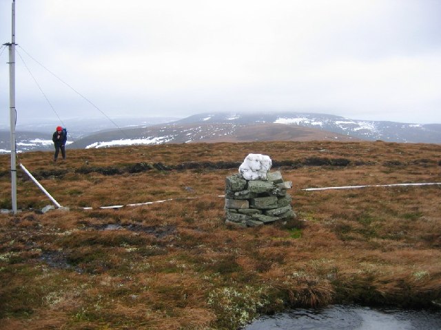
Cnap Chaochan Aitinn stands at an elevation of approximately 800 meters (2,625 feet) above sea level, making it a prominent feature in the area. The hill/mountain is characterized by its gently sloping terrain, covered in a mix of heather, grasses, and scattered rocks. Its summit provides breathtaking panoramic views of the surrounding countryside, including the nearby Cairngorm Mountains.

The hill/mountain is a popular destination for outdoor enthusiasts, offering opportunities for hiking, hillwalking, and mountaineering. There are several established trails and routes that lead to the summit, catering to both experienced hikers and those seeking a more leisurely stroll through the countryside. As visitors ascend the hill, they may spot various species of birds, such as ptarmigans and golden eagles, as well as other wildlife like mountain hares and red deer.

Cnap Chaochan Aitinn is also of historical and archaeological significance, with remnants of ancient settlements and burial mounds scattered throughout the area. These remnants provide insights into the human presence in the region dating back thousands of years.

Overall, Cnap Chaochan Aitinn in Banffshire offers a captivating blend of natural beauty, adventure, and cultural heritage, making it a must-visit destination for nature enthusiasts and history buffs alike.

If you have any feedback on the listing, please let us know in the comments section below.

Cnap Chaochan Aitinn Images

Images are sourced within 2km of 57.172512/-3.4142706 or Grid Reference NJ1409. Thanks to Geograph Open Source API. All images are credited.

Coire nan Sac A small corrie draining into the River Avon near Dail nan Sac.
Coire nan Sac
A small corrie draining into the River Avon near Dail nan Sac.
River Avon Looking upriver, with the steep slope of The Neilead on the left.
River Avon
Looking upriver, with the steep slope of The Neilead on the left.
Allt Nathrach Allt Nathrach joins the River Avon here.
Allt Nathrach
Allt Nathrach joins the River Avon here.
Burn of Loin From Cnap Chaochan Aitinn. The tributary is Caochan Garvoun.
Burn of Loin
From Cnap Chaochan Aitinn. The tributary is Caochan Garvoun.
On a heathery ridge above Glen Loin Ben Avon forms the background.
On a heathery ridge above Glen Loin
Ben Avon forms the background.
Summit of Big Garvoun An old, overgrown cairn marks the spot.
Ben Avon and Beinn a' Bhuird in the distance.
Summit of Big Garvoun
An old, overgrown cairn marks the spot. Ben Avon and Beinn a' Bhuird in the distance.
Summit of Cnap Chaochan Aitin. A 715m high hill in the eastern Monadh Ruadh was a tough proposition on a very windy day. The estate maintains a radio relay up here; it's quite a cluttered summit.
Summit of Cnap Chaochan Aitin.
A 715m high hill in the eastern Monadh Ruadh was a tough proposition on a very windy day. The estate maintains a radio relay up here; it's quite a cluttered summit.
Track, Glen Loin Hill track going down from Cnap Chaochan Aitinn to meet the main Glen Loin track.
Track, Glen Loin
Hill track going down from Cnap Chaochan Aitinn to meet the main Glen Loin track.
Burn of Loin Flowing through Glen Loin below scree slopes of Cnap Eas Chaorach.
Burn of Loin
Flowing through Glen Loin below scree slopes of Cnap Eas Chaorach.
Glen Loin Track passing below Cnap Chaochan Aitinn with the southwestern slopes of Cnap Eas Chaorach ahead.
Glen Loin
Track passing below Cnap Chaochan Aitinn with the southwestern slopes of Cnap Eas Chaorach ahead.
Track in Glen Loin A track which runs the length of this remote and peaceful glen.
Track in Glen Loin
A track which runs the length of this remote and peaceful glen.
Big Garvoun from Glen Loin North eastern slopes seen across Burn of Loin
Big Garvoun from Glen Loin
North eastern slopes seen across Burn of Loin
Summit cairn of Cnap Chaochan Aitinn Cnap Chaochan Aitinn is a remote summit of the northern Cairngorms; Cairn Gorm itself is distant, above the cairn and Bynack Mor is left of the aerial-like structure.
Summit cairn of Cnap Chaochan Aitinn
Cnap Chaochan Aitinn is a remote summit of the northern Cairngorms; Cairn Gorm itself is distant, above the cairn and Bynack Mor is left of the aerial-like structure.
Moorland above Coire Nathrach with Glen Avon beyond
Turning circle at  the end of the landrover  track
Turning circle at the end of the landrover track
River Avon Long range views are curtailed by the early morning mist. They say the water of the A'an runs as clear as gin. It certainly does....and it tastes good too!
River Avon
Long range views are curtailed by the early morning mist. They say the water of the A'an runs as clear as gin. It certainly does....and it tastes good too!
Disused Cottage at Dalestie It's well into the morning before the sun reaches this side of Glen Avon.
Disused Cottage at Dalestie
It's well into the morning before the sun reaches this side of Glen Avon.
Glen Avon at Dalestie Early morning mist hangs around until the sun eventually rises high enough to shine into the steep sided glen.
Glen Avon at Dalestie
Early morning mist hangs around until the sun eventually rises high enough to shine into the steep sided glen.
Show me another place!

Cnap Chaochan Aitinn is located at Grid Ref: NJ1409 (Lat: 57.172512, Lng: -3.4142706)

Unitary Authority: Moray

Police Authority: North East

What 3 Words

///list.travels.dozens. Near Grantown-on-Spey, Highland

Related Wikis

Delnadamph Lodge

Delnadamph Lodge was located on the Balmoral Estate about 8 miles (13 km) north of the castle. The lodge and its estate lands were bought by Queen Elizabeth...

Ben Avon

Ben Avon (Scottish Gaelic: Beinn Athfhinn, 'mountain of the Avon') is a mountain in the Cairngorms of Scotland. It is a sprawling mountain with a broad...

Tomintoul

Tomintoul ( ; from Scottish Gaelic: Tom an t-Sabhail, meaning "Hillock of the Barn") is a village in the Moray council area of Scotland in the historic...

Nearby Amenities

Located within 500m of 57.172512,-3.4142706
Cnap Chaochan Aitinn
Corbett: no
Ele: 715
Graham: yes
Marilyn: yes
Munro: no
Natural: peak
Prominence: 158
Lat/Long: 57.17246/-3.4146808
The data included in this document is from www.openstreetmap.org. The data is made available under ODbL.

Have you been to Cnap Chaochan Aitinn?

Leave your review of Cnap Chaochan Aitinn below (or comments, questions and feedback).