Black Combe

Hill, Mountain in Cumberland Copeland

England

Black Combe

Heather in bloom by the Black Combe path As well as being pleasing to the eye, a wonderful fragrance emanated from this expansive area of heather north of Townend Knotts.

This photograph was taken during the Coronavirus (COVID-19) pandemic of 2020/21.
Heather in bloom by the Black Combe path Credit: James T M Towill

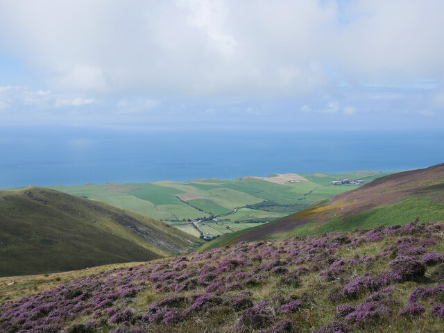
Black Combe is a prominent hill located in the county of Cumberland, in the northwest region of England. Standing at an elevation of 600 meters (1,969 feet), it is often referred to as both a hill and a mountain due to its impressive height and commanding presence.

Situated within the Lake District National Park, Black Combe offers breathtaking views of the surrounding landscape. Its summit provides an expansive panorama that includes the Irish Sea to the west, the Isle of Man, and the nearby fells and mountains of the Lake District. On a clear day, it is even possible to catch a glimpse of the mountains of Scotland.

The hill is composed mainly of volcanic rock, which has eroded over time to form a distinctive shape and steep slopes. The lower slopes are covered in grassland and heather, while the higher regions are mostly bare, exposing the rocky terrain.

Black Combe is a popular destination for hikers and walkers, offering a variety of routes to suit all levels of experience. The ascent to the summit can be challenging, particularly in adverse weather conditions, but the rewarding views make it a worthwhile endeavor.

The hill is also home to a diverse range of flora and fauna, including various species of birds, butterflies, and wildflowers. Nature enthusiasts can spot red grouse, skylarks, and even the occasional golden eagle soaring above.

Overall, Black Combe is a picturesque and awe-inspiring hill/mountain that attracts visitors from near and far, offering an unforgettable experience for those who venture to its summit.

If you have any feedback on the listing, please let us know in the comments section below.

Black Combe Images

Images are sourced within 2km of 54.25773/-3.3285747 or Grid Reference SD1385. Thanks to Geograph Open Source API. All images are credited.

Heather in bloom by the Black Combe path As well as being pleasing to the eye, a wonderful fragrance emanated from this expansive area of heather north of Townend Knotts.

This photograph was taken during the Coronavirus (COVID-19) pandemic of 2020/21.
Heather in bloom by the Black Combe path
As well as being pleasing to the eye, a wonderful fragrance emanated from this expansive area of heather north of Townend Knotts. This photograph was taken during the Coronavirus (COVID-19) pandemic of 2020/21.
Hill cloud enveloping Blackcombe Screes The lunchtime view about to be decimated!  Alas, the weather did improve an hour or so later on the return leg of the walk.

This photograph was taken during the Coronavirus (COVID-19) pandemic of 2020/21.
Hill cloud enveloping Blackcombe Screes
The lunchtime view about to be decimated! Alas, the weather did improve an hour or so later on the return leg of the walk. This photograph was taken during the Coronavirus (COVID-19) pandemic of 2020/21.
Triangulation pillar on Black Combe The trig pillar at the top of Black Combe (600m), which is surrounded for the most part by a wind shelter.

This photograph was taken during the Coronavirus (COVID-19) pandemic of 2020/21.
Triangulation pillar on Black Combe
The trig pillar at the top of Black Combe (600m), which is surrounded for the most part by a wind shelter. This photograph was taken during the Coronavirus (COVID-19) pandemic of 2020/21.
Crash site of Beechcraft C-45 44-47194 of the 632nd AMS, 371st Air Service Group, USAF Dating from March 1947, the accident fortunately did not result in the deaths of the two servicemen aboard.  Several pieces of wreckage remain, including a main undercarriage oleo.  For further information, refer to <span class="nowrap"><a title="https://www.peakdistrictaircrashes.co.uk/crash_sites/lake-district/beechcraft-c-45-44-47194-black-combe/" rel="nofollow ugc noopener" href="https://www.peakdistrictaircrashes.co.uk/crash_sites/lake-district/beechcraft-c-45-44-47194-black-combe/">Link</a><img style="margin-left:2px;" alt="External link" title="External link - shift click to open in new window" src="https://s1.geograph.org.uk/img/external.png" width="10" height="10"/></span> , <span class="nowrap"><a title="https://www.baaa-acro.com/crash/crash-beechcraft-c-45-expeditor-near-haverigg" rel="nofollow ugc noopener" href="https://www.baaa-acro.com/crash/crash-beechcraft-c-45-expeditor-near-haverigg">Link</a><img style="margin-left:2px;" alt="External link" title="External link - shift click to open in new window" src="https://s1.geograph.org.uk/img/external.png" width="10" height="10"/></span> and <span class="nowrap"><a title="http://www.yorkshire-aircraft.co.uk/aircraft/lakes/47194.html" rel="nofollow ugc noopener" href="http://www.yorkshire-aircraft.co.uk/aircraft/lakes/47194.html">Link</a><img style="margin-left:2px;" alt="External link" title="External link - shift click to open in new window" src="https://s1.geograph.org.uk/img/external.png" width="10" height="10"/></span> 

Barfield Tarn is the water body to the far left of shot, with the village of Bootle also discernible nearby.

This photograph was taken during the Coronavirus (COVID-19) pandemic of 2020/21.
Crash site of Beechcraft C-45 44-47194 of the 632nd AMS, 371st Air Service Group, USAF
Dating from March 1947, the accident fortunately did not result in the deaths of the two servicemen aboard. Several pieces of wreckage remain, including a main undercarriage oleo. For further information, refer to LinkExternal link , LinkExternal link and LinkExternal link Barfield Tarn is the water body to the far left of shot, with the village of Bootle also discernible nearby. This photograph was taken during the Coronavirus (COVID-19) pandemic of 2020/21.
Descending Black Combe to an impressive view Walney Island and Barrow-in-Furness can be noted on the horizon.  The Outer Barrier at Hodbarrow, by Millom, can be seen in the middle distance, left of shot.  Over to the right, the HMP Haverigg complex is apparent.  The Isle of Man, Blackpool Tower and the Forest of Bowland were the furthest points seen from Black Combe on this day.

This photograph was taken during the Coronavirus (COVID-19) pandemic of 2020/21.
Descending Black Combe to an impressive view
Walney Island and Barrow-in-Furness can be noted on the horizon. The Outer Barrier at Hodbarrow, by Millom, can be seen in the middle distance, left of shot. Over to the right, the HMP Haverigg complex is apparent. The Isle of Man, Blackpool Tower and the Forest of Bowland were the furthest points seen from Black Combe on this day. This photograph was taken during the Coronavirus (COVID-19) pandemic of 2020/21.
Threatening clouds over Black Combe Alas, and rather predictably, they disappeared and blue skies prevailed later!

This photograph was taken during the Coronavirus (COVID-19) pandemic of 2020/21.
Threatening clouds over Black Combe
Alas, and rather predictably, they disappeared and blue skies prevailed later! This photograph was taken during the Coronavirus (COVID-19) pandemic of 2020/21.
Black Combe from lane W of Bankside
Blackcombe Beck from Blackcombe Screes, Black Combe
Walkers heading NE from Black Combe summit
Black Combe from the air Looking over the hill towards the coast.
Black Combe from the air
Looking over the hill towards the coast.
The path to Black Combe A steady climb.
The path to Black Combe
A steady climb.
Black Combe's summit A grand view into Lakeland.
Black Combe's summit
A grand view into Lakeland.
Dusk descends on Black Combe and Morecambe Bay Another special sunset that often enhances a visit to the promenade at Morecambe. Black Combe is the last high ground in the south of the Lake District National Park.
Dusk descends on Black Combe and Morecambe Bay
Another special sunset that often enhances a visit to the promenade at Morecambe. Black Combe is the last high ground in the south of the Lake District National Park.
Path on Little Fell
Path on Little Fell
Morecambe Bay and Black Combe Seen from the Ben My Chree heading for Heysham, showing part of the very extensive wind farms in the bay.
Morecambe Bay and Black Combe
Seen from the Ben My Chree heading for Heysham, showing part of the very extensive wind farms in the bay.
Hill fog on the climb up Black Combe
Cairn on the path up Black Combe
Show me another place!

Black Combe is located at Grid Ref: SD1385 (Lat: 54.25773, Lng: -3.3285747)

Administrative County: Cumbria

District: Copeland

Police Authority: Cumbria

What 3 Words

///reforming.tint.onions. Near Millom, Cumbria

Nearby Locations

Black Combe

Related Wikis

Black Combe

Black Combe is a fell in the south-west corner of the Lake District National Park, England, just 4 miles (6.4 km) from the Irish Sea. It lies near the...

Whicham

Whicham is a hamlet and civil parish in Copeland, Cumbria, England. At the 2011 census the parish had a population of 382. The parish includes the villages...

Whitbeck, Cumbria

Whitbeck is a hamlet and former civil parish, now in the parish of Whicham, in the Copeland district, in the county of Cumbria, England. It was called...

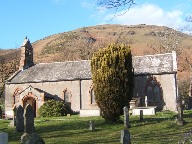
St Mary's Church, Whicham

St Mary's Church is on the A595 road in Whicham, Cumbria, England. It is an active Anglican parish church in the deanery of Calder, the archdeaconry of...

Silecroft railway station

Silecroft is a railway station on the Cumbrian Coast Line, which runs between Carlisle and Barrow-in-Furness. The station, situated 19 miles (31 km) north...

Bootle, Cumbria

Bootle (oo as in boot) is a village and civil parish in the Borough of Copeland in Cumbria, England. The parish had a population of 745 in the 2001 census...

Silecroft

The village of Silecroft in Cumbria, England, is in the parish of Whicham. It is situated between the towns of Millom and Bootle, and also neighbours the...

Annaside

Annaside is a hamlet in Cumbria, England. It is located on the coast by the Irish Sea, about a 1+1⁄2 miles (2+1⁄2 km) south-west of Bootle and 7 miles...

Nearby Amenities

Located within 500m of 54.25773,-3.3285747
Black Combe
Ele: 600
Natural: peak
Source: npe
Wikidata: Q4920562
Wikipedia: en:Black Combe
Lat/Long: 54.2577517/-3.3285761
Eller Peatpot
Place: locality
Lat/Long: 54.2574592/-3.3216584
AVRO ANSON LT741
Historic: yes
Note: Location within approx 50m. It's one the eastern slopes at approx 520m
Lat/Long: 54.2603041/-3.3247312
Ele: 588
Man Made: cairn
Lat/Long: 54.2542054/-3.3285519
Man Made: cairn
Lat/Long: 54.2577394/-3.3285545
Ele: 600
Man Made: survey_point
Ref: 11602
Survey Point Purpose: both
Survey Point Structure: pillar
Lat/Long: 54.2577375/-3.3285657
The data included in this document is from www.openstreetmap.org. The data is made available under ODbL.

Have you been to Black Combe?

Leave your review of Black Combe below (or comments, questions and feedback).