Carn na Ruabraich

Hill, Mountain in Banffshire

Scotland

Carn na Ruabraich

Track, Glen Loin Hill track going down from Cnap Chaochan Aitinn to meet the main Glen Loin track.
Track, Glen Loin Credit: Dorothy Carse

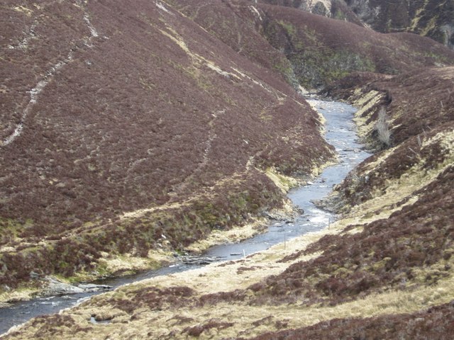
Carn na Ruabraich is a prominent hill located in Banffshire, Scotland. Rising to an elevation of 818 meters (2,684 feet), it forms part of the Grampian Mountains, which stretch across the northeastern region of the country. Situated about 15 kilometers southwest of the town of Ballater, Carn na Ruabraich offers breathtaking views of the surrounding landscape.

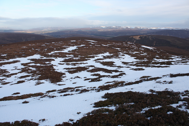
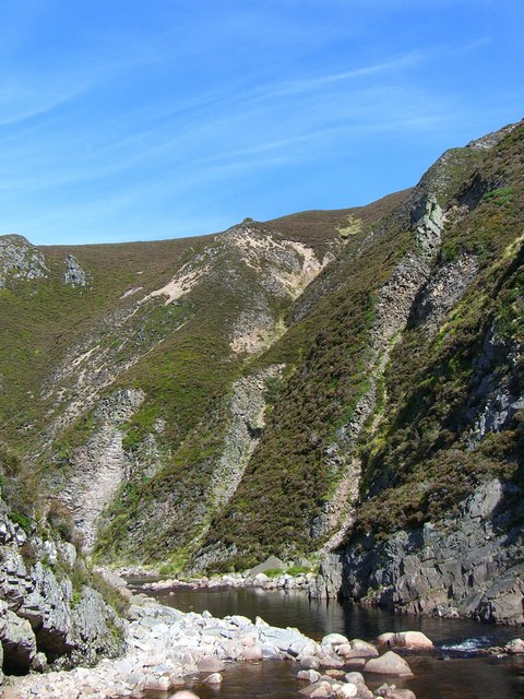
This hill is characterized by its steep slopes and rocky outcrops, making it a popular destination for hikers and mountaineers looking for a challenging ascent. The terrain varies from grassy slopes to scree fields, providing a diverse and exciting experience for outdoor enthusiasts. The summit of Carn na Ruabraich offers panoramic vistas of the surrounding hills, glens, and lochs, rewarding visitors with sweeping views of the Scottish Highlands.

Wildlife is abundant in the area, with sightings of red deer, mountain hares, and various bird species being common. Carn na Ruabraich is also home to a variety of plant life, including heather, moss, and wildflowers, which add a splash of color to the landscape during the warmer months.

Access to Carn na Ruabraich is relatively straightforward, with several well-marked trails leading to the summit. However, it is essential to come prepared with appropriate hiking gear and navigation tools, as the weather conditions in this region can be unpredictable and change rapidly.

Overall, Carn na Ruabraich offers outdoor enthusiasts an opportunity to immerse themselves in the stunning natural beauty of Banffshire, with its challenging terrain and breathtaking views making it a must-visit destination for those seeking adventure in the Scottish Highlands.

If you have any feedback on the listing, please let us know in the comments section below.

Carn na Ruabraich Images

Images are sourced within 2km of 57.179637/-3.4418056 or Grid Reference NJ1210. Thanks to Geograph Open Source API. All images are credited.

Track, Glen Loin Hill track going down from Cnap Chaochan Aitinn to meet the main Glen Loin track.
Track, Glen Loin
Hill track going down from Cnap Chaochan Aitinn to meet the main Glen Loin track.
Glen Loin Track passing below Cnap Chaochan Aitinn with the southwestern slopes of Cnap Eas Chaorach ahead.
Glen Loin
Track passing below Cnap Chaochan Aitinn with the southwestern slopes of Cnap Eas Chaorach ahead.
Summit cairn of Cnap Chaochan Aitinn Cnap Chaochan Aitinn is a remote summit of the northern Cairngorms; Cairn Gorm itself is distant, above the cairn and Bynack Mor is left of the aerial-like structure.
Summit cairn of Cnap Chaochan Aitinn
Cnap Chaochan Aitinn is a remote summit of the northern Cairngorms; Cairn Gorm itself is distant, above the cairn and Bynack Mor is left of the aerial-like structure.
Green bothy below Carn Ruadh-bhreac A lunch bothy on Dorback estate.
Green bothy below Carn Ruadh-bhreac
A lunch bothy on Dorback estate.
Landrover track , Geal Charn Beag Giving access to grouse butts on the NE slopes of the hill.
Landrover track , Geal Charn Beag
Giving access to grouse butts on the NE slopes of the hill.
Track on Geal Charn Beag Landrover track used as access to grouse butts on the NE side of the hill.
Track on Geal Charn Beag
Landrover track used as access to grouse butts on the NE side of the hill.
Snow filled track on Geal Charn Beag Near the end of a landrover track to grouse butts on the NE slopes of the hill.  The Ladder Hills can be seen in the distance.
Snow filled track on Geal Charn Beag
Near the end of a landrover track to grouse butts on the NE slopes of the hill. The Ladder Hills can be seen in the distance.
Slopes of Geal Charn Beag Snow patches lying NE of the summit.  The Ladder Hills can be seen in the distance.
Slopes of Geal Charn Beag
Snow patches lying NE of the summit. The Ladder Hills can be seen in the distance.
Geal Charn Beag summit plateau A flat area of bogs and peat hags.  Looking south towards Ben Avon.
Geal Charn Beag summit plateau
A flat area of bogs and peat hags. Looking south towards Ben Avon.
Water of Caiplich Water of Caiplich looking upstream
Water of Caiplich
Water of Caiplich looking upstream
Water of Caiplich The Water of Caiplich looking downstream from above the southern bank
Water of Caiplich
The Water of Caiplich looking downstream from above the southern bank
Water of Caiplich Water of Caiplich looking upstream above the Castle
Water of Caiplich
Water of Caiplich looking upstream above the Castle
North side of Cnap Chaochan Aitinn. Taken at NJ143106 this is typical of a vast area around here, moorland given over to deer stalking and grouse shooting. Grouse butts are just visible.
North side of Cnap Chaochan Aitinn.
Taken at NJ143106 this is typical of a vast area around here, moorland given over to deer stalking and grouse shooting. Grouse butts are just visible.
Gorge at The Castle
Gorge at The Castle
Gorge at The Castle Slopes of Carn na Ruabraich to right
Gorge at The Castle
Slopes of Carn na Ruabraich to right
Track on Carn an t-Sleibhe Estate track crossing grouse moors above Glen Avon
Track on Carn an t-Sleibhe
Estate track crossing grouse moors above Glen Avon
Track Junction The left track goes to grouse butts on Geal Charn, the right goes to Glen Loin
Track Junction
The left track goes to grouse butts on Geal Charn, the right goes to Glen Loin
Track Junction on Cnap Chaochan Aitinn On the west side of the hill, the main track goes on to zig zag down into Glen Loin while the track to the left goes up towards the summit.
Track Junction on Cnap Chaochan Aitinn
On the west side of the hill, the main track goes on to zig zag down into Glen Loin while the track to the left goes up towards the summit.
Show me another place!

Carn na Ruabraich is located at Grid Ref: NJ1210 (Lat: 57.179637, Lng: -3.4418056)

Unitary Authority: Moray

Police Authority: North East

What 3 Words

///yachting.free.bump. Near Grantown-on-Spey, Highland

Related Wikis

Tomintoul

Tomintoul ( ; from Scottish Gaelic: Tom an t-Sabhail, meaning "Hillock of the Barn") is a village in the Moray council area of Scotland in the historic...

Ben Avon

Ben Avon (Scottish Gaelic: Beinn Athfhinn, 'mountain of the Avon') is a mountain in the Cairngorms of Scotland. It is a sprawling mountain with a broad...

Bynack More

Bynack More (Scottish Gaelic: A' Bheithneag Mhòr or Beinn Bheithneag) is a Scottish Mountain that is situated in the Cairngorms range, 16 kilometres east...

Delnadamph Lodge

Delnadamph Lodge was located on the Balmoral Estate about 8 miles (13 km) north of the castle. The lodge and its estate lands were bought by Queen Elizabeth...

Nearby Amenities

Located within 500m of 57.179637,-3.4418056
Càrn na Ruabraich
Ele: 689
Natural: peak
Lat/Long: 57.179483/-3.4405158
The data included in this document is from www.openstreetmap.org. The data is made available under ODbL.

Have you been to Carn na Ruabraich?

Leave your review of Carn na Ruabraich below (or comments, questions and feedback).