Bank Top

Settlement in Lancashire

England

Bank Top

Bakery Silos Off Waters Meeting Road. The former Astley Bridge railway branch ran across the foreground here (about the camera position) and into the scrub on the right.
Bakery Silos Credit: Kevin Waterhouse

Bank Top is a small village located in the county of Lancashire in Northwest England. Situated just over 3 miles east of Blackburn and approximately 10 miles north of Manchester, Bank Top is a rural community with a population of around 1,500 residents.

The village is known for its picturesque countryside and charming rural setting. Surrounded by rolling hills and green fields, Bank Top offers a tranquil and peaceful atmosphere for residents and visitors alike. The area is predominantly residential, with a mix of traditional stone-built cottages and more modern housing developments.

Bank Top has a strong sense of community, with several local amenities and facilities that cater to the needs of its residents. These include a post office, a convenience store, and a primary school, providing essential services and education for the village population.

The village is well-connected in terms of transportation, with regular bus services running to nearby towns and cities. The M65 motorway is also easily accessible, providing convenient links to the wider region.

Although Bank Top is a relatively small village, it benefits from its close proximity to larger urban centers. Residents can enjoy the convenience of nearby amenities and services, including shopping centers, entertainment venues, and a range of restaurants and cafes.

Overall, Bank Top is an idyllic rural village that offers a peaceful and close-knit community, while still providing easy access to the amenities and opportunities of larger nearby towns and cities.

If you have any feedback on the listing, please let us know in the comments section below.
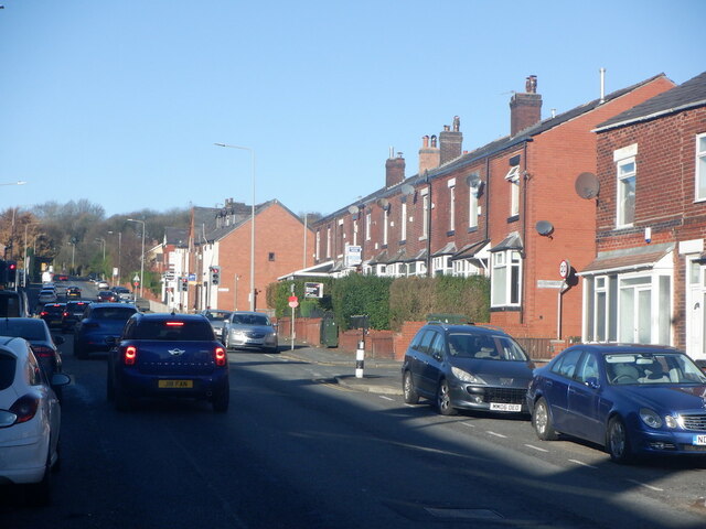
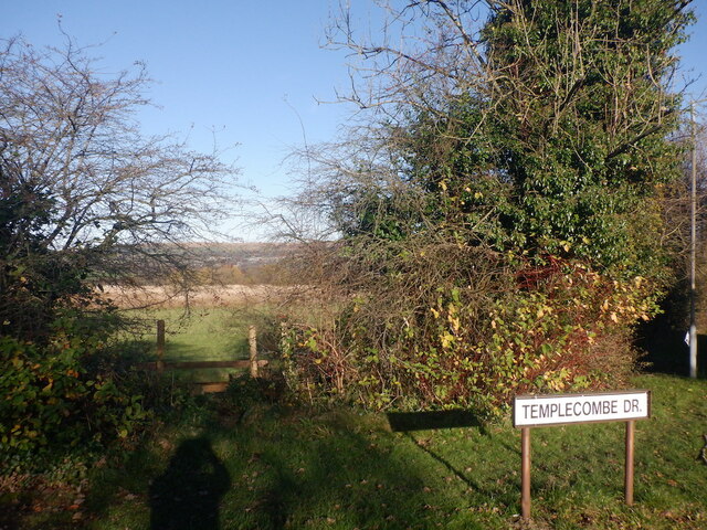
Bank Top Images

Images are sourced within 2km of 53.605164/-2.420861 or Grid Reference SD7212. Thanks to Geograph Open Source API. All images are credited.

Bakery Silos Off Waters Meeting Road. The former Astley Bridge railway branch ran across the foreground here (about the camera position) and into the scrub on the right.
Bakery Silos
Off Waters Meeting Road. The former Astley Bridge railway branch ran across the foreground here (about the camera position) and into the scrub on the right.
Footbridge across River Tonge The path crossing the river links Waters Meeting Road with Union Road
Footbridge across River Tonge
The path crossing the river links Waters Meeting Road with Union Road
Tonge Moor Road A road connecting Bradshaw with Bolton town centre.
Tonge Moor Road
A road connecting Bradshaw with Bolton town centre.
Rest a while A small garden at the junction of Turton Road and Bradshaw Brow.
Rest a while
A small garden at the junction of Turton Road and Bradshaw Brow.
Smithills Open Farm Car Park
Harwood, Longsight Lane
The Tap, Belmont Road
Belmont Road, Bolton Climbing towards the moors.
Belmont Road, Bolton
Climbing towards the moors.
Gap in the hedge off Belmont Road The current edge of built up Bolton, but the field looks as if it has seen very little agricultural activity of late.
Gap in the hedge off Belmont Road
The current edge of built up Bolton, but the field looks as if it has seen very little agricultural activity of late.
Ribbon development, Belmont Road
An unused field off Belmont Road On the edge of Bolton and probably soon to become part of Bolton.
An unused field off Belmont Road
On the edge of Bolton and probably soon to become part of Bolton.
Bungalows on Hough Fold Way Residential area in Harwood, Bolton.
Bungalows on Hough Fold Way
Residential area in Harwood, Bolton.
Oaks Lane, Bradshaw Leading to the now closed Oaks railway station on the Bolton to Blackburn line.
Oaks Lane, Bradshaw
Leading to the now closed Oaks railway station on the Bolton to Blackburn line.
Laburnum Park, Bradshaw Residential development off Oaks Lane.
Laburnum Park, Bradshaw
Residential development off Oaks Lane.
Retreat Bar and Grill Formerly a Wesleyan School on Darwen Road in Bromley Cross.
Retreat Bar and Grill
Formerly a Wesleyan School on Darwen Road in Bromley Cross.
Houses on Andrew Lane In Sharples, Bolton.
Houses on Andrew Lane
In Sharples, Bolton.
Lakenheath Drive, Sharples
At the junction of Lakenheath Drive and Thornham Drive A residential development in Sharples.
At the junction of Lakenheath Drive and Thornham Drive
A residential development in Sharples.
Show me another place!

Bank Top is located at Grid Ref: SD7212 (Lat: 53.605164, Lng: -2.420861)

Unitary Authority: Bolton

Police Authority: Greater Manchester

What 3 Words

///pines.locked.wanted. Near Bolton, Manchester

Nearby Locations

Bank Top

Related Wikis

Sharples School

Sharples School is a co-educational secondary school located in the Sharples area of Bolton in the English county of Greater Manchester.Established in...

The Oaks railway station

The Oaks railway station served the community of The Oaks in Bromley Cross, Lancashire, England, from 1850 to 1950. == History == The station was possibly...
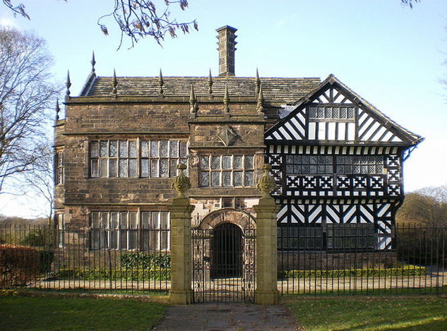
Hall i' th' Wood

Hall i' th' Wood is an early 16th-century manor house in Bolton in the historic county of Lancashire and the ceremonial county of Greater Manchester, England...
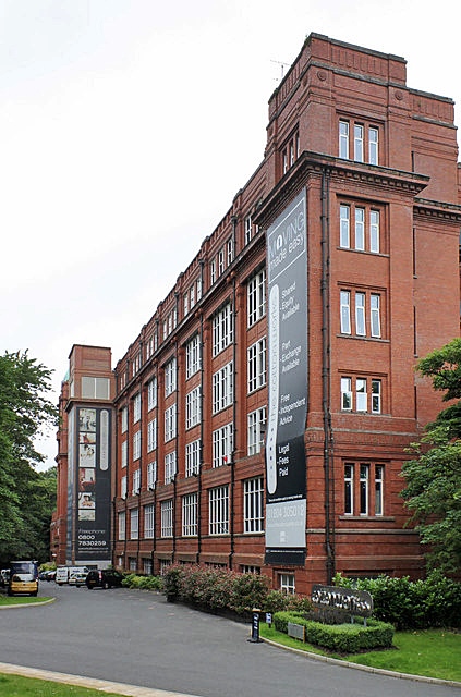
Astley Bridge Mill

Astley Bridge Mill or Holden Mill is a former cotton mill in the district of Astley Bridge in Bolton, Greater Manchester, England, which has since been...

Nearby Amenities

Located within 500m of 53.605164,-2.420861
Bus Stop
Green Way/Tonge Head Avenue
Bus: yes
Naptan AtcoCode: 1800WA04691
Naptan Bearing: N
Naptan CommonName: Green Way/Tonge Head Avenue
Naptan Indicator: Sub Station
Naptan Landmark: SUB STATION
Naptan NaptanCode: manjwgtg
Naptan PlusbusZoneRef: MNCRPIC
Naptan ShortCommonName: Tonge Head Avenue
Naptan Street: GREEN WAY
Naptan Verified: no
Network: TfGM
Public Transport: platform
Source: naptan_import
Lat/Long: 53.6014598/-2.416689
Bus Stop
Thornham Drive/Hadleigh Close
Bus: yes
Naptan AtcoCode: 1800WA13601
Naptan Bearing: E
Naptan CommonName: Thornham Drive/Hadleigh Close
Naptan Indicator: Os House 100
Naptan Landmark: HOUSE 108
Naptan NaptanCode: manpagwm
Naptan PlusbusZoneRef: MNCRPIC
Naptan ShortCommonName: Hadleigh Close
Naptan Street: THORNHAM DRIVE
Naptan Verified: no
Network: TfGM
Public Transport: platform
Source: naptan_import
Lat/Long: 53.609474/-2.4206681
Bus Stop
Ashworth Lane/Thornham Drive
Bus: yes
Naptan AtcoCode: 1800WA13621
Naptan Bearing: E
Naptan CommonName: Ashworth Lane/Thornham Drive
Naptan Indicator: O/s House 255
Naptan Landmark: HOUSE 255
Naptan NaptanCode: manpagwt
Naptan PlusbusZoneRef: MNCRPIC
Naptan ShortCommonName: Thornham Drive
Naptan Street: ASHWORTH LANE
Naptan Verified: no
Network: TfGM
Public Transport: platform
Source: naptan_import
Lat/Long: 53.6055893/-2.4211131
Bus Stop
Ashworth Lane/Eleanor Street
Bus: yes
Naptan AtcoCode: 1800WA13631
Naptan Bearing: W
Naptan CommonName: Ashworth Lane/Eleanor Street
Naptan Indicator: Op Thingies
Naptan Landmark: OP THINGIES
Naptan NaptanCode: manpajad
Naptan PlusbusZoneRef: MNCRPIC
Naptan ShortCommonName: Eleanor Street
Naptan Street: ASHWORTH LANE
Naptan Verified: no
Network: TfGM
Public Transport: platform
Source: naptan_import
Lat/Long: 53.605352/-2.4221536
Bus Stop
Ashworth Lane/Prestbury Road
Bus: yes
Naptan AtcoCode: 1800WA13641
Naptan Bearing: E
Naptan CommonName: Ashworth Lane/Prestbury Road
Naptan Indicator: Os House 223
Naptan Landmark: HOUSE 223
Naptan NaptanCode: manpajag
Naptan PlusbusZoneRef: MNCRPIC
Naptan ShortCommonName: Prestbury Road
Naptan Street: ASHWORTH LANE
Naptan Verified: no
Network: TfGM
Public Transport: platform
Source: naptan_import
Lat/Long: 53.6054551/-2.4234997
Bus Stop
Ashworth Lane/Whitegate Drive
Bus: yes
Naptan AtcoCode: 1800WA13651
Naptan Bearing: E
Naptan CommonName: Ashworth Lane/Whitegate Drive
Naptan Indicator: Op Openland
Naptan Landmark: HOUSE 65
Naptan NaptanCode: manpajaj
Naptan PlusbusZoneRef: MNCRPIC
Naptan ShortCommonName: Whitegate Drive
Naptan Street: ASHWORTH LANE
Naptan Verified: no
Network: TfGM
Public Transport: platform
Source: naptan_import
Lat/Long: 53.6052977/-2.4273217
Bus Stop
Ashworth Lane/Whitegate Drive
Bus: yes
Naptan AtcoCode: 1800WA13661
Naptan Bearing: W
Naptan CommonName: Ashworth Lane/Whitegate Drive
Naptan Indicator: Op House 61
Naptan Landmark: HOUSE 61
Naptan NaptanCode: manpajam
Naptan PlusbusZoneRef: MNCRPIC
Naptan ShortCommonName: Whitegate Drive
Naptan Street: ASHWORTH LANE
Naptan Verified: no
Network: TfGM
Public Transport: platform
Source: naptan_import
Lat/Long: 53.605189/-2.4275473
Bank Top Brewery
Addr City: Bolton
Addr Postcode: BL1 8RA
Addr Street: The Pavilion
Craft: brewery
Phone: +44 1204 595800
Website: https://www.banktopbrewery.com/
Lat/Long: 53.6047576/-2.4224753
Barrier: cycle_barrier
Foot: yes
Wheelchair: limited
Lat/Long: 53.6062728/-2.4270003
Noexit: yes
Lat/Long: 53.6056441/-2.4228112
Barrier: bollard
Lat/Long: 53.6053152/-2.4224018
Post Box
Lat/Long: 53.6051935/-2.428366
Waste Basket
Lat/Long: 53.6051603/-2.428393
Post Box
Lat/Long: 53.6054937/-2.4223081
Traffic Calming: hump
Lat/Long: 53.601899/-2.4159926
Turning Circle
Lat/Long: 53.6015726/-2.4170849
Traffic Calming: hump
Lat/Long: 53.6016902/-2.4164348
Barrier: cycle_barrier
Bicycle: dismount
Foot: yes
Horse: no
Motor Vehicle: no
Lat/Long: 53.6062885/-2.4166142
The data included in this document is from www.openstreetmap.org. The data is made available under ODbL.

Have you been to Bank Top?

Leave your review of Bank Top below (or comments, questions and feedback).