Coomb Hill

Hill, Mountain in Peeblesshire

Scotland

Coomb Hill

Southern slopes of Gathersnow Hill A view from near the summit of Hillshaw Head.
Southern slopes of Gathersnow Hill Credit: Alan O'Dowd

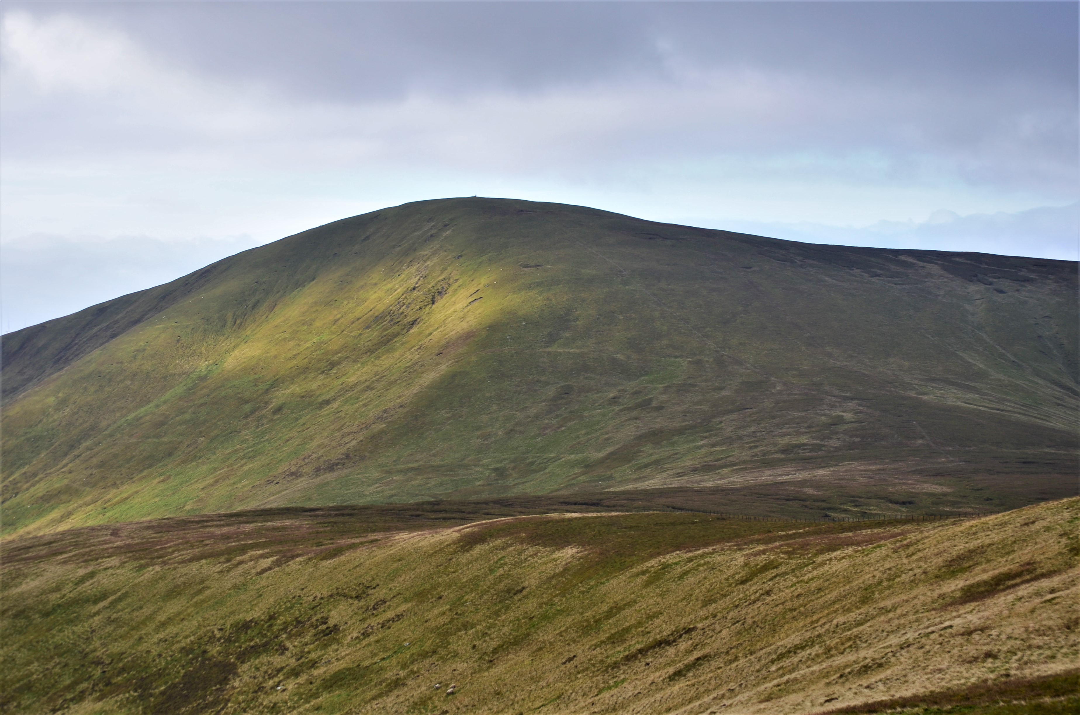
Coomb Hill is a prominent hill located in Peeblesshire, Scotland. Standing at an elevation of approximately 592 meters (1,942 feet), it is often referred to as a mountain due to its impressive height and majestic appearance.

Situated within the picturesque Tweeddale region, Coomb Hill offers breathtaking panoramic views of the surrounding countryside. The hill is part of the Moffat Hills range, which stretches across the Scottish Borders and Dumfries and Galloway. Its location makes it an ideal destination for outdoor enthusiasts, hikers, and nature lovers.

The terrain of Coomb Hill is mainly composed of heather-covered moorland and grassy slopes. The hill's summit is adorned with a cairn, a man-made pile of stones traditionally used to mark a significant point. This cairn acts as a focal point for those reaching the top, providing a sense of achievement and a spot for visitors to rest and take in the breathtaking vistas.

Access to Coomb Hill is relatively straightforward, with various footpaths and trails leading to its summit. These routes offer a range of difficulty levels, catering to both experienced hikers and casual walkers. Along the way, visitors may encounter a diverse array of wildlife, including red grouse, mountain hares, and various bird species.

Coomb Hill is a popular destination for outdoor activities such as hillwalking, birdwatching, and photography. Its commanding presence and stunning views make it a must-visit location for anyone exploring the natural beauty of Peeblesshire and the wider Scottish region.

If you have any feedback on the listing, please let us know in the comments section below.

Coomb Hill Images

Images are sourced within 2km of 55.522095/-3.4753601 or Grid Reference NT0626. Thanks to Geograph Open Source API. All images are credited.

Southern slopes of Gathersnow Hill A view from near the summit of Hillshaw Head.
Southern slopes of Gathersnow Hill
A view from near the summit of Hillshaw Head.
Looking down Glenwhappen Rig View down the hillside with Culter Fell and Chapelgill Hill in the background.
Looking down Glenwhappen Rig
View down the hillside with Culter Fell and Chapelgill Hill in the background.
Glenwhappen Rig Fence junction on the hill.
Glenwhappen Rig
Fence junction on the hill.
Summit area of Gathersnow Hill Quite an indistinct summit marker for a Graham.
Summit area of Gathersnow Hill
Quite an indistinct summit marker for a Graham.
Hills around Glenkirk from the air Glenkirk and Glencotho are near the centre of the photo. Glenkerie wind farm can be seen on the right.
Hills around Glenkirk from the air
Glenkirk and Glencotho are near the centre of the photo. Glenkerie wind farm can be seen on the right.
Glenlood Hill from the air Glenkerie wind farm can be seen on the south east slope of the hill.
Glenlood Hill from the air
Glenkerie wind farm can be seen on the south east slope of the hill.
Kingledores Burn & Kingle Rig Windfarm View down the valley of the Kingledores Burn and the Kingle Rig windfarm from the old path over from Tweedsmuir. The white house is called Hopehead. I have always wondered what the correct pronunciation of Kingledores is; King-le-dores or Kingle-dores or maybe Kin-Gledores?
Kingledores Burn & Kingle Rig Windfarm
View down the valley of the Kingledores Burn and the Kingle Rig windfarm from the old path over from Tweedsmuir. The white house is called Hopehead. I have always wondered what the correct pronunciation of Kingledores is; King-le-dores or Kingle-dores or maybe Kin-Gledores?
Track from Coulter Reservoir near Holm Nick Looking towards Coulter Reservoir
Track from Coulter Reservoir near Holm Nick
Looking towards Coulter Reservoir
Heather hillside on Coomb Hill Looking towards Holms Burn and Chapelgill Hill
Heather hillside on Coomb Hill
Looking towards Holms Burn and Chapelgill Hill
Looking down to Glengary Knowe from Coomb Hill On the east side of Coomb Hill
Looking down to Glengary Knowe from Coomb Hill
On the east side of Coomb Hill
Old Fence Posts on Glenwhappen Rig On the east side of Gathersnow Hill
Old Fence Posts on Glenwhappen Rig
On the east side of Gathersnow Hill
Fence on Gathersnow Hill On the west side going down to Fingland Moss
Fence on Gathersnow Hill
On the west side going down to Fingland Moss
View down the valley of the Holms Water On the way up to Gathersnow Hill.  Slightly further uphill some wind turbines come into sight and spoil the view.
View down the valley of the Holms Water
On the way up to Gathersnow Hill. Slightly further uphill some wind turbines come into sight and spoil the view.
Crane section and turbines, Glenkerie wind farm Liebherr crane sections on a trailer awaiting transport, now that the turbines have been installed. 
The Glenkerie wind farm comprises 11 turbines each rated at 2 MW capacity, operated by Novera Energy plc. Construction took place in 2010-11 by I & H Brown Ltd.
Crane section and turbines, Glenkerie wind farm
Liebherr crane sections on a trailer awaiting transport, now that the turbines have been installed. The Glenkerie wind farm comprises 11 turbines each rated at 2 MW capacity, operated by Novera Energy plc. Construction took place in 2010-11 by I & H Brown Ltd.
Glenkerie wind farm boundary, Broomy Law At the fence crossing the col between Glenlood Hill and Broomy Law.

The Glenkerie wind farm comprises 11 turbines each rated at 2 MW capacity, operated by Novera Energy plc. Construction took place in 2010-11 by I & H Brown Ltd.
Glenkerie wind farm boundary, Broomy Law
At the fence crossing the col between Glenlood Hill and Broomy Law. The Glenkerie wind farm comprises 11 turbines each rated at 2 MW capacity, operated by Novera Energy plc. Construction took place in 2010-11 by I & H Brown Ltd.
Glenkerie wind farm from Broomy Law Nine of the eleven turbines are in view, with the pointed top of Worm Hill L of centre. 

The Glenkerie wind farm comprises 11 turbines each rated at 2 MW capacity, operated by Novera Energy plc. Construction took place in 2010-11 by I & H Brown Ltd.
Glenkerie wind farm from Broomy Law
Nine of the eleven turbines are in view, with the pointed top of Worm Hill L of centre. The Glenkerie wind farm comprises 11 turbines each rated at 2 MW capacity, operated by Novera Energy plc. Construction took place in 2010-11 by I & H Brown Ltd.
Broomy Law summit fence Coomb Hill in view, the next top along the ridge.
Broomy Law summit fence
Coomb Hill in view, the next top along the ridge.
Coomb Hill from Broomy Law The sweep of the E side of Coomb Hill down towards the valley of the Kingledoors Burn.
Coomb Hill from Broomy Law
The sweep of the E side of Coomb Hill down towards the valley of the Kingledoors Burn.
Show me another place!

Coomb Hill is located at Grid Ref: NT0626 (Lat: 55.522095, Lng: -3.4753601)

Unitary Authority: The Scottish Borders

Police Authority: The Lothians and Scottish Borders

What 3 Words

///list.emulated.hurray. Near Biggar, South Lanarkshire

Nearby Locations

Coomb Hill

Related Wikis

Gathersnow Hill

Gathersnow Hill is a hill in the Culter Hills range, part of the Southern Uplands of Scotland. It lies west of the village of Tweedsmuir on the border...

Culter Fell

Culter Fell is a hill in the Culter Hills range, part of the Southern Uplands of Scotland. It is the county top of the historic county of Lanarkshire,...

Oliver Castle

Oliver Castle was a medieval tower house, located in upper Tweedsdale in the Scottish Borders. The site of the hillfort known as Oliver Castle is to the...

Tweedsmuir

Tweedsmuir (Scottish Gaelic: Sliabh Thuaidh) is a village and civil parish in Tweeddale, the Scottish Borders Council district, southeastern Scotland....

Nearby Amenities

Located within 500m of 55.522095,-3.4753601
Coomb Hill
Ele: 639
Ele Ft: 2097
Natural: peak
Lat/Long: 55.522196/-3.4753847
The data included in this document is from www.openstreetmap.org. The data is made available under ODbL.

Have you been to Coomb Hill?

Leave your review of Coomb Hill below (or comments, questions and feedback).