Bryn Gwyn

Hill, Mountain in Montgomeryshire

Wales

Bryn Gwyn

An imaginary bridleway My brother warned me that he'd been here before, and that he'd struggled to follow a clear route across this bit of moor, but I did rather expect to find a few clues as to where the right of way runs. I was disappointed - there's absolutely nothing on the ground at all in the way of clues, apart from a few random sheep tracks.
An imaginary bridleway Credit: Richard Law

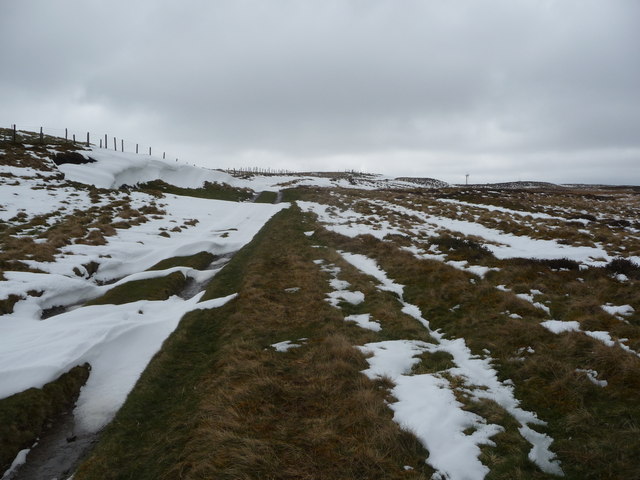
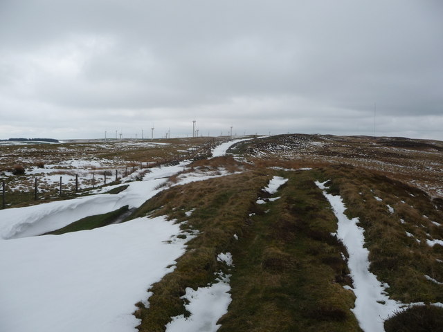
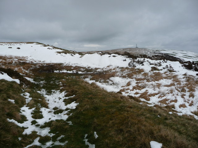
Bryn Gwyn is a prominent hill located in the county of Montgomeryshire, Wales. It forms part of the magnificent Cambrian Mountain range, which stretches across central Wales. Rising to an impressive height of around 558 meters (1831 feet), Bryn Gwyn offers breathtaking panoramic views of the surrounding countryside.

The hill is covered in lush green vegetation, with patches of heather and bracken dotting its slopes. Its rugged terrain adds to its charm, making it a popular destination for outdoor enthusiasts and hikers seeking a challenging climb. The summit provides a fantastic vantage point, allowing visitors to admire the rolling hills, deep valleys, and meandering rivers that characterize the Montgomeryshire landscape.

Bryn Gwyn is also home to a diverse range of flora and fauna. Rare species of birds, including red kites and peregrine falcons, can often be spotted soaring above, while the hill's lower slopes are home to an array of small mammals, such as voles and shrews.

The hill is easily accessible, with several footpaths leading to its summit. These paths traverse through picturesque woodlands and open meadows, adding to the overall experience. Visitors to Bryn Gwyn can enjoy a peaceful and serene environment, far away from the hustle and bustle of urban life.

Overall, Bryn Gwyn is a captivating natural landmark in Montgomeryshire, offering visitors a chance to immerse themselves in the beauty of the Welsh countryside and appreciate the wonders of nature.

If you have any feedback on the listing, please let us know in the comments section below.

Bryn Gwyn Images

Images are sourced within 2km of 52.475385/-3.406306 or Grid Reference SO0487. Thanks to Geograph Open Source API. All images are credited.

An imaginary bridleway My brother warned me that he'd been here before, and that he'd struggled to follow a clear route across this bit of moor, but I did rather expect to find a few clues as to where the right of way runs. I was disappointed - there's absolutely nothing on the ground at all in the way of clues, apart from a few random sheep tracks.
An imaginary bridleway
My brother warned me that he'd been here before, and that he'd struggled to follow a clear route across this bit of moor, but I did rather expect to find a few clues as to where the right of way runs. I was disappointed - there's absolutely nothing on the ground at all in the way of clues, apart from a few random sheep tracks.
Up the western side of the hill A view up the grassy side of the hill to the trig point and telecoms mast
Up the western side of the hill
A view up the grassy side of the hill to the trig point and telecoms mast
Waun Hir trig point and a cairn The trig is easy to identify, and is levelled at 516.026m above Ordnance Datum Newlyun. The Bronze Age mound or cairn itself is not so clear, but the trig sits on its western side, the fence cuts right across the middle of it, and the slightly depressed area about 15ft in front of me represents the hollowed-out interior of the cairn.
Waun Hir trig point and a cairn
The trig is easy to identify, and is levelled at 516.026m above Ordnance Datum Newlyun. The Bronze Age mound or cairn itself is not so clear, but the trig sits on its western side, the fence cuts right across the middle of it, and the slightly depressed area about 15ft in front of me represents the hollowed-out interior of the cairn.
OS flush bracket S9899 - Waun Hir trig The flush bracket is fixed into the western face of the concrete trig point.
OS flush bracket S9899 - Waun Hir trig
The flush bracket is fixed into the western face of the concrete trig point.
Joining the bridleway The gates here mark the point at which a quad-track across the hill leaves/joins the landrover track on the eastern flank of Yr Allt Gethin. One of them is securely bolted; the other is easy to climb over.
Joining the bridleway
The gates here mark the point at which a quad-track across the hill leaves/joins the landrover track on the eastern flank of Yr Allt Gethin. One of them is securely bolted; the other is easy to climb over.
Farm gate by a set of sheep pens The gate lies right across the descent of a fast bridleway, breaking the flow on a bike, but it obviously has a purpose to prevent sheep straying all over the hillside. Moel Iart in <a href="https://www.geograph.org.uk/gridref/SO0488">SO0488</a> above Llandinam forms most of the middle distance.
Farm gate by a set of sheep pens
The gate lies right across the descent of a fast bridleway, breaking the flow on a bike, but it obviously has a purpose to prevent sheep straying all over the hillside. Moel Iart in SO0488 above Llandinam forms most of the middle distance.
Gateway immediately east of Waen-llwydion The gateway marks the bottom end of the unsurfaced bridleway descent from Yr Allt Gethin hill, the road from here onwards is tarmacked into Llandinam.
Gateway immediately east of Waen-llwydion
The gateway marks the bottom end of the unsurfaced bridleway descent from Yr Allt Gethin hill, the road from here onwards is tarmacked into Llandinam.
Sheep pens and tracks by Waen-llwydion farm
Gate at Lower Cwm-ffrwyd The gate blocks the lane up to Wae-llwydion and a number of other small-holdings and farms in the cwm below Bryn Gwyn
Gate at Lower Cwm-ffrwyd
The gate blocks the lane up to Wae-llwydion and a number of other small-holdings and farms in the cwm below Bryn Gwyn
Woodland by A470 south of Tyncoed
Sheep pasture near Llandinam The spring, as usual in the UK, has been interrupted by a return to winter in April, but these ewes seem to have everything under control.
Sheep pasture near Llandinam
The spring, as usual in the UK, has been interrupted by a return to winter in April, but these ewes seem to have everything under control.
Lane above Lower Cem-ffrwd near Llandinam A very well maintained property sits in this sheltered valley outside Llandinam.
Lane above Lower Cem-ffrwd near Llandinam
A very well maintained property sits in this sheltered valley outside Llandinam.
Quarry above Llandinam This small quarry has its very own 'Elvis rock' - someone has replicated the more famous, one-and-only true 'Elvis rock' on the A44 near Eisteddfa Gurig - heresy indeed! It is in yellow paint above the salt bin.

Good to see someone has a sense of humour. Maybe every village should have one?
Quarry above Llandinam
This small quarry has its very own 'Elvis rock' - someone has replicated the more famous, one-and-only true 'Elvis rock' on the A44 near Eisteddfa Gurig - heresy indeed! It is in yellow paint above the salt bin. Good to see someone has a sense of humour. Maybe every village should have one?
On Yr Allt Gethin near Llandinam A quad comes up here occasionally, and maybe a pony or two and I presume occasional walkers.
On Yr Allt Gethin near Llandinam
A quad comes up here occasionally, and maybe a pony or two and I presume occasional walkers.
View northwest off Yr Allt Gethin This is an excellent viewpoint, with distant views over the valley towards Caersws.
View northwest off Yr Allt Gethin
This is an excellent viewpoint, with distant views over the valley towards Caersws.
Moorland track above Yr Allt Gethin The recent April showers have fallen as snow up here and lie in drifts in places, the sort of drifts that are more often seen in the depths of winter.
Moorland track above Yr Allt Gethin
The recent April showers have fallen as snow up here and lie in drifts in places, the sort of drifts that are more often seen in the depths of winter.
Approaching the wind farm above Llandinam The wind turbines bring to mind War of the Worlds - I almost expect to see them stalk about the landscape and start trying to zap me with their lasers. 

My blood sugar level must be lower than I thought.
Approaching the wind farm above Llandinam
The wind turbines bring to mind War of the Worlds - I almost expect to see them stalk about the landscape and start trying to zap me with their lasers. My blood sugar level must be lower than I thought.
Moorland near Llandinam Beautiful wilderness in front of me. Wind farm behind me.
Moorland near Llandinam
Beautiful wilderness in front of me. Wind farm behind me.
Show me another place!

Bryn Gwyn is located at Grid Ref: SO0487 (Lat: 52.475385, Lng: -3.406306)

Unitary Authority: Powys

Police Authority: Dyfed Powys

What 3 Words

///shirt.policy.gratitude. Near Mochdre, Powys

Nearby Locations

Bryn Gwyn

Related Wikis

Penystrywad

Penystrywad is a village near Llandinam in Powys, central Wales, between Newtown and Llanidloes, located on the A470.

Llandinam

Llandinam () is a village and community in Montgomeryshire, Powys, central Wales, between Newtown and Llanidloes, located on the A470. As a community,...

Llandinam Bridge

Llandinam Bridge (Welsh: Pont Llandinam) is a single-arch cast-iron Grade II*-listed bridge located in Llandinam, Powys, Wales. Constructed in 1846, it...

Llandinam railway station

Llandinam railway station was a station serving Llandinam, Powys, on the Llanidloes and Newtown Railway (L&NR) line. The L&NR was authorised in August...

Mochdre, Powys

Mochdre () is a small village in the community of Mochdre with Penstrowed, in Montgomeryshire, Powys, Wales. == Geography == About 3 miles (4.8 km) southwest...

Mochdre with Penstrowed

Mochdre with Penstrowed (Welsh: Mochdre gyda Phenystrywaid), or just Mochdre, is a community in Montgomeryshire, Powys, Wales. The community includes Mochdre...

Broneirion

Broneirion is a Victorian house and grounds on the hillside across the River Severn from the village of Llandinam. It was built by Welsh industrialist...

Moat Lane Junction railway station

Moat Lane Junction was a railway junction in Montgomeryshire near to the village of Caersws in mid-Wales. It was the junction where the Newtown and Machynlleth...

Have you been to Bryn Gwyn?

Leave your review of Bryn Gwyn below (or comments, questions and feedback).