Harburnhead Hill
Hill, Mountain in Midlothian
Scotland
Harburnhead Hill
![Post boxes at Crosswood Redundant postboxes put to use for delivery rather than despatch. At the start of the track to Crosswood and Crosswoodburn. The A70 [Lang Whang] heads off into the distance on the left, with the sign for the left turn [B7oo8] to West Calder.](https://s1.geograph.org.uk/geophotos/02/70/52/2705225_8e2ff54e.jpg)
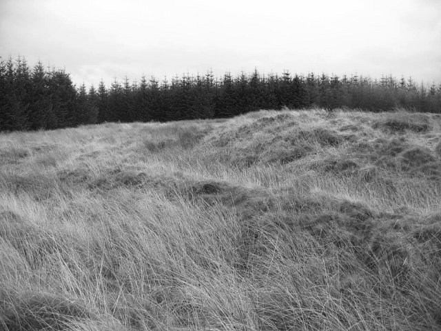
Harburnhead Hill is a prominent geographical feature located in Midlothian, Scotland. As its name suggests, it is classified as a hill rather than a mountain, standing at an elevation of approximately 276 meters (906 feet) above sea level. The hill is situated in the southwestern part of Midlothian, near the village of West Calder.
From a geological perspective, Harburnhead Hill is formed primarily of sedimentary rocks, including sandstone and shale. These rock formations have been shaped and sculpted by the forces of erosion over millions of years, resulting in the distinctive and picturesque landscape that can be observed today.
The hill is known for its diverse flora and fauna, with a range of plant and animal species calling it home. The surrounding area is covered in patches of heather and grasses, providing suitable habitats for various wildlife, including birds, small mammals, and insects.
Harburnhead Hill offers stunning panoramic views of the surrounding countryside, making it a popular destination for hikers, nature enthusiasts, and photographers. The hill is accessible via well-established walking trails, which wind their way through the rolling hills and valleys of the area.
Due to its relatively low elevation and gentle slopes, Harburnhead Hill is considered a relatively easy climb for most individuals, making it an ideal choice for those seeking a moderate outdoor activity. On a clear day, visitors can enjoy breathtaking vistas of the surrounding Midlothian landscape, including nearby hills, valleys, and farmland.
Overall, Harburnhead Hill stands as a natural landmark in Midlothian, offering a peaceful retreat for those seeking solace in nature and breathtaking views of the Scottish countryside.
If you have any feedback on the listing, please let us know in the comments section below.
Harburnhead Hill Images
Images are sourced within 2km of 55.811589/-3.5367547 or Grid Reference NT0358. Thanks to Geograph Open Source API. All images are credited.
![Aberlyn and Crosswoodburn Looking south east from the A70 [Lang Whang]. Rough grassland in the foothills of the Pentland Hills.](https://s0.geograph.org.uk/geophotos/02/70/52/2705236_91129d9b.jpg)

![Crosswood Bridge Taking the A70 [Lang Whang] over the Crosswood Burn.](https://s1.geograph.org.uk/geophotos/02/70/52/2705253_c95ac985.jpg)
![The B7008 passes through Camilty A large plantation, part of the Central Scotland Forest, now reaching maturity and being cleared nearby. Looking along the B7008 from West Calder towards the Lang Whang [A70].](https://s2.geograph.org.uk/geophotos/02/73/14/2731462_7d0842ac.jpg)


Harburnhead Hill is located at Grid Ref: NT0358 (Lat: 55.811589, Lng: -3.5367547)
Unitary Authority: West Lothian
Police Authority: The Lothians and Scottish Borders
What 3 Words
///fire.continues.prowling. Near West Calder, West Lothian
Nearby Locations
Related Wikis

Cobbinshaw Reservoir
Cobbinshaw Reservoir is a reservoir in West Lothian, Scotland. It is situated near the Pentland Hills, 5 km south of West Calder. The 310-acre (1.3 km2...
Castle Greg
Castle Greg is the archaeological remains of a Roman fortlet in Harburn on the Camilty Plantation, approximately three miles south-east of West Calder...

Cobbinshaw
Cobbinshaw is a small hamlet in West Lothian, Scotland. It is at the end of a dead end road from nearby Woolfords. Cobbinshaw is at 1,000 feet (300 m...
Cobbinshaw railway station
Cobbinshaw railway station was on the Caledonian Railway Edinburgh to Carstairs line sited near a village called Woolfords in South Lanarkshire. The freight...
Harburn, West Lothian
Harburn is a small village and estate in West Lothian, Scotland. It lies approximately 2 miles south-east of West Calder and just to the north of the Pentland...
Harburn railway station
Harburn railway station was situated on the Caledonian Railway line between Carstairs railway station and Edinburgh. It was closed in 1966 by the Beeching...
Tarbrax
Tarbrax (Scottish Gaelic: "An Tòrr Breac" - meaning "the speckled tor") is a small village in the Parish of Carnwath, South Lanarkshire, Scotland. It...
Woolfords
Woolfords is a small hamlet in the Parish of Carnwath, in South Lanarkshire, Scotland. Woolfords is located on the road between Auchengray and West Calder...
Nearby Amenities
Located within 500m of 55.811589,-3.5367547Have you been to Harburnhead Hill?
Leave your review of Harburnhead Hill below (or comments, questions and feedback).