Geal Charn

Hill, Mountain in Aberdeenshire

Scotland

Geal Charn

Cairns on the summit of Carn Bhac
Cairns on the summit of Carn Bhac Credit: Steven Brown

Geal Charn is a hill located in Aberdeenshire, Scotland. It is part of the Grampian Mountains and stands at an elevation of 821 meters (2,694 feet). Geal Charn is known for its stunning views of the surrounding countryside, including the nearby Loch Callater and Loch Muick.

The hill is a popular destination for hikers and outdoor enthusiasts, with several well-marked trails leading to the summit. The terrain is rugged and challenging, with steep slopes and rocky outcrops to navigate. The climb to the top is rewarded with panoramic views of the Scottish Highlands and the Cairngorms National Park.

Geal Charn is home to a variety of wildlife, including red deer, mountain hares, and golden eagles. The hill is also rich in plant life, with heather, bilberry, and juniper covering the slopes.

Overall, Geal Charn offers a challenging and rewarding hiking experience for those looking to explore the natural beauty of Aberdeenshire and the Scottish Highlands.

If you have any feedback on the listing, please let us know in the comments section below.
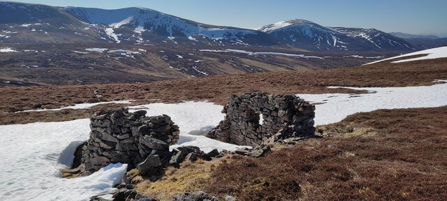
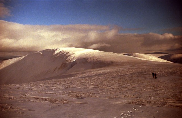
Geal Charn Images

Images are sourced within 2km of 56.931006/-3.5920906 or Grid Reference NO0383. Thanks to Geograph Open Source API. All images are credited.

Cairns on the summit of Carn Bhac
The "shelter" on Carn a' Bhutha Marked as a shelter on the 1:25,000 OS maps, its days of protecting one from the elements are obviously largely over.
The "shelter" on Carn a' Bhutha
Marked as a shelter on the 1:25,000 OS maps, its days of protecting one from the elements are obviously largely over.
Cairn on Carn Bhac A big cairn near the summit.  Ben Avon and Beinn a' Bhuird in the background.
Cairn on Carn Bhac
A big cairn near the summit. Ben Avon and Beinn a' Bhuird in the background.
On Carn Bhac Looking along the ridge from the summit with Ben a' Ghlo in the background.
On Carn Bhac
Looking along the ridge from the summit with Ben a' Ghlo in the background.
Northeast to Beinn a' Bhuird from Geal Charn Ben Avon to the right.
Northeast to Beinn a' Bhuird from Geal Charn
Ben Avon to the right.
Beinn a' Ghlo from the ridge north of Geal Charn
Pattern in the snow above Coire Bhearnaist
Coire Bhronn An important deer ground for Mar Lodge Estate, in older maps the name Coire Bhronn (or Coryvron) refers to a wider area, indicating a long lasting importance.
Coire Bhronn
An important deer ground for Mar Lodge Estate, in older maps the name Coire Bhronn (or Coryvron) refers to a wider area, indicating a long lasting importance.
Moorland near Meall Tionail
Carn Bhac View across the Allt Cristie Mòr.
Carn Bhac
View across the Allt Cristie Mòr.
Red deer below Geal Charn Although we were 1km away, this herd of deer started to move off as soon as we appeared over the ridge.
Red deer below Geal Charn
Although we were 1km away, this herd of deer started to move off as soon as we appeared over the ridge.
Summit of Carn Bhac On extreme left is The Devil's Point with Carn a' Mhaim across the Lairig Ghru from it and Sgor Mor between and in front of them.
Summit of Carn Bhac
On extreme left is The Devil's Point with Carn a' Mhaim across the Lairig Ghru from it and Sgor Mor between and in front of them.
Approaching Carn Bhac summit From the associated South West top.
Approaching Carn Bhac summit
From the associated South West top.
South West top of Carn Bhac The summit is on the right.  Coire Bhearnaist and the glen of the Allt Coire Bhearnaist lead to Inverey down in the forestry.
South West top of Carn Bhac
The summit is on the right. Coire Bhearnaist and the glen of the Allt Coire Bhearnaist lead to Inverey down in the forestry.
Summit of Geal Charn Looking through Glen Tilt.
Summit of Geal Charn
Looking through Glen Tilt.
On the north ridge of the south top of Carn Bhac The Devil's Point is prominent in the background.
On the north ridge of the south top of Carn Bhac
The Devil's Point is prominent in the background.
Summit of Geal Charn Looking north east with Inverey just beyond the forest on the left.
Summit of Geal Charn
Looking north east with Inverey just beyond the forest on the left.
Geal Charn Approaching summit shelter and cairn.
Geal Charn
Approaching summit shelter and cairn.
Show me another place!

Geal Charn is located at Grid Ref: NO0383 (Lat: 56.931006, Lng: -3.5920906)

Unitary Authority: Aberdeenshire

Police Authority: North East

What 3 Words

///repayment.blues.segments. Near Inverey, Aberdeenshire

Nearby Locations

Geal Charn

Related Wikis

Càrn Bhac

Carn Bhac (945 m) is a mountain in the Grampian Mountains of Scotland. It lies south west of the village of Inverey in Aberdeenshire, in the southern Mounth...

Loch Tilt

Loch Tilt is a small mountain freshwater loch that sits at the end of Glen Tilt and is located in north-east Perth and Kinross, Scotland. Loch Tilt has...

Beinn Iutharn Mhòr

Beinn Iutharn Mhor (1,045 m) is a mountain in the Grampian Mountains of Scotland. It lies north of Glen Shee on the Aberdeenshire and Perthshire border...

Places, place names, and structures on Mar Lodge Estate

Mar Lodge Estate is the largest remnant of the ancient Earldom of Mar in Aberdeenshire, Scotland and is now owned by the National Trust for Scotland....

Nearby Amenities

Located within 500m of 56.931006,-3.5920906
Geal Chàrn
Ele: 875
Natural: peak
Lat/Long: 56.9309215/-3.5924978
The data included in this document is from www.openstreetmap.org. The data is made available under ODbL.

Have you been to Geal Charn?

Leave your review of Geal Charn below (or comments, questions and feedback).