Connigar Hill

Hill, Mountain in Devon Mid Devon

England

Connigar Hill

Sampford Peverell : Grassy Field & Sheep A grassy field with sheep.
Sampford Peverell : Grassy Field & Sheep Credit: Lewis Clarke

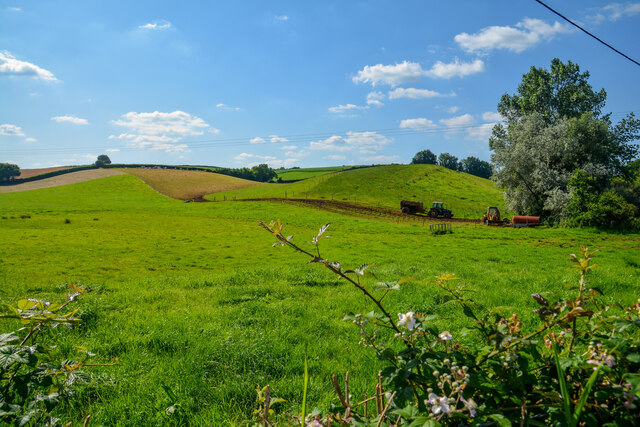
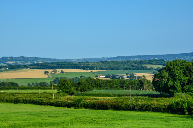
Connigar Hill is a prominent hill located in the county of Devon, England. This hill is situated in the Dartmoor National Park, which is known for its stunning natural landscapes and rugged terrain. Standing at an elevation of approximately 1,443 feet (440 meters), Connigar Hill offers breathtaking panoramic views of the surrounding countryside.

The hill is characterized by its distinctive conical shape, which gives it a unique appearance amidst the rolling hills of the region. It is predominantly covered in heather and grass, creating a picturesque sight, especially during the summer months when the hillside is adorned with vibrant colors. The hill's slopes are relatively steep and can provide a challenging hike for outdoor enthusiasts, offering a rewarding experience for those who reach the summit.

Connigar Hill is a popular destination for walkers, hikers, and nature lovers, thanks to its accessibility and the beauty of its surroundings. It is also a common spot for birdwatching, as the hill attracts a variety of bird species, including skylarks and stonechats. The area around Connigar Hill is home to a diverse range of flora and fauna, adding to its ecological significance.

Visitors to Connigar Hill can take advantage of the numerous footpaths and trails that crisscross the hillside, allowing for exploration of the surrounding area. The hill offers an ideal vantage point for taking in the breathtaking views of the nearby tors, moorland, and valleys. Connigar Hill is a must-visit destination for those seeking a peaceful escape into the natural beauty of Devon's countryside.

If you have any feedback on the listing, please let us know in the comments section below.

Connigar Hill Images

Images are sourced within 2km of 50.923981/-3.3835611 or Grid Reference ST0214. Thanks to Geograph Open Source API. All images are credited.

Sampford Peverell : Grassy Field & Sheep A grassy field with sheep.
Sampford Peverell : Grassy Field & Sheep
A grassy field with sheep.
Sampford Peverell : Whitnage Road Looking along Whitnage Road.
Sampford Peverell : Whitnage Road
Looking along Whitnage Road.
Sampford Peverell : Park People enjoy a sunny afternoon on the benches in the park.
Sampford Peverell : Park
People enjoy a sunny afternoon on the benches in the park.
Sampford Peverell : Park A park area with benches.
Sampford Peverell : Park
A park area with benches.
Sampford Peverell : Phone Booth A phone booth now used as a book swap centre.
Sampford Peverell : Phone Booth
A phone booth now used as a book swap centre.
Sampford Peverell : Daffodils The daffodils brightening up the entrance into Sampford Peverell.
Sampford Peverell : Daffodils
The daffodils brightening up the entrance into Sampford Peverell.
The Penzance to Paddington train arriving at Tiverton Parkway
Sampford Peverell : North Devon Link Road A361 An accident has taken place on the link road.
Sampford Peverell : North Devon Link Road A361
An accident has taken place on the link road.
Sampford Peverell : North Devon Link Road A361 Traffic queuing following a collision on the road.
Sampford Peverell : North Devon Link Road A361
Traffic queuing following a collision on the road.
Sampford Peverell : Turnpike House A house on Turnpike with a Tardis and Doctor Who in the scarecrow competition.
Sampford Peverell : Turnpike House
A house on Turnpike with a Tardis and Doctor Who in the scarecrow competition.
Sampford Peverell : Higher Town A scarecrow of Superintendent Hay-Stings.
Sampford Peverell : Higher Town
A scarecrow of Superintendent Hay-Stings.
Sampford Peverell : Grassy Field Looking across the countryside.
Sampford Peverell : Grassy Field
Looking across the countryside.
Sampford Peverell : Grand Western Canal The canal and swans in Sampford Peverell.
Sampford Peverell : Grand Western Canal
The canal and swans in Sampford Peverell.
Sampford Peverell : Grand Western Canal Swans on the canal.
Sampford Peverell : Grand Western Canal
Swans on the canal.
Sampford Peverell : Grand Western Canal Swans on the canal.
Sampford Peverell : Grand Western Canal
Swans on the canal.
Sampford Peverell : Countryside Scenery Looking out across the green fields.
Sampford Peverell : Countryside Scenery
Looking out across the green fields.
Sampford Peverell : Footpath A footpath through a grassy open space.
Sampford Peverell : Footpath
A footpath through a grassy open space.
Sampford Peverell : Grand Western Canal Looking along the Grand Western Canal.
Sampford Peverell : Grand Western Canal
Looking along the Grand Western Canal.
Show me another place!

Connigar Hill is located at Grid Ref: ST0214 (Lat: 50.923981, Lng: -3.3835611)

Administrative County: Devon

District: Mid Devon

Police Authority: Devon and Cornwall

What 3 Words

///reminder.weds.campfires. Near Sampford Peverell, Devon

Related Wikis

Sampford Peverell

Sampford Peverell is a village and civil parish in Mid-Devon, England. An old Saxon settlement, it was called Sanforda in the 1086 Doomsday Book. Its current...

Holbrook Garden

Holbrook Garden is a one hectare garden outside Sampford Peverell, Tiverton, Devon, with experimental naturalistic plantings creating differing habitats...

Uplowman

Uplowman () is a village and civil parish in the Mid Devon district, in Devon, England, situated about 4 miles north-east of the town of Tiverton. The...

Ayshford

Ayshford is a hamlet and historic manor in the parish of Burlescombe in the district of Mid-Devon, Devon, England. It was anciently the seat of the de...

Tiverton Parkway railway station

Tiverton Parkway railway station is on the Bristol to Exeter line in Devon, England. Despite being named after the town of Tiverton it is actually located...

Ayshford Chapel

Ayshford Chapel is a former private chapel in the village of Ayshford, in the parish of Burlescombe, Devon, England. It is recorded in the National Heritage...

Coombe, Mid Devon

Coombe is a settlement in the English county of Devon, situated some 5 miles (8.0 km) north-east of the town of Tiverton. == External links == grid reference...

Appledore, Mid Devon

Appledore is a small village near Uffculme in Devon, England, about 7 miles (11 kilometres) east of Tiverton.Appledore was listed in the Domesday Book...

Related Videos

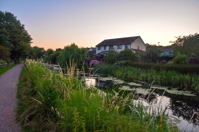
Episode 023 - Grand Western Canal Part 1

Join us as we explore the historic Grand Western Canal, starting in Tiverton. This fascinating 11 mile stretch of water has a long ...

Grand Western Canal - 2

I wander along the towpaths on the Grand Western Canal in Devon.

Reflections. Grand Western Canal. Sampford Peverell, Devon 🇬🇧

A lovely view down at the Grand Western Canal at Sampford Peverell, Devon.

Grand Western Canal - May 2nd 2021 You won’t find a prettier Parkup by the Grand Western Canal.

First night of our short break - Van parked next to the Grand Western Canal - tomorrow we're off to Somerset.

Nearby Amenities

Located within 500m of 50.923981,-3.3835611
Turning Circle
Lat/Long: 50.9235781/-3.3783127
Post Box
Post Box Type: wall
Royal Cypher: EVIIR
Royal Cypher Wikidata: Q33102324
Lat/Long: 50.9233529/-3.3769122
Telephone
Booth: K6
Covered: booth
Lat/Long: 50.9223949/-3.3790397
Barrier: stile
Lat/Long: 50.9254676/-3.3819653
Barrier: stile
Lat/Long: 50.9254853/-3.3779849
Barrier: kissing_gate
Lat/Long: 50.9253268/-3.3841364
Barrier: stile
Lat/Long: 50.9259625/-3.3840615
Bench
Backrest: no
Lat/Long: 50.9201404/-3.3804405
Give Way
Direction: backward
Lat/Long: 50.9198605/-3.38379
Give Way
Direction: forward
Lat/Long: 50.923438/-3.3767981
Barrier: stile
Lat/Long: 50.9248356/-3.3782977
Barrier: stile
Lat/Long: 50.9245124/-3.3819752
Sampford Castle
Historic: archaeological_site
Lat/Long: 50.92247/-3.385362
Information: board
Tourism: information
Lat/Long: 50.9198236/-3.384202
Direction: North
Tourism: viewpoint
Lat/Long: 50.9198208/-3.384159
Information: board
Tourism: information
Lat/Long: 50.9213427/-3.3779728
Give Way
Direction: backward
Lat/Long: 50.919629/-3.3852429
Give Way
Direction: backward
Lat/Long: 50.9199068/-3.3833962
Give Way
Direction: backward
Lat/Long: 50.919911/-3.3824078
Rest Area
Source: gps_survey;video_survey
Lat/Long: 50.9247567/-3.3842638
Generator Method: photovoltaic
Generator Output Electricity: yes
Generator Source: solar
Generator Type: solar_photovoltaic_panel
Location: roof
Power: generator
Lat/Long: 50.9243039/-3.3781162
Generator Method: photovoltaic
Generator Output Electricity: yes
Generator Source: solar
Generator Type: solar_photovoltaic_panel
Location: roof
Power: generator
Lat/Long: 50.9207169/-3.3797269
Generator Method: photovoltaic
Generator Output Electricity: yes
Generator Source: solar
Generator Type: solar_photovoltaic_panel
Location: roof
Power: generator
Lat/Long: 50.9205627/-3.3799301
Generator Method: photovoltaic
Generator Output Electricity: yes
Generator Source: solar
Generator Type: solar_photovoltaic_panel
Location: roof
Power: generator
Lat/Long: 50.9204883/-3.3794426
Generator Method: photovoltaic
Generator Output Electricity: yes
Generator Source: solar
Generator Type: solar_photovoltaic_panel
Location: roof
Power: generator
Lat/Long: 50.9223189/-3.3773732
Generator Method: photovoltaic
Generator Output Electricity: yes
Generator Source: solar
Generator Type: solar_photovoltaic_panel
Location: roof
Power: generator
Lat/Long: 50.9223705/-3.3772713
Generator Method: photovoltaic
Generator Output Electricity: yes
Generator Source: solar
Generator Type: solar_photovoltaic_panel
Location: roof
Power: generator
Lat/Long: 50.922581/-3.3768167
Generator Method: photovoltaic
Generator Output Electricity: yes
Generator Source: solar
Generator Type: solar_photovoltaic_panel
Location: roof
Power: generator
Lat/Long: 50.9225547/-3.3813456
Generator Method: photovoltaic
Generator Output Electricity: yes
Generator Source: solar
Generator Type: solar_photovoltaic_panel
Location: roof
Power: generator
Lat/Long: 50.9220944/-3.3809165
Generator Method: photovoltaic
Generator Output Electricity: yes
Generator Source: solar
Generator Type: solar_photovoltaic_panel
Location: roof
Power: generator
Lat/Long: 50.9208677/-3.3829737
Generator Method: photovoltaic
Generator Output Electricity: yes
Generator Source: solar
Generator Type: solar_photovoltaic_panel
Location: roof
Power: generator
Lat/Long: 50.9210005/-3.3823085
Generator Method: photovoltaic
Generator Output Electricity: yes
Generator Source: solar
Generator Type: solar_photovoltaic_panel
Location: roof
Power: generator
Lat/Long: 50.9197061/-3.3841941
Give Way
Direction: forward
Lat/Long: 50.9223415/-3.3793688
Give Way
Direction: backward
Lat/Long: 50.9215223/-3.3808527
Give Way
Direction: backward
Lat/Long: 50.9199295/-3.3847895
Entrance: yes
Lat/Long: 50.9196091/-3.3820074
Give Way
Direction: forward
Lat/Long: 50.9229163/-3.3779834
Give Way
Direction: forward
Lat/Long: 50.9225384/-3.3787224
Connigar Hill
Place: locality
Lat/Long: 50.9239322/-3.3844473
The data included in this document is from www.openstreetmap.org. The data is made available under ODbL.

Have you been to Connigar Hill?

Leave your review of Connigar Hill below (or comments, questions and feedback).