Beinn Mheadhoin

Hill, Mountain in Banffshire

Scotland

Beinn Mheadhoin

Beach on Loch Avon
Beach on Loch Avon Credit: Steven Brown

Beinn Mheadhoin, also known as Ben Macdui, is a prominent mountain located in the Cairngorms National Park in Banffshire, Scotland. Standing at an impressive height of 1,309 meters (4,295 feet), it is the second highest peak in the United Kingdom, surpassed only by its neighboring mountain, Cairn Gorm.

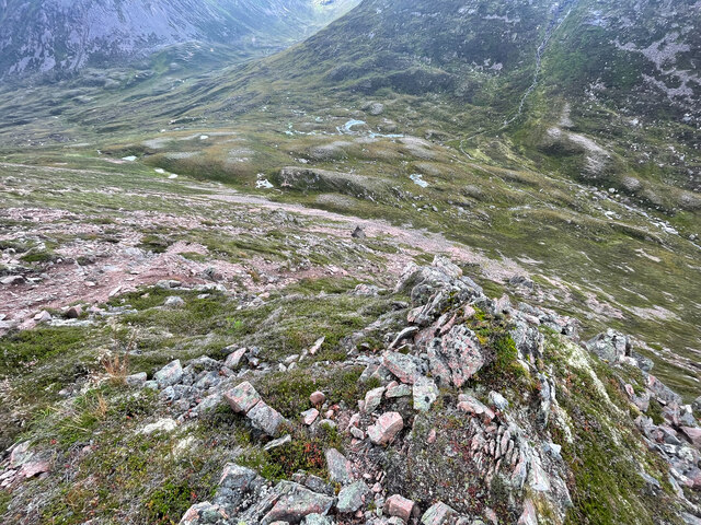
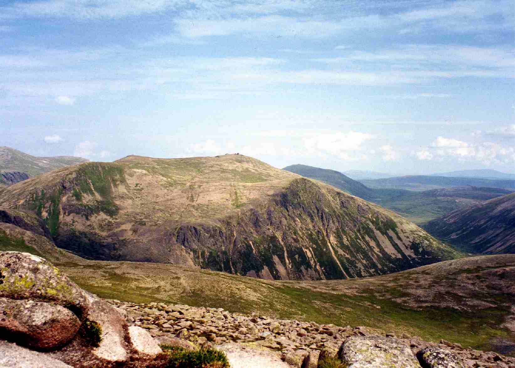
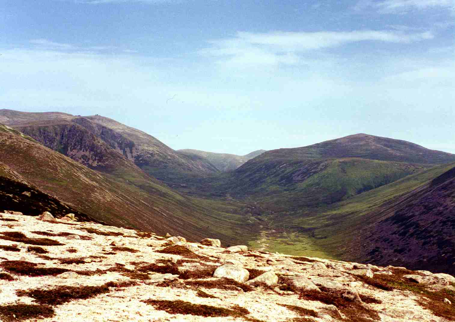
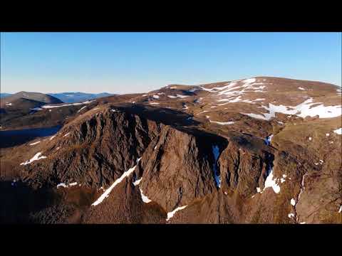
Beinn Mheadhoin is part of a range of mountains known as the Cairngorms, which are renowned for their rugged and wild beauty. The mountain boasts a distinctive pyramid-like shape with steep slopes and rocky terrain. It is composed mainly of granite, which gives it a unique appearance and makes it a popular destination for mountaineers and hikers.

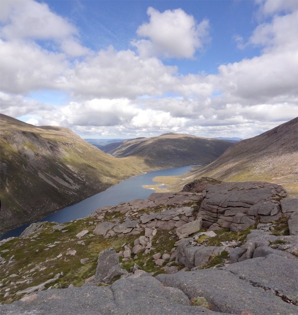
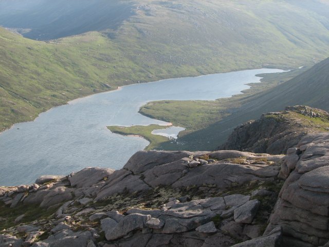
The summit of Beinn Mheadhoin offers breathtaking panoramic views of the surrounding landscape, including the vast plateaus, deep glens, and numerous other peaks of the Cairngorms. On a clear day, it is even possible to catch a glimpse of the North Sea in the distance.

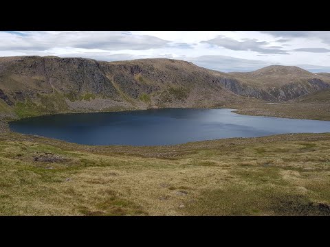
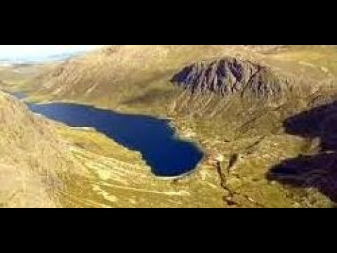
The mountain is home to a diverse range of flora and fauna, with rare species such as ptarmigan, mountain hare, and the elusive Scottish wildcat inhabiting its slopes. The surrounding area also features several picturesque lochs, including Loch Etchachan and Loch Avon, which add to the natural beauty of the region.

Beinn Mheadhoin attracts outdoor enthusiasts throughout the year, with activities such as hiking, climbing, and skiing being popular in different seasons. The mountain's challenging terrain and unpredictable weather conditions make it suitable for experienced adventurers, while its natural beauty and tranquility provide a rewarding experience for all who visit.

If you have any feedback on the listing, please let us know in the comments section below.

Beinn Mheadhoin Images

Images are sourced within 2km of 57.095851/-3.6114493 or Grid Reference NJ0201. Thanks to Geograph Open Source API. All images are credited.

Beach on Loch Avon
Beach on Loch Avon
Path towards Loch Etchachan
Path near Loch Etchachan
Barn on Beinn Mheadhoin Barns in the Cairngorms are what are known as tors elsewhere.
Barn on Beinn Mheadhoin
Barns in the Cairngorms are what are known as tors elsewhere.
Barns of Beinn Mheadhoin
Summit area of Beinn Mheadhoin
From step descent to step ascent
Cairngorm Mountains Thanks to GPS, I can be sure exactly where this was taken from, but I am less certain about what it shows. The loch is Loch Avon, so Cairn Gorm mustr be hidden in the cloud. The river is the River Avon, and the conical mountain on the left will be Beinn a' Chaorainn. Taken from a motor glider.
Cairngorm Mountains
Thanks to GPS, I can be sure exactly where this was taken from, but I am less certain about what it shows. The loch is Loch Avon, so Cairn Gorm mustr be hidden in the cloud. The river is the River Avon, and the conical mountain on the left will be Beinn a' Chaorainn. Taken from a motor glider.
The path to Loch Avon The path from Strath Nethy begins its descent from the Saddle. Carn Etchachan can be seen ahead, with the distinctive Shelter Stone Crag to its right. Slopes descending from Beinn Mheadhoin can be seen on the left.
The path to Loch Avon
The path from Strath Nethy begins its descent from the Saddle. Carn Etchachan can be seen ahead, with the distinctive Shelter Stone Crag to its right. Slopes descending from Beinn Mheadhoin can be seen on the left.
Descent to the Loch Descending the steep path beside the Allt Coire Raibeirt to the sparkling turquoise waters of Loch Avon.
Descent to the Loch
Descending the steep path beside the Allt Coire Raibeirt to the sparkling turquoise waters of Loch Avon.
Loch Avon Looking east to Loch Avon and the slopes of Beinn Mheadhoin on a lovely early autumn day.
Loch Avon
Looking east to Loch Avon and the slopes of Beinn Mheadhoin on a lovely early autumn day.
Heading to Loch Avon Magnificent mountain scenery looking to the western end of Loch Avon with Carn Etchachan and the Shelter Stone Crag towering above.
Heading to Loch Avon
Magnificent mountain scenery looking to the western end of Loch Avon with Carn Etchachan and the Shelter Stone Crag towering above.
Beach Bums Nearly 60 miles from the sea and there is a lovely sandy beach to walk on at the western end of Loch Avon.
Beach Bums
Nearly 60 miles from the sea and there is a lovely sandy beach to walk on at the western end of Loch Avon.
View from Stacan Dubha Standing atop the rocky promontory of Stacan Dubha, it is a long drop to Loch Avon. In the distance is the munro of Bynack More.
View from Stacan Dubha
Standing atop the rocky promontory of Stacan Dubha, it is a long drop to Loch Avon. In the distance is the munro of Bynack More.
A Celebration A friends second round of munros has come to an end. After the hard work a celebratory glass of bubbly and a wee dram await! Summit tor of Beinn Mheadhoin.
A Celebration
A friends second round of munros has come to an end. After the hard work a celebratory glass of bubbly and a wee dram await! Summit tor of Beinn Mheadhoin.
Into the Great Wide Open Looking west across the vast summit plateau of Beinn Mheadhoins summit tor. Ben Macdui, Scotlands 2nd highest mountain is the peak at top centre of the picture. An idea of scale can be gleaned from the figures in front of the smaller left tor.
Into the Great Wide Open
Looking west across the vast summit plateau of Beinn Mheadhoins summit tor. Ben Macdui, Scotlands 2nd highest mountain is the peak at top centre of the picture. An idea of scale can be gleaned from the figures in front of the smaller left tor.
Stepping Stones At the outflow of Loch Etchachan a walker concentrates carefully on not getting his feet wet. Creagan a' Choire Etchachan is the peak behind.
Stepping Stones
At the outflow of Loch Etchachan a walker concentrates carefully on not getting his feet wet. Creagan a' Choire Etchachan is the peak behind.
Into the Glen From the summit of Stob Coire Etchachan looking across to Sgurr an Lochan Uaine <a title="https://www.geograph.org.uk/photo/2598325" href="https://www.geograph.org.uk/photo/2598325">Link</a> and the very upper reaches of Glen Derry.
Into the Glen
From the summit of Stob Coire Etchachan looking across to Sgurr an Lochan Uaine Link and the very upper reaches of Glen Derry.
Show me another place!

Beinn Mheadhoin is located at Grid Ref: NJ0201 (Lat: 57.095851, Lng: -3.6114493)

Unitary Authority: Moray

Police Authority: North East

What 3 Words

///daunted.output.shorthand. Near Inverey, Aberdeenshire

Nearby Locations

Beinn Mheadhoin

Related Wikis

Beinn Mheadhoin (Cairngorms)

Beinn Mheadhoin or Beinn Meadhain (Scottish Gaelic for 'middle mountain') is a mountain in the Highlands of Scotland. It is a Munro with a height of 1...

Cairngorm Lochs

Cairngorm Lochs is a protected wetland area in the Cairngorms, in the Grampian and Highland regions of Scotland. With a total area of 173 hectares, it...

Loch A'an

Loch A'an is a remote freshwater loch set deep within the central Cairngorms plateau, in the Cairngorms National Park, located in the eastern Highlands...

Lairig an Laoigh

The Lairig an Laoigh ( LAR-ig ən LOO-ee; Scottish Gaelic: Làirig Laoigh) is a mountain pass through the Highlands of Scotland. In speech and sometimes...

Beinn a' Chaorainn (Cairngorms)

Beinn a' Chaorainn is a Scottish mountain in the heart of the Cairngorms range. It is quite a remote hill, being located roughly 19 kilometres south east...

Loch Etchachan

Loch Etchachan is a remote freshwater loch set deep within the central Cairngorms plateau, in the Cairngorms National Park, located in the eastern Highlands...

Cairn Gorm

Cairn Gorm (Scottish Gaelic: An Càrn Gorm) is a mountain in the Scottish Highlands. It is part of the Cairngorms range and wider Grampian Mountains. With...

Ly Erg

The Ly Erg is a fairy from Scottish folklore, particularly associated with the area in and around the Glenmore Forest, part of the present-day Cairngorms...

Related Videos

SNOW WILD CAMP up CAIRN GORM [1/3]

I had some time off courier work so travelled up to Scotland with Jack where we met up with a few friends for three nights of wild ...

The Cairngorm's and Shelterstone at Dawn

An edit of some of the dawn photos and video I took on an overnight bivvy trip on the Cairngorm and Ben MaDui plateau on the ...

Summer Loch A'an On Visit To The Eastern Highlands Of Scotland

Tour Scotland Summer travel video, with Scottish music, of Loch A'an on visit to the Eastern Highlands. Loch A'an is a remote ...

Nearby Amenities

Located within 500m of 57.095851,-3.6114493
Beinn Mheadhoin
Description: Middle hill
Ele: 1182
Marilyn: yes
Munro: yes
Munro Number: M013
Natural: peak
Prominence: 254
Source: survey
Wikidata: Q814812
Wikipedia: en:Beinn Mheadhoin (Cairngorms)
Lat/Long: 57.0959339/-3.611476
The data included in this document is from www.openstreetmap.org. The data is made available under ODbL.

Have you been to Beinn Mheadhoin?

Leave your review of Beinn Mheadhoin below (or comments, questions and feedback).