Bad an Tuirc

Hill, Mountain in Perthshire

Scotland

Bad an Tuirc

Shooters' hut The track from Tarvie continues slightly beyond this hut, although this isn't shown on the map.
Shooters' hut Credit: Alan O'Dowd

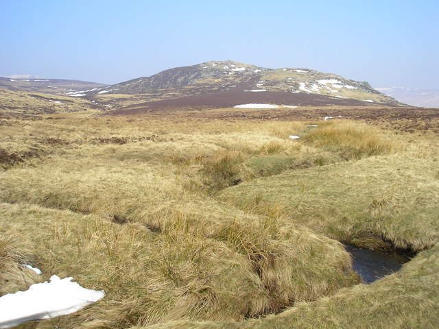
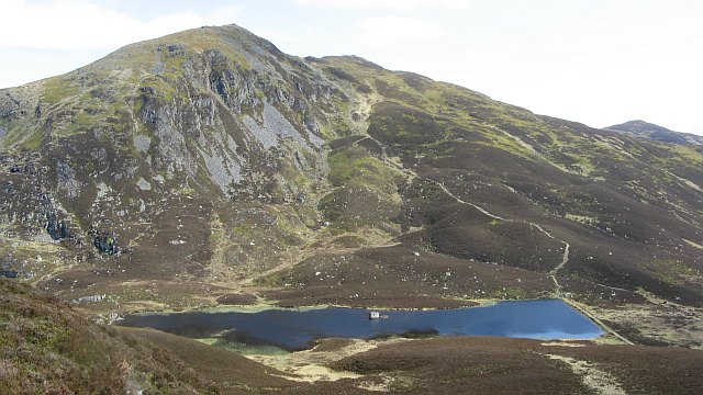
Bad an Tuirc, located in Perthshire, Scotland, is a prominent hill that stands at an elevation of approximately 750 meters. Also referred to as a mountain by some locals, it offers breathtaking views and is a popular destination for outdoor enthusiasts.

The hill is situated within the Cairngorms National Park, which is renowned for its rugged landscapes and diverse wildlife. Bad an Tuirc forms part of the Grampian Mountains, which stretch across the eastern Highlands of Scotland.

Visitors to Bad an Tuirc can expect a challenging yet rewarding ascent. The hill features steep slopes and rocky terrain, making it suitable for experienced hikers and mountaineers. The summit offers panoramic vistas of the surrounding countryside, with sweeping views of the Cairngorms and the picturesque River Dee valley.

The area surrounding Bad an Tuirc is rich in flora and fauna, attracting nature lovers from far and wide. It is home to various species of birds, including golden eagles, ptarmigans, and grouse, as well as mammals such as red deer and mountain hares. The hillside is adorned with heather, grasses, and mosses, creating a vibrant and colorful landscape.

Bad an Tuirc is easily accessible from nearby towns and villages, with several well-marked trails leading to its summit. However, caution is advised, as weather conditions can change rapidly, and appropriate clothing and equipment are necessary for a safe and enjoyable experience.

Overall, Bad an Tuirc offers a thrilling outdoor adventure and a chance to immerse oneself in the natural beauty of Perthshire's rugged terrain.

If you have any feedback on the listing, please let us know in the comments section below.

Bad an Tuirc Images

Images are sourced within 2km of 56.784882/-3.6084671 or Grid Reference NO0167. Thanks to Geograph Open Source API. All images are credited.

Shooters' hut The track from Tarvie continues slightly beyond this hut, although this isn't shown on the map.
Shooters' hut
The track from Tarvie continues slightly beyond this hut, although this isn't shown on the map.
Heather moorland near the Tarvie Burn Sunlight brings out the purple colour of the heather as a shower darkens the skies to the north.
Heather moorland near the Tarvie Burn
Sunlight brings out the purple colour of the heather as a shower darkens the skies to the north.
Heather moorland near Bad an Tuirc Backlit by sunlight while a shower passing to the north darkens the sky.
Heather moorland near Bad an Tuirc
Backlit by sunlight while a shower passing to the north darkens the sky.
Moorland track, Tarvie Estate A well-established track cutting through a swathe of heather moorland.
Moorland track, Tarvie Estate
A well-established track cutting through a swathe of heather moorland.
Track junction, Tarvie Estate The track going straight ahead here is shown on the map as a short stub which quickly peters out, whereas the main track veers round to the left.
Track junction, Tarvie Estate
The track going straight ahead here is shown on the map as a short stub which quickly peters out, whereas the main track veers round to the left.
Rolling moorland below Druim Moor Druim Moor rises to the left out of the image, the ridge of which it's a part continuing to Ben Vuirich.
The distant, snowed peak is Glas Tulaichean; the rest of the hills along the horizon are between Gleann Fearnach and Glen Lochsie.
Rolling moorland below Druim Moor
Druim Moor rises to the left out of the image, the ridge of which it's a part continuing to Ben Vuirich. The distant, snowed peak is Glas Tulaichean; the rest of the hills along the horizon are between Gleann Fearnach and Glen Lochsie.
Beinn Bhuirich from the Tarvie Burn. Moorland above Tarvie.
Beinn Bhuirich from the Tarvie Burn.
Moorland above Tarvie.
Tarvie Moor View across the Tarvie moorland to the hills on the south side of Glen Shee (Meall a'Choire Bhuidhe and Ben Earb). All hollows filled with snow.
Tarvie Moor
View across the Tarvie moorland to the hills on the south side of Glen Shee (Meall a'Choire Bhuidhe and Ben Earb). All hollows filled with snow.
Allt Uisge Allt Uisge at a prominent bend in the stream.  The break in the snow in the foreground marks the course of the stream.  A short distance beyond the patch of snow the path of the stream on the upper side of the bend can be seen.
The hill in the background is Carn Dubh, while the slope on the left is part of Meall Daimheidh.
Allt Uisge
Allt Uisge at a prominent bend in the stream. The break in the snow in the foreground marks the course of the stream. A short distance beyond the patch of snow the path of the stream on the upper side of the bend can be seen. The hill in the background is Carn Dubh, while the slope on the left is part of Meall Daimheidh.
Allt Uisge The view of Allt Uisage just beyond a prominent bend.

Creag Uisge appears in the background.
Allt Uisge
The view of Allt Uisage just beyond a prominent bend. Creag Uisge appears in the background.
Moorland View across the moorland with Carn Dubh in the background.
Moorland
View across the moorland with Carn Dubh in the background.
Moorland The view across the moor towards Creag Uisge.
Moorland
The view across the moor towards Creag Uisge.
End of the Wall and Start of the Fence The view of the end of the wall which runs from the summit of Carn Dubh down the mountain side until it stops on the relatively level ground.  There are metal fence posts mounted on the wall but the wire has gone.  However on the relatively level ground there is now a new fence (on the right of the wall) and that runs in a east south easternly direction for as far as the eye can see.
End of the Wall and Start of the Fence
The view of the end of the wall which runs from the summit of Carn Dubh down the mountain side until it stops on the relatively level ground. There are metal fence posts mounted on the wall but the wire has gone. However on the relatively level ground there is now a new fence (on the right of the wall) and that runs in a east south easternly direction for as far as the eye can see.
The meeting of two fences Looking towards Meall Daimheidh at the point where the fence on the eastern flank of Carn Dubh meets the fence which follows on the line of the wall from the summit of Carn Dubh.
The meeting of two fences
Looking towards Meall Daimheidh at the point where the fence on the eastern flank of Carn Dubh meets the fence which follows on the line of the wall from the summit of Carn Dubh.
The Summit of Meall Daimheidh The view at the summit of Meall Daimheidh with Creag Chliabhain in the background.
The Summit of Meall Daimheidh
The view at the summit of Meall Daimheidh with Creag Chliabhain in the background.
The lower slopes of Druim Cul The view towards Gleann Fearnach from the lower slopes of Druim Cul.
The lower slopes of Druim Cul
The view towards Gleann Fearnach from the lower slopes of Druim Cul.
Druim Cul The view of the forest as seen from the lower slopes of Druim Cul as the hill is skirted on its southern side.
Druim Cul
The view of the forest as seen from the lower slopes of Druim Cul as the hill is skirted on its southern side.
Stone man on Creag an t-Sìthein Prominent cairn just north of the summit of Creag an t-Sìthein.
Stone man on Creag an t-Sìthein
Prominent cairn just north of the summit of Creag an t-Sìthein.
Show me another place!

Bad an Tuirc is located at Grid Ref: NO0167 (Lat: 56.784882, Lng: -3.6084671)

Unitary Authority: Perth and Kinross

Police Authority: Tayside

What 3 Words

///pasta.crafts.laminated. Near Pitlochry, Perth & Kinross

Nearby Locations

Bad an Tuirc

Related Wikis

Ben Vuirich

Ben Vuirich (903 m) is a mountain in the Grampian Mountains of Scotland. It is located in Perthshire, north of the town of Pitlochry. A mountain of heather...

Kindrogan House

Kindrogan House is located near Enochdhu, Blairgowrie, Perth and Kinross in Moulin parish, at the head of Strath Ardle, 7 miles (11 km) ENE of Pitlochry...

Dirnanean House

Dirnanean House is part of a private, traditional Highland estate located near Enochdhu in Moulin parish, Blairgowrie, Perth and Kinross, Scotland, 10...

Balvarran

Balvarran is an old laird's house and estate in Strathardle, Perth and Kinross. It is situated to the east of the River Ardle, a mile east of Enochdhu...

Ben Vrackie

Ben Vrackie (Scottish Gaelic: Beinn a' Bhreacaidh; sometimes anglicised as Ben Y Vrackie) is a mountain in Perthshire, Scotland. It lies north of the town...

Loch Loch

Loch Loch is a remote freshwater loch, located in Glen Loch in Perth and Kinross, some 9.5 miles north of Pitlochry, Scotland and is within the Forest...

Valley of Strathmore

Strathmore (Gaelic: An Srath Mòr) is a strath in east central Scotland running from northeast to southwest between the Grampian mountains and the Sidlaws...

Càrn Liath (Munro)

Carn Liath (976 m) is a mountain in the Grampian Mountains of Scotland. It lies east of Blair Atholl in Perthshire, Scotland. Although belonging to the...

Nearby Amenities

Located within 500m of 56.784882,-3.6084671
Bad an Tuirc
Ele: 608
Natural: peak
Lat/Long: 56.7858395/-3.6078085
The data included in this document is from www.openstreetmap.org. The data is made available under ODbL.

Have you been to Bad an Tuirc?

Leave your review of Bad an Tuirc below (or comments, questions and feedback).