Turkey Hill

Hill, Mountain in Lanarkshire

Scotland

Turkey Hill

Cow Gill View down from the road.
Cow Gill Credit: Richard Webb

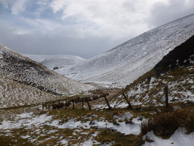
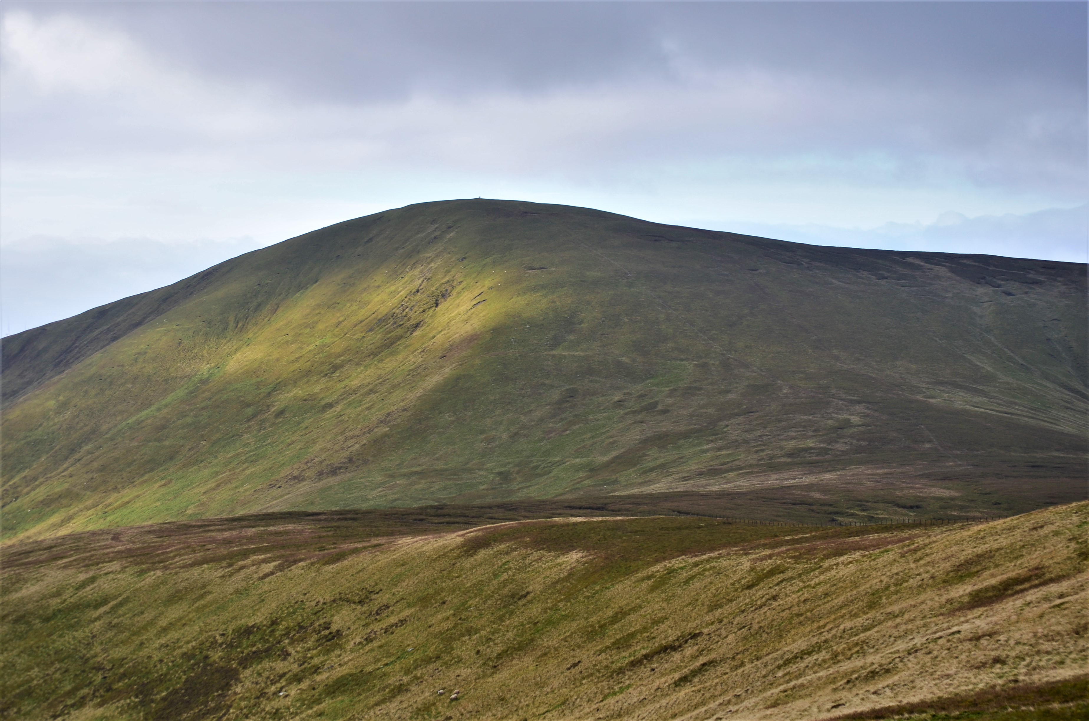
Turkey Hill is a prominent landmark located in the county of Lanarkshire, Scotland. This hill, also referred to as Turkey Mountain by some locals, is situated in the southern part of Lanarkshire, near the town of Biggar. Standing at an impressive height of approximately 450 meters (1,476 feet), it offers breathtaking views of the surrounding countryside.

Turkey Hill is characterized by its distinctive shape, with a gently sloping ascent leading to a flat summit. The hill is primarily composed of sedimentary rocks, including sandstone and shale, which contribute to its unique geological features. Its exposed rock formations provide an interesting study for geologists and nature enthusiasts alike.

The hill is rich in biodiversity, supporting a variety of flora and fauna. Visitors to Turkey Hill can expect to encounter an array of plant species, including heather, gorse, and wildflowers. The diverse habitat also attracts a range of birdlife, making it a popular destination for birdwatchers.

For outdoor enthusiasts, Turkey Hill offers several hiking trails that cater to different skill levels. The trails provide a chance to explore the hill's natural beauty up close, with panoramic vistas rewarding those who reach the summit. Adventurous climbers can also take advantage of the hill's rocky terrain to test their skills.

Overall, Turkey Hill is a cherished natural landmark in Lanarkshire, offering a tranquil escape from the hustle and bustle of everyday life. Its stunning views, geological wonders, and diverse ecosystems make it a must-visit destination for nature lovers and outdoor enthusiasts.

If you have any feedback on the listing, please let us know in the comments section below.

Turkey Hill Images

Images are sourced within 2km of 55.566899/-3.5688607 or Grid Reference NT0131. Thanks to Geograph Open Source API. All images are credited.

Cow Gill View down from the road.
Cow Gill
View down from the road.
Water board house, Cowgill View from Broad Hill.
Water board house, Cowgill
View from Broad Hill.
Track to Key Cleuch The track through Key Cleuch leaves the reservoir road here near Cowgill Cottage.
Track to Key Cleuch
The track through Key Cleuch leaves the reservoir road here near Cowgill Cottage.
Gathering the flock, Broad Hill A Blackface flock being gathered by three collies (one out of shot) on the north side of Broad Hill, seen from the track in Key Cleuch.
Gathering the flock, Broad Hill
A Blackface flock being gathered by three collies (one out of shot) on the north side of Broad Hill, seen from the track in Key Cleuch.
Key Cleuch A narrow valley between Lamington Hill and Broad Hill, and a pass between Cow Gill and Lamington in Clydesdale.
Key Cleuch
A narrow valley between Lamington Hill and Broad Hill, and a pass between Cow Gill and Lamington in Clydesdale.
Cowgill Farm The track to the right leads to Cowgill Loch and, ultimately, to the village of Lamington. Broad Hill ahead (464m).
Cowgill Farm
The track to the right leads to Cowgill Loch and, ultimately, to the village of Lamington. Broad Hill ahead (464m).
End of the road Cowgill Reservoir lies beyond
End of the road
Cowgill Reservoir lies beyond
Key Cleuch In Scots, a 'cleuch' is a narrow, steep-sided ravine. Here, it is marked by the tree line with Broad Hill to the left and Lamington Hill to the right.
Key Cleuch
In Scots, a 'cleuch' is a narrow, steep-sided ravine. Here, it is marked by the tree line with Broad Hill to the left and Lamington Hill to the right.
Road, Cowgill They have not managed to close the Cowgill road like the Culter road. The ewe and lamb was being driven by a shepherd on a quadbike behind the brow of the hill.

--
2022
Unfortunately the road has since been taken off us and is now gated with a fierce non compliant notice on it.
Road, Cowgill
They have not managed to close the Cowgill road like the Culter road. The ewe and lamb was being driven by a shepherd on a quadbike behind the brow of the hill. -- 2022 Unfortunately the road has since been taken off us and is now gated with a fierce non compliant notice on it.
Cowgill View from Broad Hill.
Cowgill
View from Broad Hill.
Cowgill The meandering stream is a missfit. A look at the map shows some deep meltwater channels cutting through the surrounding hills. They also carved this wide glen, far too wide for the small burn now flowing here.

My thanks to Anne Burgess and her geologist friends for an interesting discussion and explanation of this feature.
Cowgill
The meandering stream is a missfit. A look at the map shows some deep meltwater channels cutting through the surrounding hills. They also carved this wide glen, far too wide for the small burn now flowing here. My thanks to Anne Burgess and her geologist friends for an interesting discussion and explanation of this feature.
Cow Gill The burn downstream of the reservoirs.
Cow Gill
The burn downstream of the reservoirs.
Shank Houp Burn between two of Heatherstane Law's ridges. There are improved fields here.
Shank Houp
Burn between two of Heatherstane Law's ridges. There are improved fields here.
Key Cleuch A narrow valley between Lamington Hill and Broad Hill
Key Cleuch
A narrow valley between Lamington Hill and Broad Hill
Path through Key Cleuch A narrow valley between Lamington Hill and Broad Hill, through which Cow Gill flows.  It is sometimes called Cow Cleuch in older references.
Path through Key Cleuch
A narrow valley between Lamington Hill and Broad Hill, through which Cow Gill flows. It is sometimes called Cow Cleuch in older references.
Looking north-west through Key Cleuch This track joins up with the Nips Road track which runs down to Lamington, on the A702 Abington to Edinburgh road.
Looking north-west through Key Cleuch
This track joins up with the Nips Road track which runs down to Lamington, on the A702 Abington to Edinburgh road.
Hillside enclosure, Cowgill The track to Cowgill, with a large rectangular sheep enclosure on the lower slopes of Broad Hill.
Hillside enclosure, Cowgill
The track to Cowgill, with a large rectangular sheep enclosure on the lower slopes of Broad Hill.
Cowgill and Cowgill Rig Approaching the sheep farm at Cowgill on the Key Cleuch track. Cowgill Rig is the hill behind with a strip of forestry.
Cowgill and Cowgill Rig
Approaching the sheep farm at Cowgill on the Key Cleuch track. Cowgill Rig is the hill behind with a strip of forestry.
Show me another place!

Turkey Hill is located at Grid Ref: NT0131 (Lat: 55.566899, Lng: -3.5688607)

Unitary Authority: South Lanarkshire

Police Authority: Lanarkshire

What 3 Words

///fried.party.peach. Near Biggar, South Lanarkshire

Nearby Locations

Turkey Hill

Related Wikis

Unthank, South Lanarkshire

Unthank is a small village in South Lanarkshire, Scotland. == Note == The geographic coordinates are from the Ordnance Survey. == References ==

Coulter, South Lanarkshire

Coulter or Culter (both spellings in use, pronounced "Cooter" with no "l") is a small village and civil parish in South Lanarkshire, Scotland. It lies...

Lamington, South Lanarkshire

Lamington is a conservation village in South Lanarkshire in Scotland, roughly between Biggar and Lanark and sits astride the A702 trunk road. It is reputed...

Symington, South Lanarkshire

Symington is a small village in South Lanarkshire, Scotland, 3 miles (5 km) southwest of Biggar, 10 miles (16 km) east of Douglas and 13 miles (21 km)...

Lamington railway station

Lamington railway station served the village of Lamington, South Lanarkshire, Scotland from 1848 to 1965 on the Caledonian main line. == History == The...

A72 road

The A72 road is a major route in Scotland connecting Hamilton in South Lanarkshire, with Galashiels in the Scottish Borders. It travels for over 97 kilometres...

Culter Fell

Culter Fell is a hill in the Culter Hills range, part of the Southern Uplands of Scotland. It is the county top of the historic county of Lanarkshire,...

Coulter railway station

Coulter railway station served the village of Coulter, South Lanarkshire, Scotland from 1860 to 1965 on the Symington, Biggar and Broughton Railway....

Nearby Amenities

Located within 500m of 55.566899,-3.5688607
Turkey Hill
Corbett: no
Ele: 489
Graham: no
Munro: no
Natural: peak
Lat/Long: 55.5666986/-3.5693284
Howegill Rigg
Created By: Potlatch 0.10f
Graham: no
Munro: no
Natural: peak
Lat/Long: 55.5633982/-3.5643502
Roop Law
Created By: Potlatch 0.10f
Natural: peak
Lat/Long: 55.5674153/-3.5673666
The data included in this document is from www.openstreetmap.org. The data is made available under ODbL.

Have you been to Turkey Hill?

Leave your review of Turkey Hill below (or comments, questions and feedback).