Ben Skievie

Hill, Mountain in Perthshire

Scotland

Ben Skievie

Straloch War Memorial Celtic cross war memorial that once stood in the grounds of the parish church, now moved to a site next to the A924 near Dalnacarn.
Straloch War Memorial Credit: Scott Cormie

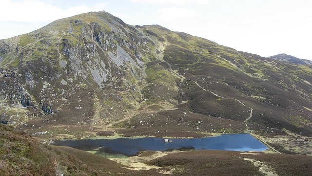
Ben Skievie is a prominent hill located in the region of Perthshire, Scotland. Standing at an elevation of 721 meters (2,365 feet), it is a popular destination for hikers, mountaineers, and nature enthusiasts. The hill is part of the Grampian Mountains, which are renowned for their scenic beauty and rugged terrain.

Ben Skievie offers stunning panoramic views of the surrounding landscape, including lush green valleys, meandering rivers, and rolling hills. On clear days, it is even possible to spot the distant peaks of the Cairngorms National Park to the north. The hill boasts a variety of terrains, from gentle slopes at the foothills to steeper sections as one ascends towards the summit.

The ascent to the top of Ben Skievie can be challenging, particularly in inclement weather conditions. However, it rewards climbers with breathtaking vistas and a sense of achievement. The hill is often accessed from nearby towns such as Pitlochry or Blair Atholl, with several well-marked trails leading to its peak.

Nature enthusiasts visiting Ben Skievie may encounter a diverse range of flora and fauna along the way. The hill is home to various species of birds, including golden eagles, peregrine falcons, and red grouse. Wildflowers such as heather and bluebells adorn the slopes, adding bursts of color to the landscape.

Overall, Ben Skievie offers a memorable outdoor experience for those seeking adventure and natural beauty. Its challenging climb and breathtaking views make it an attractive destination for outdoor enthusiasts visiting the Perthshire region.

If you have any feedback on the listing, please let us know in the comments section below.

Ben Skievie Images

Images are sourced within 2km of 56.765441/-3.6214603 or Grid Reference NO0064. Thanks to Geograph Open Source API. All images are credited.

Straloch War Memorial Celtic cross war memorial that once stood in the grounds of the parish church, now moved to a site next to the A924 near Dalnacarn.
Straloch War Memorial
Celtic cross war memorial that once stood in the grounds of the parish church, now moved to a site next to the A924 near Dalnacarn.
A924 in Glen Brerachan The A924 westbound towards Pitlochry heading through Glen Brerachan.
A924 in Glen Brerachan
The A924 westbound towards Pitlochry heading through Glen Brerachan.
Road to Tigh Cnoc and Tomchulan
Farm lasses enjoying their work
Road through Glen Brerachan
Stronhayie old farm below its crag
Strath Ardle - by Dalnavaid Downstream view from beside the A924.
Strath Ardle - by Dalnavaid
Downstream view from beside the A924.
Dalnacarn Farmland at the head of Strath Ardle. Beyond is boulder strewn moorland.
Dalnacarn
Farmland at the head of Strath Ardle. Beyond is boulder strewn moorland.
Brerachan Meadow The strip of land between the A924 road and the Brerachan Water is part of a Site of Special Scientific Interest. Brerachan Meadow is an upland hay meadow, rich in plant species, and over 500 different plants have been recorded from here.
Brerachan Meadow
The strip of land between the A924 road and the Brerachan Water is part of a Site of Special Scientific Interest. Brerachan Meadow is an upland hay meadow, rich in plant species, and over 500 different plants have been recorded from here.
Glen Brerachan
Glen Brerachan
War Memorial War Memorial in Glen Brerachan
War Memorial
War Memorial in Glen Brerachan
Hut at Tarvie Loch Tarvie Loch is along the course of the Tarvie Burn and appears to be an artificial creation; it's beside a hill road and just east of Ben Skievie. There's a boat lying on the heather above the boulders.
Hut at Tarvie Loch
Tarvie Loch is along the course of the Tarvie Burn and appears to be an artificial creation; it's beside a hill road and just east of Ben Skievie. There's a boat lying on the heather above the boulders.
Dalnacarn Farm An upland sheep farm with tree shelter.
Dalnacarn Farm
An upland sheep farm with tree shelter.
Tarvie Burn near Straloch Looking upstream.  

The burn flows into the Brerachan Water.
Tarvie Burn near Straloch
Looking upstream. The burn flows into the Brerachan Water.
Gate by Tarvie Burn The gate gives access to a farm track.
Gate by Tarvie Burn
The gate gives access to a farm track.
Footpath to Brerachan Falls The farm track allows walkers to access the path to the falls.
Footpath to Brerachan Falls
The farm track allows walkers to access the path to the falls.
Lichen on the bridge, Dalnavaid The old bridge is over Brerachan Water.

Lichens do not have roots, but absorb water and gases through their upper surface, and are therefore sensitive to atmospheric pollution.  For this reason they are rarely found around cities and grow best on the wetter west side of the British Isles.  Those on trees thrive best on the sunny, south-west aspects of trunks and branches.  Disappearance of lichen species can be used to detect rising levels of air pollution.  

There are three main types.  The encrusting forms, including the bright orange/dark yellow 'Xanthoria' grow on roofs, walls, gravestones, signs and tree trunks.  Leaf-like species develop flat lobes spreading over bark or stones, and shrubby forms which grow vertically from the ground or hang from trees.  Few have common names.
Lichen on the bridge, Dalnavaid
The old bridge is over Brerachan Water. Lichens do not have roots, but absorb water and gases through their upper surface, and are therefore sensitive to atmospheric pollution. For this reason they are rarely found around cities and grow best on the wetter west side of the British Isles. Those on trees thrive best on the sunny, south-west aspects of trunks and branches. Disappearance of lichen species can be used to detect rising levels of air pollution. There are three main types. The encrusting forms, including the bright orange/dark yellow 'Xanthoria' grow on roofs, walls, gravestones, signs and tree trunks. Leaf-like species develop flat lobes spreading over bark or stones, and shrubby forms which grow vertically from the ground or hang from trees. Few have common names.
Bridge over Brerachan Water The old bridge over the burn has been replaced by a more modern road bridge.
Bridge over Brerachan Water
The old bridge over the burn has been replaced by a more modern road bridge.
Show me another place!

Ben Skievie is located at Grid Ref: NO0064 (Lat: 56.765441, Lng: -3.6214603)

Unitary Authority: Perth and Kinross

Police Authority: Tayside

What 3 Words

///curtains.trophy.bitter. Near Pitlochry, Perth & Kinross

Nearby Locations

Ben Skievie

Related Wikis

Kindrogan House

Kindrogan House is located near Enochdhu, Blairgowrie, Perth and Kinross in Moulin parish, at the head of Strath Ardle, 7 miles (11 km) ENE of Pitlochry...

Ben Vuirich

Ben Vuirich (903 m) is a mountain in the Grampian Mountains of Scotland. It is located in Perthshire, north of the town of Pitlochry. A mountain of heather...

Dirnanean House

Dirnanean House is part of a private, traditional Highland estate located near Enochdhu in Moulin parish, Blairgowrie, Perth and Kinross, Scotland, 10...

Ben Vrackie

Ben Vrackie (Scottish Gaelic: Beinn a' Bhreacaidh; sometimes anglicised as Ben Y Vrackie) is a mountain in Perthshire, Scotland. It lies north of the town...

Valley of Strathmore

Strathmore (Gaelic: An Srath Mòr) is a strath in east central Scotland running from northeast to southwest between the Grampian mountains and the Sidlaws...

Loch Broom (Perth and Kinross)

Loch Broom is a freshwater trout loch, located in the hills 3 miles (5 kilometres) east of Pitlochry, within Perth and Kinross, Scotland. == References ==

Balvarran

Balvarran is an old laird's house and estate in Strathardle, Perth and Kinross. It is situated to the east of the River Ardle, a mile east of Enochdhu...

Kinnaird, Atholl

Kinnaird (Scottish Gaelic: An Ceann Àrd, "high headland") is a village in Atholl, and the Perth and Kinross council area of Scotland. It lies on the Kinnaird...

Nearby Amenities

Located within 500m of 56.765441,-3.6214603
Ben Skievie
Ele: 521
Natural: peak
Lat/Long: 56.766751/-3.6246356
The data included in this document is from www.openstreetmap.org. The data is made available under ODbL.

Have you been to Ben Skievie?

Leave your review of Ben Skievie below (or comments, questions and feedback).