Ben Thrush

Hill, Mountain in Perthshire

Scotland

Ben Thrush

Green Law Sim's Hill - Green Law ridge with the Green Knowes (Steel Rig) wind farm in the background.
Green Law Credit: Richard Webb

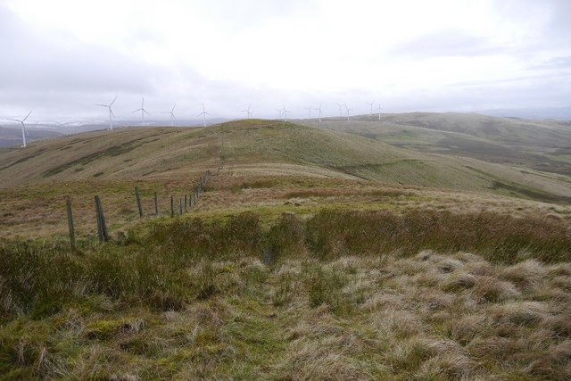
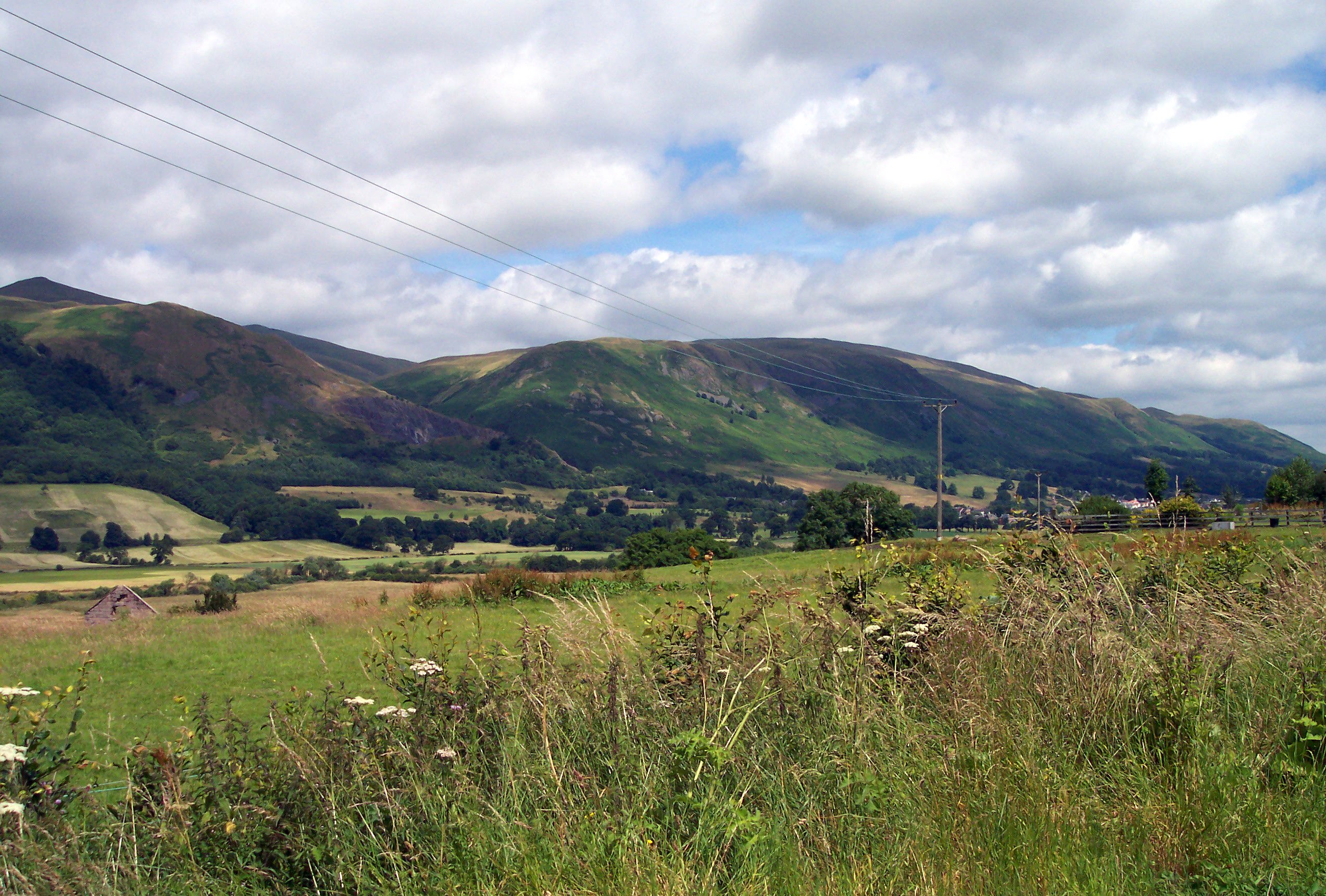
Ben Thrush is a prominent hill located in Perthshire, Scotland. Standing at a height of 1,051 feet (320 meters), it offers stunning panoramic views of the surrounding countryside and is a popular destination for hikers and outdoor enthusiasts.

The hill is known for its diverse flora and fauna, with heather, bracken, and grasses covering its slopes, providing a habitat for a variety of bird species, including red grouse and golden eagles. The hill is also home to a population of red deer, which can often be spotted grazing on its slopes.

Ben Thrush is easily accessible from the nearby town of Crieff, with a well-marked trail leading to the summit. The hike to the top is moderate in difficulty, making it suitable for hikers of all skill levels. Once at the summit, visitors are rewarded with breathtaking views of the surrounding countryside, including the nearby Loch Earn and the distant peaks of the Scottish Highlands.

Overall, Ben Thrush is a must-visit destination for those looking to experience the natural beauty of Perthshire and enjoy a peaceful hike in the Scottish countryside.

If you have any feedback on the listing, please let us know in the comments section below.

Ben Thrush Images

Images are sourced within 2km of 56.234149/-3.6362394 or Grid Reference NN9805. Thanks to Geograph Open Source API. All images are credited.

Green Law Sim's Hill - Green Law ridge with the Green Knowes (Steel Rig) wind farm in the background.
Green Law
Sim's Hill - Green Law ridge with the Green Knowes (Steel Rig) wind farm in the background.
Black Creich Hill A very much conifer clad Ochils hill.
Black Creich Hill
A very much conifer clad Ochils hill.
Borland Glen Passing the wreckage of an abandoned 4*4, the view down the Borland Glen towards Glen Devon. Green Knowes wind farm on the right.
Borland Glen
Passing the wreckage of an abandoned 4*4, the view down the Borland Glen towards Glen Devon. Green Knowes wind farm on the right.
Abandoned vehicle, Sim's Hill Dumping small 4*4s seems to be all the rage on these hills.
Abandoned vehicle, Sim's Hill
Dumping small 4*4s seems to be all the rage on these hills.
Stone circle, Borland Glen Not many stones visible at the site.
Stone circle, Borland Glen
Not many stones visible at the site.
Stone circle, Borland Glen I could only fine two stones.
Stone circle, Borland Glen
I could only fine two stones.
Wetland, Creich Burn Head of Borland Glen.
Wetland, Creich Burn
Head of Borland Glen.
Road, Fanny Hill Runs along the edge of the forest.
Road, Fanny Hill
Runs along the edge of the forest.
Logging road, Black Creich Hill The road runs close to the edge of the plantation.
Logging road, Black Creich Hill
The road runs close to the edge of the plantation.
Road quarry, Black Creich Hill A deep cutting, used as a source of road stone.  There has been a lot of windthrow on this exposed western side of the hill.
Road quarry, Black Creich Hill
A deep cutting, used as a source of road stone. There has been a lot of windthrow on this exposed western side of the hill.
White Creich Hill The Creichs are currently rather aptly named - dun grasses here out in the light while Black Creich is clothed in dense conifers and is a very dark place.
White Creich Hill
The Creichs are currently rather aptly named - dun grasses here out in the light while Black Creich is clothed in dense conifers and is a very dark place.
Lodgepole pines, Black Creich Hill A jumble of branches on the way up the hill. Quite a struggle to make progress and make it in a useful or correct direction.
Lodgepole pines, Black Creich Hill
A jumble of branches on the way up the hill. Quite a struggle to make progress and make it in a useful or correct direction.
Black Creich Hill The summit is around here somewhere.  Something rather Carboniferous about this hill.
Black Creich Hill
The summit is around here somewhere. Something rather Carboniferous about this hill.
Thinning, Burnt Hill Trees have recently been taken out from here with big tracks left behind by tractors along the extraction lanes.
Thinning, Burnt Hill
Trees have recently been taken out from here with big tracks left behind by tractors along the extraction lanes.
Logging road Between Black Creich Hill and Burnt Hill.
Logging road
Between Black Creich Hill and Burnt Hill.
Extraction lane Thinning on Burnt Hill.
Extraction lane
Thinning on Burnt Hill.
Root plate on Burnt Hill Windthrow in a dark Ochil plantation.
Root plate on Burnt Hill
Windthrow in a dark Ochil plantation.
Summit area, Burnt Hill Big ruts from forestry equipment. The area was thinned a few weeks earlier.
Summit area, Burnt Hill
Big ruts from forestry equipment. The area was thinned a few weeks earlier.
Show me another place!

Ben Thrush is located at Grid Ref: NN9805 (Lat: 56.234149, Lng: -3.6362394)

Unitary Authority: Perth and Kinross

Police Authority: Tayside

What 3 Words

///clipboard.acute.smarting. Near Auchterarder, Perth & Kinross

Nearby Locations

Ben Thrush

Related Wikis

Glendevon Castle

Glendevon Castle is a collection of conjoined structures dating from the 15th century. The property is now (2022) semi-derelict. It lies on a private road...

A823 road

The A823 is a road in Scotland which goes from south of Crieff to Dunfermline. It joins onto the A823(M) and the A822 which runs to Crieff.

Strathdevon

Strathdevon is the strath of the River Devon in Clackmannanshire, Scotland. Strathdevon is associated with the parish of Muckhart and was up until 1971...

Ochil Hills

The Ochil Hills ( ; Scottish Gaelic: Monadh Ochail is a range of hills in Scotland north of the Forth valley bordered by the cities of Stirling, Perth...

Nearby Amenities

Located within 500m of 56.234149,-3.6362394
Ben Trush
Ele: 456
Natural: peak
Source: NPE
Lat/Long: 56.2344327/-3.6363824
Generator Method: wind_turbine
Generator Output Electricity: 1.5 MW
Generator Source: wind
Generator Type: horizontal_axis
Power: generator
Lat/Long: 56.2371075/-3.6345352
The data included in this document is from www.openstreetmap.org. The data is made available under ODbL.

Have you been to Ben Thrush?

Leave your review of Ben Thrush below (or comments, questions and feedback).