Carreg y Bîg

Hill, Mountain in Merionethshire

Wales

Carreg y Bîg

Along the fence to Carreg y Bîg The fence marks the rough line of the boundary between the historic Welsh counties of Meirionethshire and Montgomeryshire, which essentially ceased to exist when they merged into the newly created Gwynedd and Powys counties respectively under the 1972 Local Government Act.
Along the fence to Carreg y Bîg Credit: Richard Law

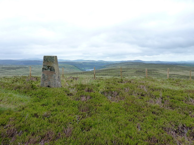
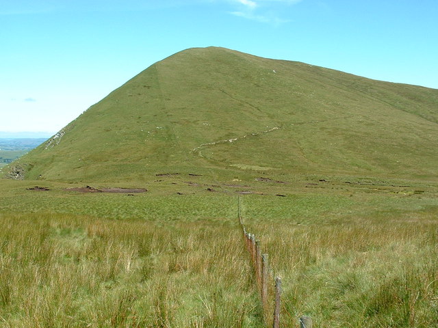
Carreg y Bîg is a prominent hill located in Merionethshire, Wales. It is situated near the small village of Beddgelert in the Snowdonia National Park and forms part of the scenic Moel Hebog range. Standing at an elevation of approximately 603 meters (1,978 feet), it offers breathtaking panoramic views of the surrounding landscape.

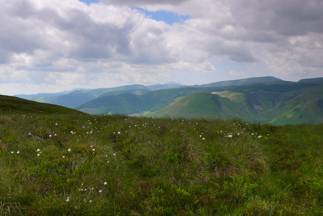
The hill is predominantly composed of rugged, rocky terrain, with steep slopes and craggy outcrops. It is a popular destination for hikers and outdoor enthusiasts, who are drawn to its challenging yet rewarding ascent. The path to the summit is well-marked, but requires a moderate level of fitness and proper hiking equipment.

From the top of Carreg y Bîg, visitors are treated to stunning vistas of the Snowdonia National Park and its majestic peaks, including the iconic Mount Snowdon. On clear days, it is possible to see as far as the Llŷn Peninsula and the Irish Sea. The hill also offers glimpses of the picturesque village of Beddgelert nestled amidst verdant valleys and flowing rivers.

Carreg y Bîg is rich in natural beauty and biodiversity, with an array of plant and animal species inhabiting its slopes. It is home to a variety of birds, including the elusive peregrine falcon and the red kite. The hill also boasts an abundance of wildflowers, such as heather and bilberry, which paint the landscape with vibrant colors during the summer months.

Overall, Carreg y Bîg is a captivating destination for those seeking an adventurous hike amidst stunning Welsh scenery. Its challenging ascent and rewarding views make it a must-visit for outdoor enthusiasts and nature lovers alike.

If you have any feedback on the listing, please let us know in the comments section below.

Carreg y Bîg Images

Images are sourced within 2km of 52.768018/-3.591736 or Grid Reference SH9220. Thanks to Geograph Open Source API. All images are credited.

Along the fence to Carreg y Bîg The fence marks the rough line of the boundary between the historic Welsh counties of Meirionethshire and Montgomeryshire, which essentially ceased to exist when they merged into the newly created Gwynedd and Powys counties respectively under the 1972 Local Government Act.
Along the fence to Carreg y Bîg
The fence marks the rough line of the boundary between the historic Welsh counties of Meirionethshire and Montgomeryshire, which essentially ceased to exist when they merged into the newly created Gwynedd and Powys counties respectively under the 1972 Local Government Act.
Moel Llygoed summit Recorded as 598m (1962ft), this is an western outlier of Mynydd Coch.
Moel Llygoed summit
Recorded as 598m (1962ft), this is an western outlier of Mynydd Coch.
Fenceline down to Mynydd Coch A relatively new fence (my evidence being several pieces of the wrappers from the wire which were lying in the heather) leading from Carreg y Bîg off to the main eastern summit of Mynydd Coch.
Fenceline down to Mynydd Coch
A relatively new fence (my evidence being several pieces of the wrappers from the wire which were lying in the heather) leading from Carreg y Bîg off to the main eastern summit of Mynydd Coch.
Fenceline below Mynydd Coch A new fence running across the moor between Carreg y Bîg and Mynydd Coch.
Fenceline below Mynydd Coch
A new fence running across the moor between Carreg y Bîg and Mynydd Coch.
Substantial corner-bracing On the new fence across the moor, no-one's taking any chances with the bracing at this corner.
Substantial corner-bracing
On the new fence across the moor, no-one's taking any chances with the bracing at this corner.
Approaching Mynydd Coch from the SW A little way below the summit trig, this new fence runs across the watershed between the Hirddu and Twrch valleys.
Approaching Mynydd Coch from the SW
A little way below the summit trig, this new fence runs across the watershed between the Hirddu and Twrch valleys.
Mynydd Coch flush bracket Flush Bracket 10331 embedded into the trig on the summit; originally levelled when it was constructed in June 1959 at 539.366m above Ordnance Datum Newlyn.
Mynydd Coch flush bracket
Flush Bracket 10331 embedded into the trig on the summit; originally levelled when it was constructed in June 1959 at 539.366m above Ordnance Datum Newlyn.
Mynydd Coch trig A fine viewpoint, here looking over to a glimpse of Lake Vyrnwy. The entire area probably sees no more than handful of walkers in a year (the trig has only been logged 12 times in 19 years on <span class="nowrap"><a title="http://www.trigpointing.uk/)" rel="nofollow ugc noopener" href="http://www.trigpointing.uk/)">Link</a><img style="margin-left:2px;" alt="External link" title="External link - shift click to open in new window" src="https://s1.geograph.org.uk/img/external.png" width="10" height="10"/></span> which is probably a reflection of the difficulty of access; it's unrelenting deep heather and tussock grass for miles in every direction.
Mynydd Coch trig
A fine viewpoint, here looking over to a glimpse of Lake Vyrnwy. The entire area probably sees no more than handful of walkers in a year (the trig has only been logged 12 times in 19 years on LinkExternal link which is probably a reflection of the difficulty of access; it's unrelenting deep heather and tussock grass for miles in every direction.
North of Blaen Cownwy Endless moorland between the Hirddu and Cownwy valleys.
North of Blaen Cownwy
Endless moorland between the Hirddu and Cownwy valleys.
East of Mynydd Coch This is not country to be taken lightly. Every mile walked has to be fought for; the heather is a lot deeper than the pictures suggest.
East of Mynydd Coch
This is not country to be taken lightly. Every mile walked has to be fought for; the heather is a lot deeper than the pictures suggest.
Towards Blaen Cownwy Looking down the SE hillside of Mynydd Coch towards the valley of the Afon Cownwy.
Towards Blaen Cownwy
Looking down the SE hillside of Mynydd Coch towards the valley of the Afon Cownwy.
Marker cairn above Blaen Cownwy Unmarked on the maps, and not noted by any of the historic artefact surveys (Coflein etc), this marker cairn is one of a number spread around these hills. It overlooks the upper Afon Hirddu Fach.
Marker cairn above Blaen Cownwy
Unmarked on the maps, and not noted by any of the historic artefact surveys (Coflein etc), this marker cairn is one of a number spread around these hills. It overlooks the upper Afon Hirddu Fach.
The Blaen Cownwy cairn Perched on a small rocky eminence (there's a bit of an outcrop in the dead ground just 10 yards away) this marker cairn has an historic aura of semi-permanence. It also makes a good place to sit for lunch.
The Blaen Cownwy cairn
Perched on a small rocky eminence (there's a bit of an outcrop in the dead ground just 10 yards away) this marker cairn has an historic aura of semi-permanence. It also makes a good place to sit for lunch.
The Blaen Cownwy cairn Overlooking the upper Hirddu Fach valley
The Blaen Cownwy cairn
Overlooking the upper Hirddu Fach valley
Cwm Llygoed Golygfa lawr Cwm Llygoed tuag at Llanymawddwy / A  view down Cwm Llygoed towards Llanymawddwy.
Cwm Llygoed
Golygfa lawr Cwm Llygoed tuag at Llanymawddwy / A view down Cwm Llygoed towards Llanymawddwy.
Uwchben Cwm Llygoed / Above Cwm Llygoed Plu'r Gweunydd / Cotton Grass.
Uwchben Cwm Llygoed / Above Cwm Llygoed
Plu'r Gweunydd / Cotton Grass.
Carnedd fawr / Large cairn Carnedd ar gopa di-enw / Cairn on a nameless summit.
Carnedd fawr / Large cairn
Carnedd ar gopa di-enw / Cairn on a nameless summit.
Sgarp bach / Small scarp Sgarp bach yng nghanol y grug a molinia/ Small scarp in the middle of the heather and molinia.
Sgarp bach / Small scarp
Sgarp bach yng nghanol y grug a molinia/ Small scarp in the middle of the heather and molinia.
Show me another place!

Carreg y Bîg is located at Grid Ref: SH9220 (Lat: 52.768018, Lng: -3.591736)

Unitary Authority: Gwynedd

Police Authority: North Wales

What 3 Words

///smallest.hypocrite.october. Near Llanuwchllyn, Gwynedd

Nearby Locations

Carreg y Bîg

Related Wikis

Llanymawddwy

Llanymawddwy () is a village in the community of Mawddwy in south-east Gwynedd, Wales, which is to the north of the larger village of Dinas Mawddwy, on...

Bwlch y Groes

Bwlch y Groes (translates from Welsh as pass of the cross) is the second highest public road mountain pass in Wales, with a summit altitude of 545 metres...

Esgeiriau Gwynion

Esgeiriau Gwynion (Welsh for "white shanks") is a mountain in north Wales. It is the smallest of the three Marilyns that form the Aran range, the others...

Rhiwargor

Rhiwargor is a hamlet in Powys, Wales. It is located north of Lake Vyrnwy. The hamlet is made up of a few houses with no amenities. It does however, lie...

Nearby Amenities

Located within 500m of 52.768018,-3.591736
Carreg y Big
Ele: 589
Natural: peak
Lat/Long: 52.7680621/-3.5915049
The data included in this document is from www.openstreetmap.org. The data is made available under ODbL.

Have you been to Carreg y Bîg?

Leave your review of Carreg y Bîg below (or comments, questions and feedback).