Beinn na Carra

Hill, Mountain in Perthshire

Scotland

Beinn na Carra

Cablea junction Where A826 on right leaves A822.
Cablea junction Credit: Stanley Howe

Beinn na Carra is a prominent hill located in Perthshire, Scotland. It stands at an impressive height of 761 meters (2,497 feet) and offers stunning views of the surrounding countryside. The hill is popular among hikers and outdoor enthusiasts for its challenging terrain and rewarding vistas.

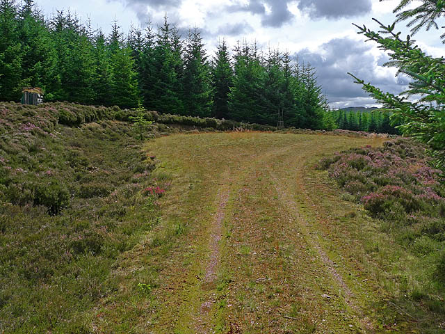
Beinn na Carra is part of the Grampian Mountains, a range known for its rugged beauty and diverse wildlife. The hill is covered in heather and grasses, creating a picturesque landscape that changes with the seasons. On a clear day, visitors can see for miles around, spotting other mountains, lochs, and forests in the distance.

The hill is accessible via a number of different walking routes, ranging from easy to moderate in difficulty. The most popular route starts from the nearby village of Amulree and takes hikers through a mixture of woodland and open moorland before reaching the summit. From there, the panoramic views make the effort worthwhile.

Overall, Beinn na Carra is a must-visit destination for those looking to experience the natural beauty of Perthshire and challenge themselves with a rewarding hike.

If you have any feedback on the listing, please let us know in the comments section below.

Beinn na Carra Images

Images are sourced within 2km of 56.541484/-3.7507208 or Grid Reference NN9240. Thanks to Geograph Open Source API. All images are credited.

Cablea junction Where A826 on right leaves A822.
Cablea junction
Where A826 on right leaves A822.
Deanshaugh By Old Military Road (A822).
Deanshaugh
By Old Military Road (A822).
Heading north on the old military road through Glen Cochill Road, scrub, forest...and windmills.
Heading north on the old military road through Glen Cochill
Road, scrub, forest...and windmills.
Road heading north
Road heading north
On the A822 road to Amulree Meall nam Fuaran is in the centre-distance.
On the A822 road to Amulree
Meall nam Fuaran is in the centre-distance.
Old Milestone by the A822, Cablea, Logierait Parish By the A822, in parish of Logierait (District), Cablea, South of junction with A826, by wall on verge, East side of road.

Inscription once read:- : (Amulree / 2) : : (Aberfeldy / 9) :

Surveyed

Milestone Society National ID: PK_AFCF09
Old Milestone by the A822, Cablea, Logierait Parish
By the A822, in parish of Logierait (District), Cablea, South of junction with A826, by wall on verge, East side of road. Inscription once read:- : (Amulree / 2) : : (Aberfeldy / 9) : Surveyed Milestone Society National ID: PK_AFCF09
Old Milestone by the A822, Ballachraggan, Little Dunkeld parish Stone post by the A822, in parish of Little Dunkeld (District), Ballachraggan, between electricity pylons 226 and 227, South side of road.

Inscription once read:-
: (Amulree / 2¾) : : (Dunkeld / 7) : 

Surveyed

Milestone Society National ID: PK_DKAM07
Old Milestone by the A822, Ballachraggan, Little Dunkeld parish
Stone post by the A822, in parish of Little Dunkeld (District), Ballachraggan, between electricity pylons 226 and 227, South side of road. Inscription once read:- : (Amulree / 2¾) : : (Dunkeld / 7) : Surveyed Milestone Society National ID: PK_DKAM07
Above Deanhaugh
Above Deanhaugh
A822 north of Amulree
Heathland and forestry in Glen Cochill
Cochill Burn Looking S from position
Cochill Burn
Looking S from position
Sheep fank in Glen Cochill With sheep!
Sheep fank in Glen Cochill
With sheep!
Open Moorland Cochill Forest in the distance.
Open Moorland
Cochill Forest in the distance.
Wester Ballachraggan In Strathbraan.
Wester Ballachraggan
In Strathbraan.
The southern end of Griffin Forest The forestry track does not continue as far as is shown on the OS 1:50,000 map - only a rough deer path continues through the trees. Dalreoch Hill is visible in the distance on the south side of Strath Braan.
The southern end of Griffin Forest
The forestry track does not continue as far as is shown on the OS 1:50,000 map - only a rough deer path continues through the trees. Dalreoch Hill is visible in the distance on the south side of Strath Braan.
Forest Track in Griffin Forest A widened area near the end of the track.
Forest Track in Griffin Forest
A widened area near the end of the track.
Forest Track in Griffin Forest
Meall Mòr Moorland hill, well on the Strath Braan side. The northern approaches are clothed in Sitka spruce and the more amenable southern approaches are guarded by a lack of car parking and a very hazardous road to walk along. One for the bike.

--
2014
Several laybys have appeared on the road through Strath Braan. They were built for the traffic constructing the wind farms.  Afterwards they were all sealed off at great expense, lest anyone dare stop.  It's a Perthshire thing.
There is still a good spot at the A826/A822 junction.
Meall Mòr
Moorland hill, well on the Strath Braan side. The northern approaches are clothed in Sitka spruce and the more amenable southern approaches are guarded by a lack of car parking and a very hazardous road to walk along. One for the bike. -- 2014 Several laybys have appeared on the road through Strath Braan. They were built for the traffic constructing the wind farms. Afterwards they were all sealed off at great expense, lest anyone dare stop. It's a Perthshire thing. There is still a good spot at the A826/A822 junction.
Show me another place!

Beinn na Carra is located at Grid Ref: NN9240 (Lat: 56.541484, Lng: -3.7507208)

Unitary Authority: Perth and Kinross

Police Authority: Tayside

What 3 Words

///ladder.frocks.perch. Near Aberfeldy, Perth & Kinross

Related Wikis

Amulree

Amulree (Scottish Gaelic: Àth Maol Ruibhe, 'Ford of [St.] Maelrubha') is a small hamlet in Perth and Kinross, Scotland. It lies in hilly country on the...

Loch Fender

Loch Fender is a small irregular shaped freshwater loch that lies to the north of Loch Freuchie and three miles south-south-east of Amulree and 2+1⁄2 miles...

Loch Kennard

Loch Kennard is freshwater loch located south-east of Aberfeldy, situated on Grandtully Hill in Perth and Kinross within Griffin Forest in Scotland....

Achnafauld

Achnafauld (, Scottish Gaelic: Achadh na Follt) is a settlement in the Scottish Highlands, about 15 miles (24 km) northwest of Perth. It is located in...

Have you been to Beinn na Carra?

Leave your review of Beinn na Carra below (or comments, questions and feedback).