Cefn Coch

Hill, Mountain in Merionethshire

Wales

Cefn Coch

Trig Point on Foel y Geifr
Trig Point on Foel y Geifr Credit: Colin Park

The requested URL returned error: 429 Too Many Requests

If you have any feedback on the listing, please let us know in the comments section below.

Cefn Coch Images

Images are sourced within 2km of 52.826657/-3.5995192 or Grid Reference SH9226. Thanks to Geograph Open Source API. All images are credited.
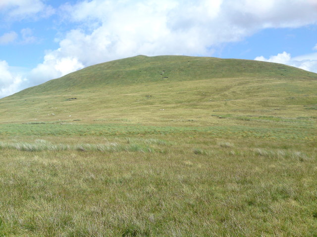
Trig Point on Foel y Geifr
Bend near Pen y Cefn
Lane north of cattle grid
Road junction at Ty Nant
Cattle grid in Cwm Cynllwyd
Trig point on Foel y Geifr 2054' / 626m The Aran ridge is on the horizon.
Trig point on Foel y Geifr 2054' / 626m
The Aran ridge is on the horizon.
Foel Figenau from western slopes Foel Figenau is a gorgeous little hill which peeks temptingly above the Penllyn forest.  I can see it from my house 20 miles away.  It's quite a slog to get to however. As well as the obvious reward of bagging a splendid summit, there are also the endless bilberries which grow in profusion near the forest track below - and which we (ahem, my wife) makes into what we call Figenau Pie.  Hot, and with ice cream - to die for.
Foel Figenau from western slopes
Foel Figenau is a gorgeous little hill which peeks temptingly above the Penllyn forest. I can see it from my house 20 miles away. It's quite a slog to get to however. As well as the obvious reward of bagging a splendid summit, there are also the endless bilberries which grow in profusion near the forest track below - and which we (ahem, my wife) makes into what we call Figenau Pie. Hot, and with ice cream - to die for.
View south along Cwm Cynllwyd
Narrow lane ascending Cwm Cynllwyd
Narrow lane descending Cwm Cynllwyd
Upper eastern slope of Foel y Geifr Foel y Geifr is the highest of three 600m peaks on the west side of upper Cwm Hirnant. The slope seen here is descending eastwards towards the valley road which it reaches close to the col at the cwm head.
Upper eastern slope of Foel y Geifr
Foel y Geifr is the highest of three 600m peaks on the west side of upper Cwm Hirnant. The slope seen here is descending eastwards towards the valley road which it reaches close to the col at the cwm head.
Cwm Cynllwyd Climbing up the road on our way to Lake Vyrnwy. Arenig Fawr can be seen in the distance.
Cwm Cynllwyd
Climbing up the road on our way to Lake Vyrnwy. Arenig Fawr can be seen in the distance.
Coed Tyn y Fedw The western side of the forest has been cleared and replanted. This pool has formed in a small hollow near the forest road.
Coed Tyn y Fedw
The western side of the forest has been cleared and replanted. This pool has formed in a small hollow near the forest road.
Coed Tyn y Fedw The forestry road through Coed Tyn y Fedw in Cwm Cynllwyd.
Coed Tyn y Fedw
The forestry road through Coed Tyn y Fedw in Cwm Cynllwyd.
Coed Tyn y Fedw In Cwm Cynllwyd. This section of the forest has been felled and replanted. In the distance is Moel y Geifr.
Coed Tyn y Fedw
In Cwm Cynllwyd. This section of the forest has been felled and replanted. In the distance is Moel y Geifr.
Moorlands Moorland on the western slopes of Cefn Coch, in Cwm Cynllwyd. It would have been very soggy walking had the weather not been so dry.
Moorlands
Moorland on the western slopes of Cefn Coch, in Cwm Cynllwyd. It would have been very soggy walking had the weather not been so dry.
Cefn Coch Southerly facing flanks of Cefn Coch.
Cefn Coch
Southerly facing flanks of Cefn Coch.
Pines on the hillside A stand of pines, possibly planted as a shelterbelt, alongside the track leading down from Cefn Coch to Ty Nant.
Pines on the hillside
A stand of pines, possibly planted as a shelterbelt, alongside the track leading down from Cefn Coch to Ty Nant.
Show me another place!

Cefn Coch is located at Grid Ref: SH9226 (Lat: 52.826657, Lng: -3.5995192)

Unitary Authority: Gwynedd

Police Authority: North Wales

What 3 Words

///launch.ecologist.foster. Near Llanuwchllyn, Gwynedd

Nearby Locations

Cefn Coch

Related Wikis

Foel y Geifr

Foel y Geifr is a subsidiary summit of Esgeiriau Gwynion, and included in a group of hills known as the Hirnantau. These hills rise from the south east...

Meirionnydd Nant Conwy (UK Parliament constituency)

Meirionnydd Nant Conwy was a constituency represented in the House of Commons of the Parliament of the United Kingdom. It elected one Member of Parliament...

Foel Goch (Hirnant)

Foel Goch is a subsidiary summit of Esgeiriau Gwynion, and is included in a group of hills known as the Hirnantau. These hills rise from the south east...

Bwlch y Groes

Bwlch y Groes (translates from Welsh as pass of the cross) is the second highest public road mountain pass in Wales, with a summit altitude of 545 metres...

Nearby Amenities

Located within 500m of 52.826657,-3.5995192
Cefn Coch
Ele: 594
Natural: peak
Wikidata: Q13126966
Wikipedia: cy:Cefn Coch
Lat/Long: 52.8267284/-3.5996417
The data included in this document is from www.openstreetmap.org. The data is made available under ODbL.

Have you been to Cefn Coch?

Leave your review of Cefn Coch below (or comments, questions and feedback).