Bràigh Sròn Ghorm

Hill, Mountain in Perthshire

Scotland

Bràigh Sròn Ghorm

Very small shelter on NW slopes of Aonach na Cloiche Mòire About the right size to fit a solitary sheep, but I don't think that is the purpose of this wee shelter.  Possibly a grouse butt?  But no others in sight nearby, and still too small to duck behind and surprise a startled bird.
Very small shelter on NW slopes of Aonach na Cloiche Mòire Credit: Gary Dickson

Bràigh Sròn Ghorm, also known as Meall nan Eun, is a prominent hill located in the county of Perthshire, Scotland. Standing at an elevation of 1,064 meters (3,491 feet), it is classified as a Corbett, which is a Scottish mountain between 2,500 and 3,000 feet in height.

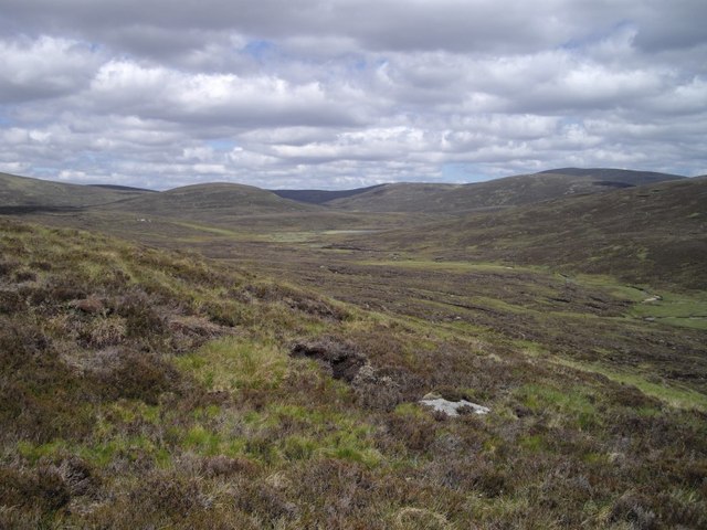
Situated in the southern part of the Cairngorms National Park, Bràigh Sròn Ghorm offers breathtaking views of the surrounding highlands and the picturesque Loch Tummel to the southwest. Its distinctive shape, resembling the shape of a beak, makes it easily recognizable from a distance.

The hill is primarily composed of granite and features a range of rugged terrain, including steep slopes and rocky outcrops. It is a popular destination for hikers and mountaineers, offering various routes to the summit. One of the most commonly used routes starts from the picturesque village of Tummel Bridge, leading walkers through heather moorland and birch woods before ascending the hill.

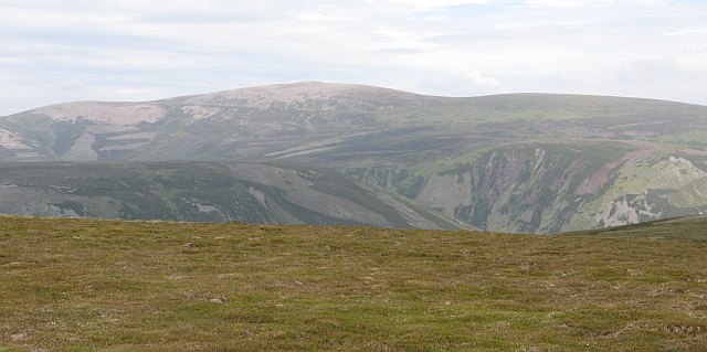
The summit of Bràigh Sròn Ghorm provides panoramic views, showcasing the vast expanse of the Cairngorms National Park, including nearby peaks such as Schiehallion and Ben Lawers. On a clear day, it is even possible to see as far as the Ben Nevis range to the west.

Due to its relatively accessible location and stunning vistas, Bràigh Sròn Ghorm attracts outdoor enthusiasts throughout the year, offering a challenging yet rewarding experience for those seeking to explore the natural beauty of Perthshire's mountains.

If you have any feedback on the listing, please let us know in the comments section below.

Bràigh Sròn Ghorm Images

Images are sourced within 2km of 56.883441/-3.8017078 or Grid Reference NN9078. Thanks to Geograph Open Source API. All images are credited.

Very small shelter on NW slopes of Aonach na Cloiche Mòire About the right size to fit a solitary sheep, but I don't think that is the purpose of this wee shelter.  Possibly a grouse butt?  But no others in sight nearby, and still too small to duck behind and surprise a startled bird.
Very small shelter on NW slopes of Aonach na Cloiche Mòire
About the right size to fit a solitary sheep, but I don't think that is the purpose of this wee shelter. Possibly a grouse butt? But no others in sight nearby, and still too small to duck behind and surprise a startled bird.
Tarf Water Looking up Tarf Water as it skirts the northern flank of Braigh Sron Ghorm
Tarf Water
Looking up Tarf Water as it skirts the northern flank of Braigh Sron Ghorm
On the slopes of Carn a' Chiaraidh Looking towards the valley of the Fèith an Lochain.  This is rough countryside.
On the slopes of Carn a' Chiaraidh
Looking towards the valley of the Fèith an Lochain. This is rough countryside.
Fèith an Lochain A tributary joins the Fèith an Lochain from the west.
Fèith an Lochain
A tributary joins the Fèith an Lochain from the west.
Snow covered moorland east of Braigh Sron Ghorm
Snow covered moorland east of Sron Dubh Looking towards the remote Corbett of Beinn Bhreac
Snow covered moorland east of Sron Dubh
Looking towards the remote Corbett of Beinn Bhreac
Allt nan Creagan Breac The top of the Allt nan Creagan Breac which drains part of the Carn a' Chlamhain massif into Gleann Mhairc and eventually the Tilt. The wild peatlands of the Tarf  can be seen through the gap.
Allt nan Creagan Breac
The top of the Allt nan Creagan Breac which drains part of the Carn a' Chlamhain massif into Gleann Mhairc and eventually the Tilt. The wild peatlands of the Tarf can be seen through the gap.
Bog on Carn a' Chlamhain Just east of the north (granite) top of Carn a' Chlamhain, a boggy patch on the broad ridge running towards Aonach na Cloiche Mòire.
Bog on Carn a' Chlamhain
Just east of the north (granite) top of Carn a' Chlamhain, a boggy patch on the broad ridge running towards Aonach na Cloiche Mòire.
West side of Aonach na Cloiche Mòire View down the hill towards Gleann Mhairc. Beinn Dearg on the skyline with the Carn a' Chiaraidh end of Beinn Mheadhoineach across the glen.
West side of Aonach na Cloiche Mòire
View down the hill towards Gleann Mhairc. Beinn Dearg on the skyline with the Carn a' Chiaraidh end of Beinn Mheadhoineach across the glen.
Granite boulders on Aonach na Cloiche Mòire An area of frost shattered granite to the north of Aonach na Cloiche Mòire. View through Gleann Mhairc, past the loch and huge bogs of Tarf to Beinn Bhreac, which is waiting for a resurvey - now if that hill ever became a munro!
Granite boulders on Aonach na Cloiche Mòire
An area of frost shattered granite to the north of Aonach na Cloiche Mòire. View through Gleann Mhairc, past the loch and huge bogs of Tarf to Beinn Bhreac, which is waiting for a resurvey - now if that hill ever became a munro!
North of Chlamhain Gentle bogs in a landscape which was surprisingly easy to cross. A hare probably escaping a fox (it was running towards me at first) crossing the wide ridge between Aonach na Cloiche Mòire and Bràigh Sròn Ghorm.
I took a lot of pictures out here, but few came out due to the strong winds causing a lot of camera shake.
North of Chlamhain
Gentle bogs in a landscape which was surprisingly easy to cross. A hare probably escaping a fox (it was running towards me at first) crossing the wide ridge between Aonach na Cloiche Mòire and Bràigh Sròn Ghorm. I took a lot of pictures out here, but few came out due to the strong winds causing a lot of camera shake.
Below Bràigh Sròn Ghorm A wonderfully isolated place to the north of Carn a' Chlamhain and above the Tarf. Lovely light but a tough wind, which somewhat curtailed my activities today.
The track shown on the latest maps over Carn a' Chlamhain is only a bulldozed track as far as NN923751, from there it is more like a path and continues to just past this col.
Below Bràigh Sròn Ghorm
A wonderfully isolated place to the north of Carn a' Chlamhain and above the Tarf. Lovely light but a tough wind, which somewhat curtailed my activities today. The track shown on the latest maps over Carn a' Chlamhain is only a bulldozed track as far as NN923751, from there it is more like a path and continues to just past this col.
Tundra, Bràigh Sròn Ghorm Near the summit of Bràigh Sròn Ghorm with a view over moss and hardy plants to the Tarf.
Tundra, Bràigh Sròn Ghorm
Near the summit of Bràigh Sròn Ghorm with a view over moss and hardy plants to the Tarf.
Bràigh Sròn Ghorm The day's destination, a summit cairn far from just about anywhere. A great place to get to, now it is time to turn into the howling wind and head for home. From now on, each step need only be taken once. 
Carn an Fhidleir,  the meeting place of Perthshire, Aberdeenshire and Aberdeenshire and about as far as you can get from a public driving road in Great Britain, is lit up in the background.
Bràigh Sròn Ghorm
The day's destination, a summit cairn far from just about anywhere. A great place to get to, now it is time to turn into the howling wind and head for home. From now on, each step need only be taken once. Carn an Fhidleir, the meeting place of Perthshire, Aberdeenshire and Aberdeenshire and about as far as you can get from a public driving road in Great Britain, is lit up in the background.
Cùil Riabhach A grassy corrie on the northern side of Carn a' Chlamhain.
Cùil Riabhach
A grassy corrie on the northern side of Carn a' Chlamhain.
Cùil Riabhach A grassy corrie to the north of Carn a' Chlamhain. The ground gets more peaty as height is lost. Drains into the Tarf.
Cùil Riabhach
A grassy corrie to the north of Carn a' Chlamhain. The ground gets more peaty as height is lost. Drains into the Tarf.
Cùil Riabhach Cùil Riabhach is a grassy corrie north of Carn a' Chlamhain and Aonach na Cloiche Mòire. View of the upper "headwall". Very easy walking here.
Cùil Riabhach
Cùil Riabhach is a grassy corrie north of Carn a' Chlamhain and Aonach na Cloiche Mòire. View of the upper "headwall". Very easy walking here.
Tarf Water Looking up Tarf Water, with the dark flank of Sron Garbh ahead.
Tarf Water
Looking up Tarf Water, with the dark flank of Sron Garbh ahead.
Show me another place!

Bràigh Sròn Ghorm is located at Grid Ref: NN9078 (Lat: 56.883441, Lng: -3.8017078)

Unitary Authority: Perth and Kinross

Police Authority: Tayside

What 3 Words

///prove.added.headliner. Near Blair Atholl, Perth & Kinross

Nearby Locations

Bràigh Sròn Ghorm

Related Wikis

Carn a' Chlamain

Càrn a' Chlamain (Gaelic: Càrn a' Chlamhain) is a Scottish mountain situated roughly 12 kilometres north of Blair Atholl in the Forest of Atholl. It is...

Beinn Dearg (Blair Atholl)

Beinn Dearg (1,009 m) is a mountain in the Grampian Mountains of Scotland. It lies north of the Perth and Kinross village of Blair Atholl, in the Forest...

Glen Tilt

Glen Tilt (Scottish Gaelic: Gleann Teilt) is a glen in the extreme north of Perthshire, Scotland. Beginning at the confines of Aberdeenshire, it follows...

Carn an Fhidhleir

Carn an Fhidhleir (994 m) is a mountain in the Grampian Mountains of Scotland. It lies on the border of Inverness-shire, Perthshire and Aberdeenshire,...

Nearby Amenities

Located within 500m of 56.883441,-3.8017078
Braigh Sron Ghorm
Ele: 878
Natural: peak
Lat/Long: 56.8833097/-3.8014382
The data included in this document is from www.openstreetmap.org. The data is made available under ODbL.

Have you been to Bràigh Sròn Ghorm?

Leave your review of Bràigh Sròn Ghorm below (or comments, questions and feedback).