Berry Hill

Hill, Mountain in Perthshire

Scotland

Berry Hill

View from Tillicoultry track As the track starts to climb nearer the Ochils good views open up northwards. Unfortunately today's view was rather hazy due to damp weather.
View from Tillicoultry track Credit: Lis Burke

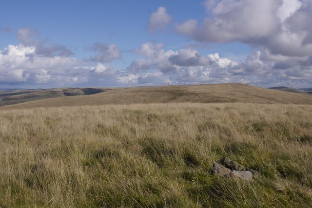
Berry Hill is a prominent hill located in the region of Perthshire, Scotland. Standing at an elevation of 762 feet, it offers stunning panoramic views of the surrounding countryside and is a popular destination for hikers and nature enthusiasts.

The hill is characterized by its rolling green slopes, rocky outcrops, and diverse flora and fauna. It is home to a variety of plant species, including heather, gorse, and wildflowers, as well as a range of bird and animal life such as red deer, foxes, and birds of prey.

Berry Hill is easily accessible by foot, with a network of well-maintained trails leading to the summit. Along the way, hikers can enjoy the peaceful ambiance of the Scottish countryside and may even spot some local wildlife.

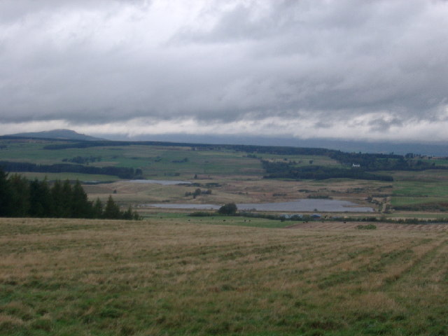
At the top of Berry Hill, visitors are rewarded with breathtaking views of the surrounding landscape, including the picturesque town of Perth and the River Tay. On a clear day, it is possible to see as far as the Grampian Mountains to the north.

Overall, Berry Hill is a beautiful natural landmark that offers a peaceful retreat for outdoor enthusiasts seeking to explore the stunning scenery of Perthshire.

If you have any feedback on the listing, please let us know in the comments section below.

Berry Hill Images

Images are sourced within 2km of 56.228299/-3.793755 or Grid Reference NN8805. Thanks to Geograph Open Source API. All images are credited.

View from Tillicoultry track As the track starts to climb nearer the Ochils good views open up northwards. Unfortunately today's view was rather hazy due to damp weather.
View from Tillicoultry track
As the track starts to climb nearer the Ochils good views open up northwards. Unfortunately today's view was rather hazy due to damp weather.
View from the head of Glen Bee On a good day there must be a great view over Upper Glendevon Reservoir to the hills beyond. This was not such a day!
View from the head of Glen Bee
On a good day there must be a great view over Upper Glendevon Reservoir to the hills beyond. This was not such a day!
Glen of Kinpauch track The start of the track that leads down to Blackford.
Glen of Kinpauch track
The start of the track that leads down to Blackford.
View from Tambeth Hill A view to the north-east from Tambeth Hill, with forestry plantations on Berry Hill visible in the distance. Land use here is predominantly agricultural, with most land used as rough grazing.
View from Tambeth Hill
A view to the north-east from Tambeth Hill, with forestry plantations on Berry Hill visible in the distance. Land use here is predominantly agricultural, with most land used as rough grazing.
North side of Craigentaggert Hill The hillside is covered in heather with the remains of a grouse butt in the foreground.
North side of Craigentaggert Hill
The hillside is covered in heather with the remains of a grouse butt in the foreground.
Moorland, Craigentaggart Hill Deep heather, and little or no grazing.  Not an easy place.
Moorland, Craigentaggart Hill
Deep heather, and little or no grazing. Not an easy place.
An old boundary Remains of a dyke, now overgrown on Craigentaggert Hill.
An old boundary
Remains of a dyke, now overgrown on Craigentaggert Hill.
Craigentaggert Hill The northern moorland slopes of Craigentaggert Hill on the Strathallan side of the Ochil Hills.
Craigentaggert Hill
The northern moorland slopes of Craigentaggert Hill on the Strathallan side of the Ochil Hills.
Craigentaggert Hill A fence on the northern side. Once over the fence on the upper slopes the underfoot conditions improve.
Craigentaggert Hill
A fence on the northern side. Once over the fence on the upper slopes the underfoot conditions improve.
Fence, Craigentaggert Hill
On Craigentaggert Hill View towards Ben Vorlich and Stùc a' Chroin.
On Craigentaggert Hill
View towards Ben Vorlich and Stùc a' Chroin.
Towards Core Hill View from Craigentaggert Hill.
Towards Core Hill
View from Craigentaggert Hill.
Summit, Craigentaggert Hill
Rock exposure, Craigentaggert Hill Rocks on a mostly grassy hill.
Rock exposure, Craigentaggert Hill
Rocks on a mostly grassy hill.
Glen of Kinpauch View into a glen which forms a pass between Blackford and upper Glen Devon.
Glen of Kinpauch
View into a glen which forms a pass between Blackford and upper Glen Devon.
Glen of Kinpauch View off the Ochil Hills towards the Highlands.
Glen of Kinpauch
View off the Ochil Hills towards the Highlands.
Hillock beside fence on Burnfoot Hill
Side of Craigentaggert Hill towards Core Hill
Show me another place!

Berry Hill is located at Grid Ref: NN8805 (Lat: 56.228299, Lng: -3.793755)

Unitary Authority: Perth and Kinross

Police Authority: Tayside

What 3 Words

///homecare.windmills.glad. Near Alva, Clackmannanshire

Nearby Locations

Berry Hill

Related Wikis

Tullibardine distillery

Tullibardine distillery is a Scottish distillery since 1949, producing a single malt whisky. The whisky distillery is located in Blackford, Perth and Kinross...

Blackford, Perth and Kinross

Blackford (Scottish Gaelic: Srath Gaoithe) is located in Perth and Kinross, Scotland, approximately 5 miles (8 kilometres) from the town of Auchterarder...

Blackford railway station

Blackford railway station served the village of Blackford, Perth and Kinross, Scotland from 1848 to 1956 on the Scottish Central Railway. == History... ==

Carsbreck railway station

Carsbreck railway station was a private station opened on the Scottish Central Railway near Carsebreck Loch, the Royal Caledonian Curling pond, between...

Have you been to Berry Hill?

Leave your review of Berry Hill below (or comments, questions and feedback).