Beinn Bhreac

Hill, Mountain in Perthshire

Scotland

Beinn Bhreac

On top of Beinn Bhreac Looking towards the Cairngorms.
On top of Beinn Bhreac Credit: Alan Reid

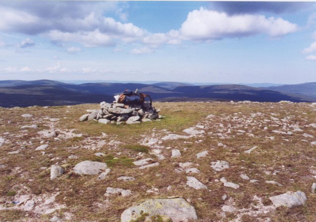
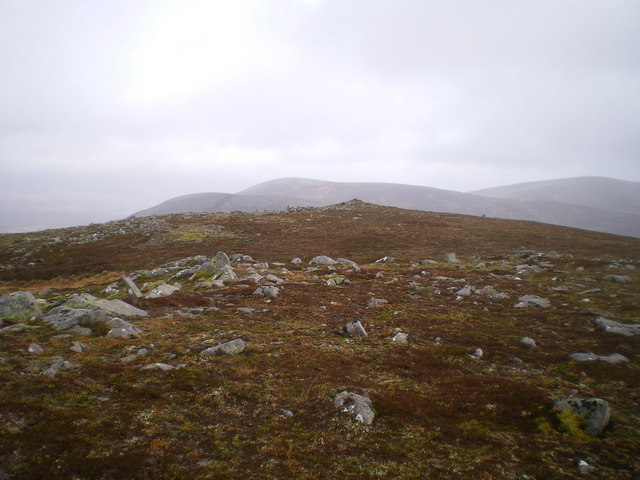
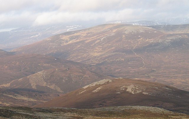
Beinn Bhreac is a prominent hill located in Perthshire, Scotland. It is part of the Grampian Mountains range and stands at an elevation of 931 meters (3,054 feet). The name "Beinn Bhreac" translates to "speckled hill" in Gaelic, which is a fitting description due to the distinctive mixture of heather, grass, and rocks that cover its slopes.

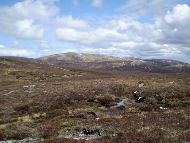
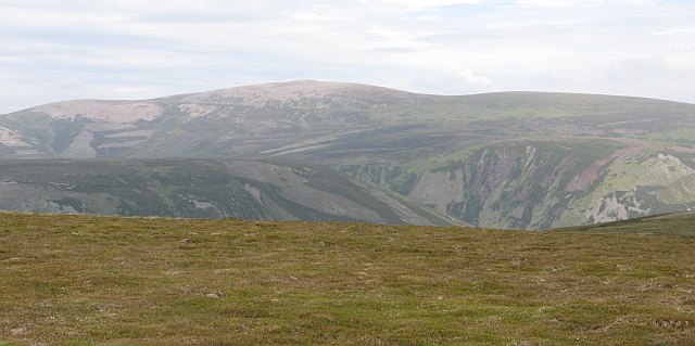
The hill is situated in a remote and rugged area, surrounded by vast moorland and picturesque lochs. It offers stunning panoramic views of the surrounding landscape, including nearby Munros such as Beinn a' Ghlo and Carn Liath. On clear days, it is even possible to see as far as the Cairngorms National Park to the northeast.

Reaching the summit of Beinn Bhreac requires a moderate level of fitness and hillwalking experience. There are several possible routes to the top, ranging from gentle ascents to more challenging and steep sections. Along the way, hikers may encounter a variety of wildlife, including red deer, grouse, and birds of prey.

Due to its isolated location, Beinn Bhreac is an ideal destination for those seeking solitude and a true wilderness experience. The hill offers a sense of tranquility and a chance to connect with nature. However, it is important to come prepared with appropriate clothing, navigation equipment, and respect for the environment.

Overall, Beinn Bhreac is a captivating hill in Perthshire, Scotland, offering breathtaking views, challenging walks, and a peaceful retreat in the heart of nature.

If you have any feedback on the listing, please let us know in the comments section below.

Beinn Bhreac Images

Images are sourced within 2km of 56.915984/-3.8606239 or Grid Reference NN8682. Thanks to Geograph Open Source API. All images are credited.

On top of Beinn Bhreac Looking towards the Cairngorms.
On top of Beinn Bhreac
Looking towards the Cairngorms.
Upper reaches of the Tarf Water
Summit of Beinn Bhreac Looking Northwest at the top of Beinn Bhreac across the Feshie hills. It's a long way from anywhere else on this hill.
Summit of Beinn Bhreac
Looking Northwest at the top of Beinn Bhreac across the Feshie hills. It's a long way from anywhere else on this hill.
View from near top of Beinn Bhreac Looking SE to Loch Mhairc, with Beinn Mheadonach on the right
View from near top of Beinn Bhreac
Looking SE to Loch Mhairc, with Beinn Mheadonach on the right
Beinn Dearg from near Beinn Bhreac Taken from about 150 m SW of Beinn Bhreac cairn, looking SSW towards Beinn Dearg
Beinn Dearg from near Beinn Bhreac
Taken from about 150 m SW of Beinn Bhreac cairn, looking SSW towards Beinn Dearg
View towards Carn Ealar View ENE towards Carn an Fhidhlair / Carn Ealar, with An Sgarsoch just visible to the right.
View towards Carn Ealar
View ENE towards Carn an Fhidhlair / Carn Ealar, with An Sgarsoch just visible to the right.
View towards Cairngorms Cairn at point 837m on Tarf / Feshie watershed, with distant view NE to Cairn Toul, Sgor an Lochain Uaine & Braeriach
View towards Cairngorms
Cairn at point 837m on Tarf / Feshie watershed, with distant view NE to Cairn Toul, Sgor an Lochain Uaine & Braeriach
Tarf headwaters with view to Beinn Dearg View south over headwaters of the Tarf Water towards Beinn Dearg
Tarf headwaters with view to Beinn Dearg
View south over headwaters of the Tarf Water towards Beinn Dearg
The northern end of the ridge of Beinn Bhreac Outcrops of rock and dwarf arctic vegetation, typical of the hilltops here in the southern Cairngorms.
The northern end of the ridge of Beinn Bhreac
Outcrops of rock and dwarf arctic vegetation, typical of the hilltops here in the southern Cairngorms.
Confluence of the Allt na Beinne Brice The Allt na Beinne Brice drains a corrie between Beinn Bhreac and Meall Tionail na Beinne Brice, and joins the Tarf at this rather unremarkable confluence.
Confluence of the Allt na Beinne Brice
The Allt na Beinne Brice drains a corrie between Beinn Bhreac and Meall Tionail na Beinne Brice, and joins the Tarf at this rather unremarkable confluence.
The valley of the upper Tarf Water Looking down into the valley of the Tarf Water, from the slightly peaty southern slopes of Beinn Bhreac.
The valley of the upper Tarf Water
Looking down into the valley of the Tarf Water, from the slightly peaty southern slopes of Beinn Bhreac.
Summit of Beinn Bhreac What the picture doesn't show is that there was a cold wind blowing left to right at 40mph, and it was no place to linger for long.
Summit of Beinn Bhreac
What the picture doesn't show is that there was a cold wind blowing left to right at 40mph, and it was no place to linger for long.
The upper corrie to the east of Beinn Bhreac It doesn't appear to have a name, but this corrie falls away southwards (ie off the righthand side of the picture) towards the Tarf Water, with the Glas Feith Mhòr draining it.
The upper corrie to the east of Beinn Bhreac
It doesn't appear to have a name, but this corrie falls away southwards (ie off the righthand side of the picture) towards the Tarf Water, with the Glas Feith Mhòr draining it.
Beinn Bhreac summit Carn an Fhidhleir and An Sgarsoch are clearly visible in the distance
Beinn Bhreac summit
Carn an Fhidhleir and An Sgarsoch are clearly visible in the distance
Coire Camartaich Looking across the square from the somewhat insignificant Coire Camartaich towards Caisteal a' Choire, another mapped but barely distinguishable feature.
A very young Tarf Water creates a shallow valley to the righthand side of the photo.
Coire Camartaich
Looking across the square from the somewhat insignificant Coire Camartaich towards Caisteal a' Choire, another mapped but barely distinguishable feature. A very young Tarf Water creates a shallow valley to the righthand side of the photo.
The Tarf Water An obvious double bend in the Tarf Water, little over 2km long at this point.
The Tarf Water
An obvious double bend in the Tarf Water, little over 2km long at this point.
Infant Tarf Looking across the Tarf Water from low down on Beinn Bhreac's south west ridge.
Infant Tarf
Looking across the Tarf Water from low down on Beinn Bhreac's south west ridge.
Tarf Water In the north west corner of the square, the Tarf Water is quite easy to cross here being just a few kilometres from its source.
Tarf Water
In the north west corner of the square, the Tarf Water is quite easy to cross here being just a few kilometres from its source.
Show me another place!

Beinn Bhreac is located at Grid Ref: NN8682 (Lat: 56.915984, Lng: -3.8606239)

Unitary Authority: Perth and Kinross

Police Authority: Tayside

What 3 Words

///figs.arming.perused. Near Blair Atholl, Perth & Kinross

Nearby Locations

Beinn Bhreac

Related Wikis

Carn an Fhidhleir

Carn an Fhidhleir (994 m) is a mountain in the Grampian Mountains of Scotland. It lies on the border of Inverness-shire, Perthshire and Aberdeenshire,...

Beinn Dearg (Blair Atholl)

Beinn Dearg (1,009 m) is a mountain in the Grampian Mountains of Scotland. It lies north of the Perth and Kinross village of Blair Atholl, in the Forest...

An Sgarsoch

An Sgarsoch (1,006.5m) is a mountain in the Grampian Mountains of Scotland. It lies north of Blair Atholl in a very remote part of the Highlands, on the...

Carn a' Chlamain

Càrn a' Chlamain (Gaelic: Càrn a' Chlamhain) is a Scottish mountain situated roughly 12 kilometres north of Blair Atholl in the Forest of Atholl. It is...

Nearby Amenities

Located within 500m of 56.915984,-3.8606239
Beinn Bhreac
Corbett: yes
Ele: 912
Graham: no
Marilyn: yes
Munro: no
Natural: peak
Prominence: 171
Source: OS Opendata Streetview
Lat/Long: 56.91643/-3.8609676
The data included in this document is from www.openstreetmap.org. The data is made available under ODbL.

Have you been to Beinn Bhreac?

Leave your review of Beinn Bhreac below (or comments, questions and feedback).