An Sligearnach

Hill, Mountain in Perthshire

Scotland

An Sligearnach

On top of Beinn Bhreac Looking towards the Cairngorms.
On top of Beinn Bhreac Credit: Alan Reid

An Sligearnach, also known as Sliocharnach, is a prominent hill located in Perthshire, Scotland. Standing at an impressive height of 671 meters (2,201 feet), it offers breathtaking panoramic views of the surrounding countryside.

Situated in the southern part of the Cairngorms National Park, An Sligearnach is a popular destination for hikers and nature enthusiasts. Its location provides easy access from the nearby town of Blairgowrie, making it a convenient option for both locals and visitors.

The hill features a relatively gentle ascent, with a well-defined path leading towards the summit. As hikers make their way up, they are likely to encounter diverse flora and fauna, including heather, birch trees, and various bird species. The summit itself offers stunning vistas of the surrounding mountains, valleys, and lochs, making it a rewarding experience for those who reach the top.

It is worth noting that An Sligearnach is not a technically challenging climb, making it suitable for hikers of various skill levels. However, it is always recommended to come prepared with proper hiking equipment, including sturdy footwear and clothing appropriate for the unpredictable Scottish weather.

Overall, An Sligearnach is a picturesque hill in Perthshire that offers a memorable outdoor experience for those who appreciate Scotland's natural beauty. Whether it's a leisurely hike or a more adventurous climb, this hill has something to offer for everyone.

If you have any feedback on the listing, please let us know in the comments section below.

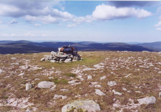
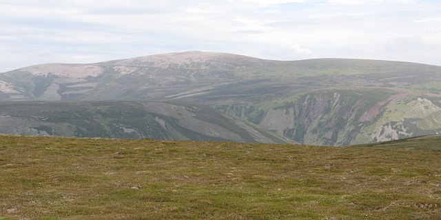
An Sligearnach Images

Images are sourced within 2km of 56.916128/-3.8911372 or Grid Reference NN8482. Thanks to Geograph Open Source API. All images are credited.

On top of Beinn Bhreac Looking towards the Cairngorms.
On top of Beinn Bhreac
Looking towards the Cairngorms.
Summit of Beinn Bhreac Looking Northwest at the top of Beinn Bhreac across the Feshie hills. It's a long way from anywhere else on this hill.
Summit of Beinn Bhreac
Looking Northwest at the top of Beinn Bhreac across the Feshie hills. It's a long way from anywhere else on this hill.
Beinn Dearg from near Beinn Bhreac Taken from about 150 m SW of Beinn Bhreac cairn, looking SSW towards Beinn Dearg
Beinn Dearg from near Beinn Bhreac
Taken from about 150 m SW of Beinn Bhreac cairn, looking SSW towards Beinn Dearg
Tarf headwaters with view to Beinn Dearg View south over headwaters of the Tarf Water towards Beinn Dearg
Tarf headwaters with view to Beinn Dearg
View south over headwaters of the Tarf Water towards Beinn Dearg
Plateau on the Tarf / Feshie watershed View NE towards Cairngorms
Plateau on the Tarf / Feshie watershed
View NE towards Cairngorms
Pt 859 on Bruar / Feshie watershed View ENE towards Beinn Bhrotain
Pt 859 on Bruar / Feshie watershed
View ENE towards Beinn Bhrotain
Summit of Beinn Bhreac What the picture doesn't show is that there was a cold wind blowing left to right at 40mph, and it was no place to linger for long.
Summit of Beinn Bhreac
What the picture doesn't show is that there was a cold wind blowing left to right at 40mph, and it was no place to linger for long.
Beinn Bhreac summit Carn an Fhidhleir and An Sgarsoch are clearly visible in the distance
Beinn Bhreac summit
Carn an Fhidhleir and An Sgarsoch are clearly visible in the distance
Coire Camartaich Looking across the square from the somewhat insignificant Coire Camartaich towards Caisteal a' Choire, another mapped but barely distinguishable feature.
A very young Tarf Water creates a shallow valley to the righthand side of the photo.
Coire Camartaich
Looking across the square from the somewhat insignificant Coire Camartaich towards Caisteal a' Choire, another mapped but barely distinguishable feature. A very young Tarf Water creates a shallow valley to the righthand side of the photo.
The Tarf Water An obvious double bend in the Tarf Water, little over 2km long at this point.
The Tarf Water
An obvious double bend in the Tarf Water, little over 2km long at this point.
Infant Tarf Looking across the Tarf Water from low down on Beinn Bhreac's south west ridge.
Infant Tarf
Looking across the Tarf Water from low down on Beinn Bhreac's south west ridge.
Tarf Water In the north west corner of the square, the Tarf Water is quite easy to cross here being just a few kilometres from its source.
Tarf Water
In the north west corner of the square, the Tarf Water is quite easy to cross here being just a few kilometres from its source.
Rough ground by the Tarf Water A remote peat bog lying between Beinn Dearg to the south and Beinn Bhreac to the north.
Rough ground by the Tarf Water
A remote peat bog lying between Beinn Dearg to the south and Beinn Bhreac to the north.
Cairn, Beinn Bhreac Early morning sunshine on this remote summit with a view towards Beinn Dearg.
Cairn, Beinn Bhreac
Early morning sunshine on this remote summit with a view towards Beinn Dearg.
Eroding peat high on Meall Odhar The name Meall Odhar means Rough Hill; with extensive peat marshes and ground such as this, it's certainly a tough walk and earns its name accordingly. Competency in map-and-compass navigation skills in clag like this is also a top plan.
Eroding peat high on Meall Odhar
The name Meall Odhar means Rough Hill; with extensive peat marshes and ground such as this, it's certainly a tough walk and earns its name accordingly. Competency in map-and-compass navigation skills in clag like this is also a top plan.
Peat bogs and hags high on Meall Odhar
Looking down towards the western side of Meall Odhar This particular part of the hill is clear of the peaty hags that abound elsewhere, and the short turf is a delight to walk on. It doesn't last!
Looking down towards the western side of Meall Odhar
This particular part of the hill is clear of the peaty hags that abound elsewhere, and the short turf is a delight to walk on. It doesn't last!
Back in peat country Despite better ground in parts, the upper flat-topped area of Meall Odhar is a generally peaty place. It would be very hard going in wet weather.
Back in peat country
Despite better ground in parts, the upper flat-topped area of Meall Odhar is a generally peaty place. It would be very hard going in wet weather.
Show me another place!

An Sligearnach is located at Grid Ref: NN8482 (Lat: 56.916128, Lng: -3.8911372)

Unitary Authority: Perth and Kinross

Police Authority: Tayside

What 3 Words

///pupils.lightly.factory. Near Blair Atholl, Perth & Kinross

Nearby Locations

An Sligearnach

Related Wikis

Beinn Dearg (Blair Atholl)

Beinn Dearg (1,009 m) is a mountain in the Grampian Mountains of Scotland. It lies north of the Perth and Kinross village of Blair Atholl, in the Forest...

Carn an Fhidhleir

Carn an Fhidhleir (994 m) is a mountain in the Grampian Mountains of Scotland. It lies on the border of Inverness-shire, Perthshire and Aberdeenshire,...

Grampian Mountains

The Grampian Mountains (Scottish Gaelic: Am Monadh) is one of the three major mountain ranges in Scotland, that together occupy about half of Scotland...

Battle of Craig Cailloch

The Battle of Craig Cailloch was a Scottish clan battle fought in 1441 between the Clan Cameron and Clan Mackintosh (who were part of the Chattan Confederation...

Have you been to An Sligearnach?

Leave your review of An Sligearnach below (or comments, questions and feedback).