Slough Hill
Hill, Mountain in Dumfriesshire
Scotland
Slough Hill

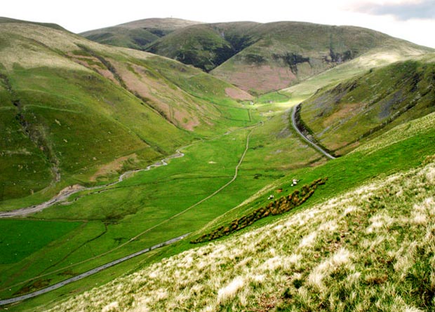
Slough Hill is a prominent feature located in Dumfriesshire, Scotland. It is classified as a hill and stands at an elevation of approximately 470 meters (1,540 feet) above sea level. Situated in the southern part of Dumfriesshire, Slough Hill is part of the Southern Uplands range, which stretches across the Scottish Borders and into Dumfriesshire.
The hill boasts a distinct shape, characterized by a rounded summit and gentle slopes covered with grasses, heather, and scattered rocky outcrops. Its geological composition mainly comprises sandstone and shale, typical of the Southern Uplands. Slough Hill provides breathtaking views of the surrounding countryside, including the rolling hills and valleys that characterize this part of Scotland.
Due to its accessible location and relatively moderate gradient, Slough Hill attracts outdoor enthusiasts and hikers looking for a challenging yet enjoyable ascent. Several footpaths and trails lead to the summit, offering a range of options for various skill levels. The hill's location within the Southern Uplands also makes it a suitable destination for birdwatching, with various species inhabiting the area.
Slough Hill is encompassed by a landscape rich in history and culture. Nearby, visitors can explore historic sites such as castles, ancient burial mounds, and remnants of old settlements, providing a glimpse into the region's fascinating past.
Overall, Slough Hill in Dumfriesshire offers a picturesque and rewarding experience for nature lovers and those seeking to immerse themselves in Scotland's stunning countryside.
If you have any feedback on the listing, please let us know in the comments section below.
Slough Hill Images
Images are sourced within 2km of 55.436284/-3.8232034 or Grid Reference NS8417. Thanks to Geograph Open Source API. All images are credited.


Slough Hill is located at Grid Ref: NS8417 (Lat: 55.436284, Lng: -3.8232034)
Unitary Authority: Dumfries and Galloway
Police Authority: Dumfries and Galloway
What 3 Words
///hoaxes.pranced.nappy. Near Sanquhar, Dumfries & Galloway
Nearby Locations
Related Wikis

Whitecleuch Chain
The Whitecleuch Chain is a large Pictish silver chain that was found in Whitecleuch, Lanarkshire, Scotland in 1869. A high status piece, it is likely to...

Leadhills
Leadhills, originally settled for the accommodation of miners, is a village in South Lanarkshire, Scotland, 5+3⁄4 miles (9.3 km) WSW of Elvanfoot. The...

Scots Mining Company House
The Scots Mining Company House, also known as Woodlands Hall, is an early-18th-century mansion house in Leadhills, South Lanarkshire, Scotland. The house...
Leadhills railway station
Leadhills railway station was opened on 1 October 1901 as the intermediate stop on the Leadhills and Wanlockhead Light Railway and served the lead mining...

Leadhills and Wanlockhead Railway
The Leadhills and Wanlockhead Railway is a 2 ft (610 mm) narrow gauge railway in South Lanarkshire, Scotland. It is laid on the trackbed of the former...

Wanlockhead
Wanlockhead is a village in Dumfries and Galloway, Scotland, nestling in the Lowther Hills and 1 mile (2 kilometres) south of Leadhills at the head of...
Wanlockhead railway station
Wanlockhead railway station was opened on 1 October 1902 as the terminus on the Leadhills and Wanlockhead Light Railway and served the lead mining area...
Lowther Hills
The Lowther Hills, also sometimes known as the Lowthers, are an extensive area of hill country in the Southern Uplands of Scotland, though some sub-ranges...
Nearby Amenities
Located within 500m of 55.436284,-3.8232034Have you been to Slough Hill?
Leave your review of Slough Hill below (or comments, questions and feedback).