Beinn Losgarnaich

Hill, Mountain in Perthshire

Scotland

Beinn Losgarnaich

Camp by the Allt a' Chuil Thankful to find a passable spot to camp after a trying crossing of the watershed from the Tarf to Glen Bruar in wet snow. The tent is a Saunders Dalomite.
Camp by the Allt a' Chuil Credit: Jim Barton

Beinn Losgarnaich is a prominent hill located in Perthshire, Scotland. It is part of the Southern Highlands and is situated in the Loch Rannoch and Glen Lyon area. With an elevation of 901 meters (2,956 feet), it is classified as a Corbett, a term used to describe Scottish hills between 2,500 and 3,000 feet.

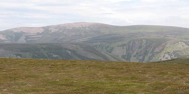
The hill offers breathtaking panoramic views of the surrounding landscape, including the picturesque Loch Rannoch and the nearby Munros, such as Schiehallion. Its location provides excellent opportunities for hillwalking and hiking enthusiasts to explore the natural beauty of the area.

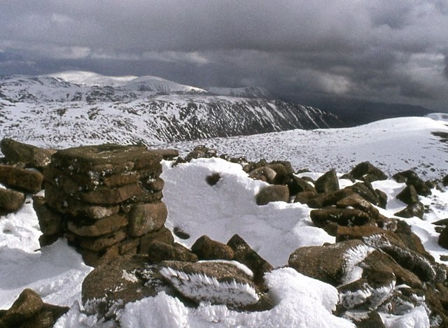
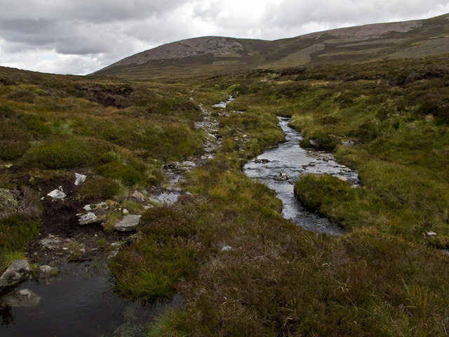
Beinn Losgarnaich is known for its rugged and rocky terrain, making it a challenging climb. The ascent typically starts from the small hamlet of Bridge of Balgie, where walkers can follow a well-defined path that gradually leads to the summit. Along the way, climbers may encounter some boggy patches, but the reward of reaching the peak makes the effort worthwhile.

The summit of Beinn Losgarnaich offers stunning views across the surrounding mountains and glens, providing a magnificent vantage point for photographers and nature enthusiasts. On clear days, it is possible to see as far as the Ben Lawers range and the rugged peaks of Glen Lyon.

Overall, Beinn Losgarnaich is a popular destination for outdoor enthusiasts seeking a challenging and rewarding hillwalking experience. Its striking natural beauty, combined with its accessible location, makes it a must-visit for those exploring the Perthshire region.

If you have any feedback on the listing, please let us know in the comments section below.

Beinn Losgarnaich Images

Images are sourced within 2km of 56.886697/-3.9061795 or Grid Reference NN8378. Thanks to Geograph Open Source API. All images are credited.

Camp by the Allt a' Chuil Thankful to find a passable spot to camp after a trying crossing of the watershed from the Tarf to Glen Bruar in wet snow. The tent is a Saunders Dalomite.
Camp by the Allt a' Chuil
Thankful to find a passable spot to camp after a trying crossing of the watershed from the Tarf to Glen Bruar in wet snow. The tent is a Saunders Dalomite.
The Atholl Beinn Dearg This hill, although high is often rather retiring in views but really stands out from the south of Glen Errochty. The summit is a light pink in colour due to the granite but I have only ever visited it in Winter.
The Atholl Beinn Dearg
This hill, although high is often rather retiring in views but really stands out from the south of Glen Errochty. The summit is a light pink in colour due to the granite but I have only ever visited it in Winter.
Western slopes of Beinn Dearg
Path towards the summit of Beinn Dearg
Trig point atop Beinn Dearg
Rounded boulders at summit area of Beinn Dearg Beinn Dearg, meaning red hill is a fairly common name around the Highland mountains; this example is one of the more remote of them. The name comes from the pink granite boulders which cover the summit area and lie in rashes over the surrounding ground.
In the distance, on the horizon, is the range of Beinn a' Ghlo which has three Munros.
Nearer are two long ridges, those of Carn a' Chlamain and Beinn Mheadhonach.
Rounded boulders at summit area of Beinn Dearg
Beinn Dearg, meaning red hill is a fairly common name around the Highland mountains; this example is one of the more remote of them. The name comes from the pink granite boulders which cover the summit area and lie in rashes over the surrounding ground. In the distance, on the horizon, is the range of Beinn a' Ghlo which has three Munros. Nearer are two long ridges, those of Carn a' Chlamain and Beinn Mheadhonach.
Summit of Beinn Dearg
The summit of Beinn Dearg
Rounded boulders on Beinn Gharbh Beinn Gharbh is a northern top of the Munro, Beinn Dearg, its summit area is covered with rounded boulders of pink granite.
Rounded boulders on Beinn Gharbh
Beinn Gharbh is a northern top of the Munro, Beinn Dearg, its summit area is covered with rounded boulders of pink granite.
Moorland below Beinn Gharbh Wet moorland below Beinn Gharbh.  Usually hill walkers find the quality of ground underfoot decreases with height and this is certainly the case when dropping north from Beinn Dearg towards the Tarf Water, as close cropped heather gives way to rough grassland, which gives way to deep heather and peat haggs.
Moorland below Beinn Gharbh
Wet moorland below Beinn Gharbh. Usually hill walkers find the quality of ground underfoot decreases with height and this is certainly the case when dropping north from Beinn Dearg towards the Tarf Water, as close cropped heather gives way to rough grassland, which gives way to deep heather and peat haggs.
North of Beinn Dearg North of the summit of Beinn Dearg (Red Hill), showing the reddish granite scree which gives the peak its name.
North of Beinn Dearg
North of the summit of Beinn Dearg (Red Hill), showing the reddish granite scree which gives the peak its name.
Beinn Dearg The summit area of Beinn Dearg (Red Hill), with reddish granite boulders and scree that give the peak its name.
Beinn Dearg
The summit area of Beinn Dearg (Red Hill), with reddish granite boulders and scree that give the peak its name.
Path near Beinn Losgarnaich A path above the Allt Beinn Losgarnaich that can be used for an ascent of Beinn Dearg. Beinn Gharbh and the northern flank of Beinn Dearg can be seen in the background.
Path near Beinn Losgarnaich
A path above the Allt Beinn Losgarnaich that can be used for an ascent of Beinn Dearg. Beinn Gharbh and the northern flank of Beinn Dearg can be seen in the background.
Waterfall on the Allt Beinn Losgarnaich One of a number of waterfalls on the Allt Beinn Losgarnaich.
Waterfall on the Allt Beinn Losgarnaich
One of a number of waterfalls on the Allt Beinn Losgarnaich.
Path on Beinn Losgarnaich A path along the flank of Beinn Losgarnaich - this can be used to gain access to the northern slopes of Beinn Dearg.
Path on Beinn Losgarnaich
A path along the flank of Beinn Losgarnaich - this can be used to gain access to the northern slopes of Beinn Dearg.
Pony path, Glen Bruar The path above Allt Beinn Losgarnaich was built to cut a corner at the head of Glen Bruar and provide access to a large boggy area to the west of the Tarf. I passed this way once on the way to Beinn Bhreac and Carn an Fhidhleir.
Pony path, Glen Bruar
The path above Allt Beinn Losgarnaich was built to cut a corner at the head of Glen Bruar and provide access to a large boggy area to the west of the Tarf. I passed this way once on the way to Beinn Bhreac and Carn an Fhidhleir.
Glen Bruar, Ruigh nan Gaoithe The road runs up to the end of the glen before the Minigaig reverts to the old path through the heather.
Glen Bruar, Ruigh nan Gaoithe
The road runs up to the end of the glen before the Minigaig reverts to the old path through the heather.
Allt Creag na h-Iolair A burn descending steep slopes into Glen Bruar.
Allt Creag na h-Iolair
A burn descending steep slopes into Glen Bruar.
Show me another place!

Beinn Losgarnaich is located at Grid Ref: NN8378 (Lat: 56.886697, Lng: -3.9061795)

Unitary Authority: Perth and Kinross

Police Authority: Tayside

What 3 Words

///loopholes.animal.scaffold. Near Blair Atholl, Perth & Kinross

Related Wikis

Beinn Dearg (Blair Atholl)

Beinn Dearg (1,009 m) is a mountain in the Grampian Mountains of Scotland. It lies north of the Perth and Kinross village of Blair Atholl, in the Forest...

Forest of Atholl

The Forest of Atholl (also known as Atholl Forest) is a deer forest near the Scottish village of Blair Atholl, Perth and Kinross, first recorded in the...

Grampian Mountains

The Grampian Mountains (Scottish Gaelic: Am Monadh) is one of the three major mountain ranges in Scotland, that together occupy about half of Scotland...

Carn a' Chlamain

Càrn a' Chlamain (Gaelic: Càrn a' Chlamhain) is a Scottish mountain situated roughly 12 kilometres north of Blair Atholl in the Forest of Atholl. It is...

Have you been to Beinn Losgarnaich?

Leave your review of Beinn Losgarnaich below (or comments, questions and feedback).