Bryn Daith

Hill, Mountain in Montgomeryshire

Wales

Bryn Daith

Sweet Lamb Rally Stage (WRC)
Sweet Lamb Rally Stage (WRC) Credit: Brian Deegan

The requested URL returned error: 429 Too Many Requests

If you have any feedback on the listing, please let us know in the comments section below.
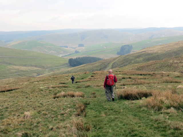
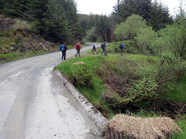
Bryn Daith Images

Images are sourced within 2km of 52.457829/-3.7221417 or Grid Reference SN8385. Thanks to Geograph Open Source API. All images are credited.

Sweet Lamb Rally Stage (WRC)
Sweet Lamb WRC 2016
Sweet Lamb WRC 2016
Sgwt Afon Hore / Afon Hore Waterfall Sgwt ar Afon Hore, rhagnant Afon Hafren.

A waterfall on the Afon Hore, a tributary of the Severn River.
Sgwt Afon Hore / Afon Hore Waterfall
Sgwt ar Afon Hore, rhagnant Afon Hafren. A waterfall on the Afon Hore, a tributary of the Severn River.
Cwm Hore / Hore Valley Edrych i lawr ar Gwm Hore.

Looking down on the Hore Valley
Cwm Hore / Hore Valley
Edrych i lawr ar Gwm Hore. Looking down on the Hore Valley
Llethrau is Pumlumon Arwystli /  Lowers slopes of Pumlumon Arwystli Cerddwyr ar lethrau isaf Pumlumon Arwystli. 


Walkers on the lower slopes of Pumlumon Arwystli.
Llethrau is Pumlumon Arwystli / Lowers slopes of Pumlumon Arwystli
Cerddwyr ar lethrau isaf Pumlumon Arwystli. Walkers on the lower slopes of Pumlumon Arwystli.
Coed Hafren / Hafren Forest Cerddwyr yn gadael y trac coedwigoedd.

Walkers leaving the forestry track.
Coed Hafren / Hafren Forest
Cerddwyr yn gadael y trac coedwigoedd. Walkers leaving the forestry track.
Coed Hafren / Hafren Forest Cerddwyr yn dilyn llwybr yng Nghoed Hafren.

Walkers following a path at Hafren Forest.
Coed Hafren / Hafren Forest
Cerddwyr yn dilyn llwybr yng Nghoed Hafren. Walkers following a path at Hafren Forest.
Afon Gwy flows down from its source on the Plynlimon range A meteorological station is visible on the right of the river.
Afon Gwy flows down from its source on the Plynlimon range
A meteorological station is visible on the right of the river.
Ford in Sweet Lamb Rally Complex
Gravel roads in Sweet Lamb Rally Complex
A view over the Sweet Lamb motor rally complex The cwm in the forefront of the view is the source of the River Wye. The lower of the two visible groups of buildings is a staging point for rally events (see <a href="https://www.geograph.org.uk/photo/470913">SN8285 : Sweet Lamb Motor Sports Complex</a>). Slightly behind and to its right is Y Drum. Behind Y Drum is Y Foel (546 metres).
A view over the Sweet Lamb motor rally complex
The cwm in the forefront of the view is the source of the River Wye. The lower of the two visible groups of buildings is a staging point for rally events (see SN8285 : Sweet Lamb Motor Sports Complex). Slightly behind and to its right is Y Drum. Behind Y Drum is Y Foel (546 metres).
Esgair y Maen Viewed from the Pumlumon ridge. The rally track that circumnavigates part of the hill is visible.
Esgair y Maen
Viewed from the Pumlumon ridge. The rally track that circumnavigates part of the hill is visible.
The Sweet Lamb rally track climbs Esgair y Maen The track is dedicated to Rally driving in the Sweet Lamb motor sport complex. The stile at bottom right is on the footpath from Cripiau Eisteddfa-fach to Esgair y Maen. This side of the fence is access land - over the stile is not, but the right of way continues through the Sweet Lamb complex and onto Hafren Forest to the north or Pont Rhydgaled to the south.
The Sweet Lamb rally track climbs Esgair y Maen
The track is dedicated to Rally driving in the Sweet Lamb motor sport complex. The stile at bottom right is on the footpath from Cripiau Eisteddfa-fach to Esgair y Maen. This side of the fence is access land - over the stile is not, but the right of way continues through the Sweet Lamb complex and onto Hafren Forest to the north or Pont Rhydgaled to the south.
A view towards Pen Pumlumon Arwystli from the Wye Valley Walk in Hafren Forest
Track into Cerrig yr Wyn Local signs show this track also to be a permissive path to the source of the Wye. Now that the area is access land, I'm not sure that the concept of permissive path is relevant in this particular case. See also <a href="https://www.geograph.org.uk/photo/2480679">SN8286 : Permissive Path sign to Cerrig yr Wyn</a>.
Track into Cerrig yr Wyn
Local signs show this track also to be a permissive path to the source of the Wye. Now that the area is access land, I'm not sure that the concept of permissive path is relevant in this particular case. See also SN8286 : Permissive Path sign to Cerrig yr Wyn.
Permissive Path sign to Cerrig yr Wyn The sign reads "Permissive Path to viewpoint of Source of Wye 1km". See also comment for <a href="https://www.geograph.org.uk/photo/2480663">SN8286 : Track into Cerrig yr Wyn</a>.
Permissive Path sign to Cerrig yr Wyn
The sign reads "Permissive Path to viewpoint of Source of Wye 1km". See also comment for SN8286 : Track into Cerrig yr Wyn.
The boundary between Sweet Lamb and Hafren Forest The road forms the Wye Valley walk here being viewed from the Sweet Lamb estate into Hafren Forest. A 'Pedestrians in road' sign can be seen on the right.
The boundary between Sweet Lamb and Hafren Forest
The road forms the Wye Valley walk here being viewed from the Sweet Lamb estate into Hafren Forest. A 'Pedestrians in road' sign can be seen on the right.
Notice warning of shooting in progress A very reasonable notice warning that shooting may be taking place in this part of the Sweet Lamb estate. None was happening whilst I was there.
Notice warning of shooting in progress
A very reasonable notice warning that shooting may be taking place in this part of the Sweet Lamb estate. None was happening whilst I was there.
Show me another place!

Bryn Daith is located at Grid Ref: SN8385 (Lat: 52.457829, Lng: -3.7221417)

Unitary Authority: Powys

Police Authority: Dyfed Powys

What 3 Words

///lease.inclines.lordship. Near Staylittle, Powys

Nearby Locations

Bryn Daith

Related Wikis

Mwyngloddfa Nantiago

Mwyngloddfa Nantiago is a Site of Special Scientific Interest in Brecknock, Powys, Wales. It is located on the eastern flank of the Plynlimon range of...

Pen Pumlumon Arwystli

Pen Pumlumon Arwystli is the second highest summit on the Plynlimon massif, a part of the Cambrian Mountains in the county of Ceredigion, Wales. The summit...

Hafren Forest

Hafren Forest lies north-west of Llanidloes, an ancient market town in Mid Wales. == Overview == The forest covers around 40 square kilometres (15 square...

Pen Pumlumon Llygad-bychan

Pen Pumlumon Llygad-bychan is a subsidiary summit of Pen Pumlumon Fawr and the third highest summit on the Plynlimon massif, a part of the Cambrian Mountains...

Nearby Amenities

Located within 500m of 52.457829,-3.7221417
The data included in this document is from www.openstreetmap.org. The data is made available under ODbL.

Have you been to Bryn Daith?

Leave your review of Bryn Daith below (or comments, questions and feedback).