Cairn Kincraig

Hill, Mountain in Nairnshire

Scotland

Cairn Kincraig

The Very Flat Summit of Cairn Kincraig This is an odd hill. First off, its name implies some kind of craggy splendour, which is nowhere in sight - it is just heather and peat here! Secondly, the hill is marked on all maps by its Western end, from where this picture was taken. According to different scale OS maps its highest point at this Western side is either 556 or 557 metres, and is either at the point this picture was taken  from or a short distance across the fence, respectively.
All maps show the highest point further East at 559 metres though, and this point can be seen in the picture. It is a fairly long plateau at the summit so why they choose to only give a hill name to the lower bump I do not know.
This is my first 'first geograph'. I knew I had crossed an unlogged one at some point on this trip but couldn't remember where. However, when I noticed a new member operating in Scotland who only collects first geographs I decided I'd best find it and upload in case they steal my glory!
A quick calculation shows that if you were to collect grid-squares from the age of 10 to 90 you would have to visit and photograph just over 11 new ones every day over those 80 years to complete the set - will there ever be Geographists?!
The Very Flat Summit of Cairn Kincraig Credit: Ian Dodds

Cairn Kincraig is a prominent hill located in Nairnshire, a county in the Highland region of Scotland. It is situated approximately 10 miles southeast of the town of Nairn and rises to an elevation of 364 meters (1,194 feet).

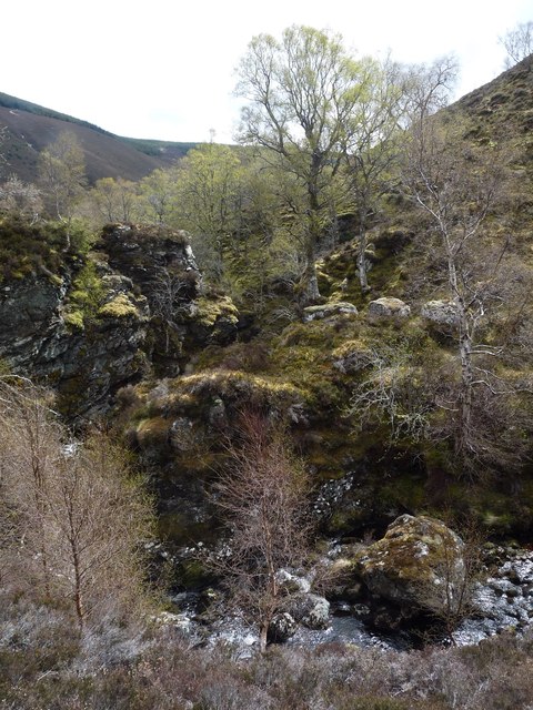
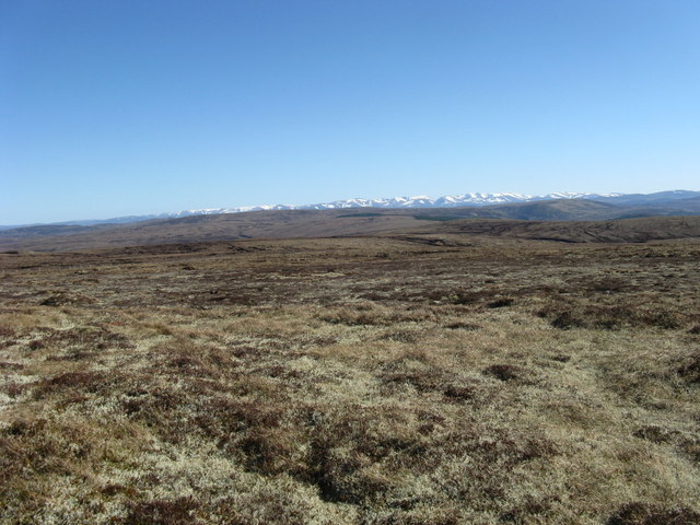
This hill is known for its distinctive shape and rugged terrain, making it a popular destination for hikers and outdoor enthusiasts. The ascent to the summit of Cairn Kincraig is moderately challenging, but the effort is rewarded with breathtaking panoramic views of the surrounding countryside, including the nearby Moray Firth and the distant peaks of the Scottish Highlands.

The hill is covered in heather and grasses, providing habitat for a variety of wildlife such as red deer, mountain hares, and numerous bird species. It is also home to a diverse range of plant life, including wildflowers and ferns.

Cairn Kincraig holds historical significance as well, with remnants of ancient settlements and burial cairns found in its vicinity. These archaeological features add an intriguing element to the hill's charm and attract history enthusiasts.

Visitors to Cairn Kincraig are advised to come prepared with appropriate clothing and footwear, as the weather conditions can change quickly. Additionally, it is important to respect the natural environment and adhere to any local guidelines or regulations to ensure the preservation of this stunning landscape.

If you have any feedback on the listing, please let us know in the comments section below.

Cairn Kincraig Images

Images are sourced within 2km of 57.404522/-3.9485516 or Grid Reference NH8336. Thanks to Geograph Open Source API. All images are credited.

The Very Flat Summit of Cairn Kincraig This is an odd hill. First off, its name implies some kind of craggy splendour, which is nowhere in sight - it is just heather and peat here! Secondly, the hill is marked on all maps by its Western end, from where this picture was taken. According to different scale OS maps its highest point at this Western side is either 556 or 557 metres, and is either at the point this picture was taken  from or a short distance across the fence, respectively.
All maps show the highest point further East at 559 metres though, and this point can be seen in the picture. It is a fairly long plateau at the summit so why they choose to only give a hill name to the lower bump I do not know.
This is my first 'first geograph'. I knew I had crossed an unlogged one at some point on this trip but couldn't remember where. However, when I noticed a new member operating in Scotland who only collects first geographs I decided I'd best find it and upload in case they steal my glory!
A quick calculation shows that if you were to collect grid-squares from the age of 10 to 90 you would have to visit and photograph just over 11 new ones every day over those 80 years to complete the set - will there ever be Geographists?!
The Very Flat Summit of Cairn Kincraig
This is an odd hill. First off, its name implies some kind of craggy splendour, which is nowhere in sight - it is just heather and peat here! Secondly, the hill is marked on all maps by its Western end, from where this picture was taken. According to different scale OS maps its highest point at this Western side is either 556 or 557 metres, and is either at the point this picture was taken from or a short distance across the fence, respectively. All maps show the highest point further East at 559 metres though, and this point can be seen in the picture. It is a fairly long plateau at the summit so why they choose to only give a hill name to the lower bump I do not know. This is my first 'first geograph'. I knew I had crossed an unlogged one at some point on this trip but couldn't remember where. However, when I noticed a new member operating in Scotland who only collects first geographs I decided I'd best find it and upload in case they steal my glory! A quick calculation shows that if you were to collect grid-squares from the age of 10 to 90 you would have to visit and photograph just over 11 new ones every day over those 80 years to complete the set - will there ever be Geographists?!
Layers of river terraces below Tom na Slaite
A tight rocky gorge above Shenachie
Birches on an old river terrace
Birch clad bank at Shenachie
River Findhorn at Shenachie
Moorland south of Cnoc a' Chinn Leith Looking across unnamed tributaries of Ballaggan Burn.
Moorland south of Cnoc a' Chinn Leith
Looking across unnamed tributaries of Ballaggan Burn.
Slopes south of Cnoc a' Chinn Leith Looking across an unnamed tributary of Ballaggan Burn towards An Seileach.
Slopes south of Cnoc a' Chinn Leith
Looking across an unnamed tributary of Ballaggan Burn towards An Seileach.
South side of Carn nan Tri-tighearnan A glorious Good Friday with extensive views in all directions and the feeling of a "big" sky. Looking south towards the snow covered Cairngorm Mountains.
South side of Carn nan Tri-tighearnan
A glorious Good Friday with extensive views in all directions and the feeling of a "big" sky. Looking south towards the snow covered Cairngorm Mountains.
Ropeway at Shenachie The only way in this area to cross the fierce Findhorn river.  Sadly, no operating handle is left around, so we had to take a spine-tingling contour path through the gorge.  But think about it - you would need TWO handles to get all across the ropeway!
Ropeway at Shenachie
The only way in this area to cross the fierce Findhorn river. Sadly, no operating handle is left around, so we had to take a spine-tingling contour path through the gorge. But think about it - you would need TWO handles to get all across the ropeway!
Ruined Shenachie
Ruined Shenachie
The start of the traverse There is a fairly hair-raising path which contours along the very steep ground below Creag a Chrochain on the west bank of the Findhorn.  The path starts just at the bottom left of this photograph.
The start of the traverse
There is a fairly hair-raising path which contours along the very steep ground below Creag a Chrochain on the west bank of the Findhorn. The path starts just at the bottom left of this photograph.
The path from Shenachie to Daless Not for the faint-hearted as it contours above the Findhorn.
The path from Shenachie to Daless
Not for the faint-hearted as it contours above the Findhorn.
One of the Findhorn gorges The path back to Shenachie can just be made out snaking up the hillside from the scree patch
One of the Findhorn gorges
The path back to Shenachie can just be made out snaking up the hillside from the scree patch
The track to Daless River Findhorn to the right.
The track to Daless
River Findhorn to the right.
Ballachrochin from the Daless track River Findhorn in the foreground
Ballachrochin from the Daless track
River Findhorn in the foreground
Flat ground beside the Findhorn The small hut is a fishing hut on the river bank.
Flat ground beside the Findhorn
The small hut is a fishing hut on the river bank.
Tributary of the Allt Odhar
Show me another place!

Cairn Kincraig is located at Grid Ref: NH8336 (Lat: 57.404522, Lng: -3.9485516)

Unitary Authority: Highland

Police Authority: Highlands and Islands

What 3 Words

///open.saloons.lotteries. Near Balloch, Highland

Nearby Locations

Cairn Kincraig

Related Wikis

Inverness, Nairn, Badenoch and Strathspey (UK Parliament constituency)

Inverness, Nairn, Badenoch and Strathspey is a constituency of the House of Commons of the UK Parliament. As with all seats since 1950 it elects one Member...

Balvraid

Balvraid (Scottish Gaelic: Baile a' Bhràghaid) is a small remote settlement, located 8 miles south east of Inverness in Inverness-shire, Scottish Highlands...

Loch Moy

Loch Moy (from the Scottish Gaelic Loch A'Mhoigh meaning the Loch of the Plain) is a freshwater loch beside the village of Moy near Inverness in the Scottish...

Moy Hall

Moy Hall near the village of Moy, south of Inverness, is the home of the chiefs of the Clan Mackintosh, a Highland Scottish clan. == History == The original...

Have you been to Cairn Kincraig?

Leave your review of Cairn Kincraig below (or comments, questions and feedback).