Carn Dearg Mòr

Hill, Mountain in Inverness-shire

Scotland

Carn Dearg Mòr

Forestry extraction near Carn Dearg, Glenfeshie Indicated as a single track on OS, a large vehicular track now exists for tree extraction / planting (pictured).
Forestry extraction near Carn Dearg, Glenfeshie Credit: Kim McGillivray

Carn Dearg Mòr, located in Inverness-shire, Scotland, is a prominent hill/mountain that stands at an elevation of 945 meters (3,100 feet). It is part of the Cairngorms National Park and is situated in the western part of the park, near the village of Laggan.

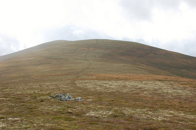
The mountain is characterized by its distinctive shape and rugged terrain, making it a popular destination for outdoor enthusiasts, hikers, and mountaineers. It offers breathtaking views of the surrounding landscape, including the nearby Loch Laggan and the Grampian Mountains.

Carn Dearg Mòr is predominantly composed of granite, which adds to its dramatic appearance. Its slopes are covered with heather, grasses, and scattered boulders, creating a picturesque setting. The mountain is also home to diverse wildlife, including red deer, mountain hares, and golden eagles, making it a haven for nature lovers.

The ascent to the summit of Carn Dearg Mòr can be challenging, especially in winter when the mountain is often covered in snow and ice. However, experienced climbers can enjoy the thrill of reaching the top and being rewarded with panoramic views of the surrounding area.

Due to its location within the Cairngorms National Park, the mountain is well-preserved, and visitors are urged to respect the natural environment and follow the designated paths and trails. It is advised to come prepared with appropriate clothing, equipment, and navigational tools, as weather conditions can change rapidly in the Scottish Highlands.

If you have any feedback on the listing, please let us know in the comments section below.

Carn Dearg Mòr Images

Images are sourced within 2km of 56.996639/-3.938519 or Grid Reference NN8291. Thanks to Geograph Open Source API. All images are credited.

Forestry extraction near Carn Dearg, Glenfeshie Indicated as a single track on OS, a large vehicular track now exists for tree extraction / planting (pictured).
Forestry extraction near Carn Dearg, Glenfeshie
Indicated as a single track on OS, a large vehicular track now exists for tree extraction / planting (pictured).
Forestry track near Carn Dearg, above Glenfeshie Indicated as single track on OS maps, a vehicular track now exists for nearby forestry activities.
Forestry track near Carn Dearg, above Glenfeshie
Indicated as single track on OS maps, a vehicular track now exists for nearby forestry activities.
Watershed between Glenfeshie & Glen Tromie Looking south towards An Eilrig summit, from forestry track.
Watershed between Glenfeshie & Glen Tromie
Looking south towards An Eilrig summit, from forestry track.
Forestry block with Carn Dearg in the background
Track through Slochd Mor to Glen Feshie Track between Glen Tromie to Glenfeshie, rideable by bicycle.
Track through Slochd Mor to Glen Feshie
Track between Glen Tromie to Glenfeshie, rideable by bicycle.
Glen Feshie viewed from Slochd Mor track
Slochd Mor The view at Glenfeshie. Glen Tromie (10km away) can be reached by this track.
Slochd Mor
The view at Glenfeshie. Glen Tromie (10km away) can be reached by this track.
Track to Glen Feshie The track through the Slochd Mor between Carn Mor Dearg (L) and Sron na h-Iolaire, out of shot to the right.
Track to Glen Feshie
The track through the Slochd Mor between Carn Mor Dearg (L) and Sron na h-Iolaire, out of shot to the right.
Across the forest to Sloch Beag 'Slochd' is a hollow, so this narrow glen appears as a small hollow in the hillsides flanking Glen Feshie. Seen from the path above Auchlea.
Across the forest to Sloch Beag
'Slochd' is a hollow, so this narrow glen appears as a small hollow in the hillsides flanking Glen Feshie. Seen from the path above Auchlea.
Across the Feshie A view across the river to the track through the narrow glen that passes Lochan an t-Stuic.
Across the Feshie
A view across the river to the track through the narrow glen that passes Lochan an t-Stuic.
Confluence on Allt Coire nam Mart near Glen Feshie The tributary just boiled up at the side of Allt Coire nam Mart from a burial deep in moss and grass.
Confluence on Allt Coire nam Mart near Glen Feshie
The tributary just boiled up at the side of Allt Coire nam Mart from a burial deep in moss and grass.
Course of tributary to Allt Coire nam Mart near Glen Feshie Stream buried in moss and grass.
Course of tributary to Allt Coire nam Mart near Glen Feshie
Stream buried in moss and grass.
Allt Coire nam Mart near Glen Feshie Immediately upstream of the confluence.
Allt Coire nam Mart near Glen Feshie
Immediately upstream of the confluence.
Looking down the course of Allt Coire nam Mart near Glen Feshie
Upstream on Allt nam Coire Mart near Glen Feshie
East bank of Allt nam Coire Mart near Glen Feshie Behind is the catchment of the tributary just downstream.
East bank of Allt nam Coire Mart near Glen Feshie
Behind is the catchment of the tributary just downstream.
Allt Coire nam Mart near Glen Feshie
Course of tributary joining Allt nam Coire Mart from slopes of Carn Dearg Mor
Show me another place!

Carn Dearg Mòr is located at Grid Ref: NN8291 (Lat: 56.996639, Lng: -3.938519)

Unitary Authority: Highland

Police Authority: Highlands and Islands

What 3 Words

///broads.poses.passes. Near Kingussie, Highland

Nearby Locations

Carn Dearg Mòr

Related Wikis

Càrn Dearg Mòr

Carn Dearg Mor (857 m) is a mountain in the Grampian Mountains of Scotland. It lies in the Badenoch and Strathspey area of Inverness-shire, east of the...

Kingdom of Scotland

The Kingdom of Scotland (Scottish Gaelic: Rìoghachd na h-Alba; Scots: Kinrick o Scotland, Norn: Kongungdum Skotland) was a sovereign state in northwest...

Scotland

Scotland (Scots: Scotland; Scottish Gaelic: Alba [ˈal̪ˠapə] ) is a country that is part of the United Kingdom. It contains nearly one-third of the United...

Battle of Craig Cailloch

The Battle of Craig Cailloch was a Scottish clan battle fought in 1441 between the Clan Cameron and Clan Mackintosh (who were part of the Chattan Confederation...

Mullach Clach a' Bhlàir

Mullach Clach a' Bhlàir or Meall Tional is a Munro in the Cairngorm mountain range of Scotland. == Sources ==

Grampian Mountains

The Grampian Mountains (Scottish Gaelic: Am Monadh) is one of the three major mountain ranges in Scotland, that together occupy about half of Scotland...

Nearby Amenities

Located within 500m of 56.996639,-3.938519
Càrn Dearg Mòr
Corbett: yes
Ele: 857
Graham: no
Marilyn: yes
Munro: no
Natural: peak
Prominence: 292
Wikidata: Q3009623
Wikipedia: en:Càrn Dearg Mòr
Lat/Long: 56.9968975/-3.9387771
The data included in this document is from www.openstreetmap.org. The data is made available under ODbL.

Have you been to Carn Dearg Mòr?

Leave your review of Carn Dearg Mòr below (or comments, questions and feedback).