Bennan

Hill, Mountain in Kirkcudbrightshire

Scotland

Bennan

Benchmark at Turner's Monument An old, worn, benchmark at Turner's Monument.
This photo was taken on the 10th.Sept.2022.
Benchmark at Turner's Monument Credit: Rab McMurdo

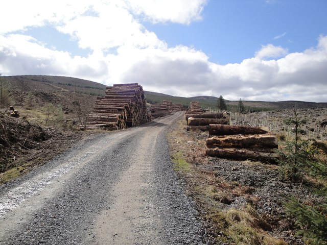
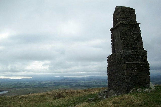
Bennan is a hill located in Kirkcudbrightshire, Scotland. It is a prominent feature in the Galloway Hills and is part of the Southern Uplands range. Standing at a height of 1,719 feet (524 meters), Bennan offers stunning panoramic views of the surrounding countryside and coastline.

The hill is popular among hikers and outdoor enthusiasts, with several well-maintained trails leading to the summit. The terrain is rugged and challenging, with steep ascents and rocky outcrops along the way. However, the effort is rewarded with breathtaking vistas of the rolling hills, forests, and lochs below.

Bennan is home to a variety of wildlife, including birds of prey such as buzzards and golden eagles, as well as red deer and mountain hares. The hill is also rich in plant life, with heather, bracken, and mosses covering the slopes.

Overall, Bennan is a beautiful and rugged natural landmark in Kirkcudbrightshire, offering visitors the chance to experience the beauty and tranquility of the Scottish countryside.

If you have any feedback on the listing, please let us know in the comments section below.

Bennan Images

Images are sourced within 2km of 55.073288/-3.8467993 or Grid Reference NX8276. Thanks to Geograph Open Source API. All images are credited.

Benchmark at Turner's Monument An old, worn, benchmark at Turner's Monument.
This photo was taken on the 10th.Sept.2022.
Benchmark at Turner's Monument
An old, worn, benchmark at Turner's Monument. This photo was taken on the 10th.Sept.2022.
Small Lochan near Glenkiln A small overgrown man-made lochan near Glenkiln.
Small Lochan near Glenkiln
A small overgrown man-made lochan near Glenkiln.
Outbuildings at The Glen Farm All buildings on this large well maintained estate are painted pink.
Outbuildings at The Glen Farm
All buildings on this large well maintained estate are painted pink.
Benchmark at base of the Turner Monument Pivot benchmark at the base of the Turner monument on Bennan. The mark is shown on the 1854 6" map, but none thereafter - <span class="nowrap"><a title="https://www.bench-marks.org.uk/bm139345" rel="nofollow ugc noopener" href="https://www.bench-marks.org.uk/bm139345">Link</a><img style="margin-left:2px;" alt="External link" title="External link - shift click to open in new window" src="https://s1.geograph.org.uk/img/external.png" width="10" height="10"/></span>
Benchmark at base of the Turner Monument
Pivot benchmark at the base of the Turner monument on Bennan. The mark is shown on the 1854 6" map, but none thereafter - LinkExternal link
Forestry Track in Shalloch Forest Looking eastwards with Bishop Forest Hill in the distance
Forestry Track in Shalloch Forest
Looking eastwards with Bishop Forest Hill in the distance
Stacks of felled trees Forestry track west of Shalloch Farm
Stacks of felled trees
Forestry track west of Shalloch Farm
Moorland on Bennan Bennan, a 'Marilyn', rises on the south-west side of Glen Kiln. The distant hill - Bishop Forest Hill - is also a Marilyn.
Moorland on Bennan
Bennan, a 'Marilyn', rises on the south-west side of Glen Kiln. The distant hill - Bishop Forest Hill - is also a Marilyn.
Wall crossing slope of Bennan Bennan is a moorland summit topped by the Turner Monument from which this image was recorded. Bishop Forest Hill lies beyond, across Glen Kiln.
Wall crossing slope of Bennan
Bennan is a moorland summit topped by the Turner Monument from which this image was recorded. Bishop Forest Hill lies beyond, across Glen Kiln.
Bennan, Turner's Monument Parked past the pink Glen Farm on left below small conifer clump on right then through 2 gates then NW to summit over easy grass and occasional heather.
Name: Bennan
Hill number: 1788
Height: 398m / 1306ft
Area: 27C: The Glenkens to Annandale
Class: Ma
Grid ref: NX 82186 76963
Summit feature: Turner's Monument
Drop: 186m
Col: 212m  NX784828
Bennan, Turner's Monument
Parked past the pink Glen Farm on left below small conifer clump on right then through 2 gates then NW to summit over easy grass and occasional heather. Name: Bennan Hill number: 1788 Height: 398m / 1306ft Area: 27C: The Glenkens to Annandale Class: Ma Grid ref: NX 82186 76963 Summit feature: Turner's Monument Drop: 186m Col: 212m NX784828
Pond on road by Larglanglee Hill Pond is dammed with a small shooting box (looks more like a boat house) on it.  This photo is towards the dam, though it's not discernible.
Pond on road by Larglanglee Hill
Pond is dammed with a small shooting box (looks more like a boat house) on it. This photo is towards the dam, though it's not discernible.
Old shooting butt On the hillside west of Glenkiln reservoir, which can just be seen on the right of the picture.
Old shooting butt
On the hillside west of Glenkiln reservoir, which can just be seen on the right of the picture.
Rough grazing, Glenkiln Looking towards Glenkiln reservoir.
Rough grazing, Glenkiln
Looking towards Glenkiln reservoir.
Sheepfold On the lower southern slope of Glenkiln Hill.
Sheepfold
On the lower southern slope of Glenkiln Hill.
Memorial stone The inscription reads: "R.P.F. For many years behind this dyke he smoked his pipe and waited for pigeons. August 1971." It is on a hillside near Glenkiln.
Memorial stone
The inscription reads: "R.P.F. For many years behind this dyke he smoked his pipe and waited for pigeons. August 1971." It is on a hillside near Glenkiln.
Turner's Monument
Turner's Monument
Monument to John Turner, near Glen Kiln Johnnie Turner was a 'travelling man' who lived in the late 1700's and early 1800's, making horn spoons and forks. He decided when he died that he would like to be buried on top of the Bennan Hill above the Glen Farm at Shawhead, which commands wonderful views over the surrounding countryside. He obtained permission, dug his own grave and ordered his tombstone. He died 1st December 1841.  According to a local inhabitant I met when going to see the monument, he had been an itinerant preacher who had cared for the sick people in Dumfries during an epidemic.
Monument to John Turner, near Glen Kiln
Johnnie Turner was a 'travelling man' who lived in the late 1700's and early 1800's, making horn spoons and forks. He decided when he died that he would like to be buried on top of the Bennan Hill above the Glen Farm at Shawhead, which commands wonderful views over the surrounding countryside. He obtained permission, dug his own grave and ordered his tombstone. He died 1st December 1841. According to a local inhabitant I met when going to see the monument, he had been an itinerant preacher who had cared for the sick people in Dumfries during an epidemic.
Shooting butt above Glen Farm, near Glenkiln
Glenkiln A bleak hillside between Turner's Monument and the reservoir at Glenkiln
Glenkiln
A bleak hillside between Turner's Monument and the reservoir at Glenkiln
Show me another place!

Bennan is located at Grid Ref: NX8276 (Lat: 55.073288, Lng: -3.8467993)

Unitary Authority: Dumfries and Galloway

Police Authority: Dumfries and Galloway

What 3 Words

///whisker.recital.fruit. Near Dumfries, Dumfries & Galloway

Nearby Locations

Bennan

Related Wikis

Glenkiln Sculpture Park

Glenkiln Sculpture Park was a sculpture landscape in the historic county of Kirkcudbrightshire in Dumfries and Galloway, south-west Scotland. After one...

Crocketford

Crocketford (/ˈkrɒkɪtfɔːd/, also frequently /ˈkrɒkɪtfəd/) also known as Ninemile Bar (Scottish Gaelic: Ath Crogaid), as it is approximately equidistant...

Dumfries and Galloway

Dumfries and Galloway (Scots: Dumfries an Gallowa; Scottish Gaelic: Dùn Phrìs is Gall-Ghaidhealaibh) is one of the 32 unitary council areas of Scotland...
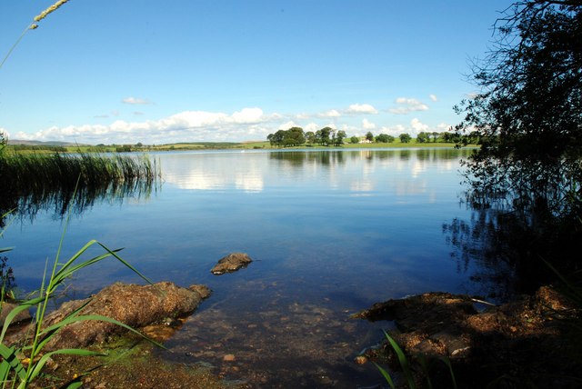
Milton Loch

Milton Loch is an alkaline freshwater loch located in Dumfries and Galloway, Scotland. In the loch and nearby are archaeological sites including three...

Nearby Amenities

Located within 500m of 55.073288,-3.8467993
Turner's Monument
Historic: monument
Lat/Long: 55.0731268/-3.8466798
The data included in this document is from www.openstreetmap.org. The data is made available under ODbL.

Have you been to Bennan?

Leave your review of Bennan below (or comments, questions and feedback).