Cnoc Ach' na h-Uai
Hill, Mountain in Sutherland
Scotland
Cnoc Ach' na h-Uai

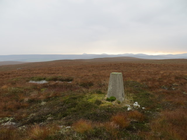
Cnoc Ach' na h-Uai is a prominent hill located in Sutherland, a county in the Highland region of Scotland. Standing at an elevation of approximately 350 meters (1148 feet), it offers breathtaking views of the surrounding landscapes.
The hill is characterized by its gently sloping terrain, covered in a mixture of heather, grasses, and scattered trees. Its summit is relatively flat, providing ample space for visitors to explore and take in the panoramic vistas of the nearby mountains, lochs, and glens.
Cnoc Ach' na h-Uai is a favorite spot among outdoor enthusiasts, hikers, and nature lovers. It boasts a variety of walking trails, ranging in difficulty from easy to moderate, ensuring that visitors of all fitness levels can enjoy its beauty. The hill is also a great location for birdwatching, as it attracts a diverse range of avian species, including buzzards, kestrels, and golden eagles.
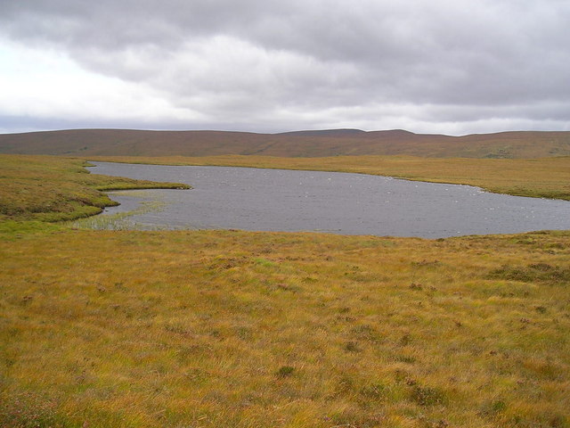
One of the notable features of Cnoc Ach' na h-Uai is a small, tranquil loch that sits at the base of the hill. This loch, surrounded by lush greenery and wildflowers, adds to the picturesque charm of the area and provides a serene setting for picnics or simply enjoying the peaceful ambiance.
Overall, Cnoc Ach' na h-Uai is a stunning natural landmark in Sutherland, offering visitors a chance to immerse themselves in the beauty of the Scottish Highlands and experience the tranquility of its surroundings.
If you have any feedback on the listing, please let us know in the comments section below.
Cnoc Ach' na h-Uai Images
Images are sourced within 2km of 58.274144/-4.0141376 or Grid Reference NC8133. Thanks to Geograph Open Source API. All images are credited.


Cnoc Ach' na h-Uai is located at Grid Ref: NC8133 (Lat: 58.274144, Lng: -4.0141376)
Unitary Authority: Highland
Police Authority: Highlands and Islands
What 3 Words
///whizzed.spinners.flash. Near Kinbrace, Highland
Nearby Locations
Related Wikis

Loch Achnamoine
Loch Achnamoine is a small mountain loch, situated on the River Helmsdale in the Highland council area of Scotland. The nearest settlement to it is Kinbrace...
Loch Badanloch
Loch Badanloch is a loch in Sutherland in the Highland Council Area of northern Scotland. The settlement on the lake is Bandanloch Lodge. The hamlet of...

Kinbrace
Kinbrace is a small village in Sutherland in the Highland council area of Scotland. It lies at the junction of the A897 and B871 and is 17 miles (27 km...

Kinbrace railway station
Kinbrace railway station is a railway station serving the village of Kinbrace in the Highland council area in the north of Scotland. It is located on the...

Achentoul
Achentoul (Scottish Gaelic: Achadh an t-Sabhail; translation: "field of the barn") is a hamlet in the Kinbrace area of Sutherland, in the Scottish council...

Loch Nan Clar
Loch Nan Clar is a loch in Sutherland in the Highland Council Area of northern Scotland. It is located near the B871 main road, and there is no settlement...

A897 road
The A897 single track road is entirely within the Highland council area of Scotland. It runs generally north from the A9 at Helmsdale to the A836 near...
Loch Rimsdale
Loch Rimsdale is a loch in the Farr parish in Sutherland in the Highland Council Area of northern Scotland. It is located near the B871 main road. There...
Have you been to Cnoc Ach' na h-Uai?
Leave your review of Cnoc Ach' na h-Uai below (or comments, questions and feedback).