An Eilrig

Hill, Mountain in Inverness-shire

Scotland

An Eilrig

Moorland,  Allt Coire Bhran Attempting to follow the faint traces of the Minigaig road. Many who cross the pass take a drier and easier route from Leathad an Taobhain to Glen Feshie rather than this difficult going towards Glen Tromie.
Moorland, Allt Coire Bhran Credit: Richard Webb

An Eilrig is a prominent hill located in Inverness-shire, a county in the Scottish Highlands. It is situated near the village of Carrbridge, about 20 miles southeast of the city of Inverness. With an elevation of approximately 1,480 feet (450 meters), An Eilrig is classified as a Corbett, which is a Scottish mountain between 2,500 and 3,000 feet (762 and 914 meters) in height.

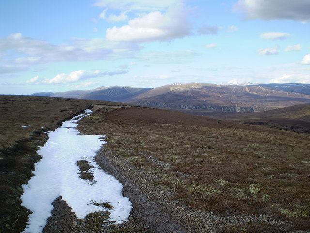
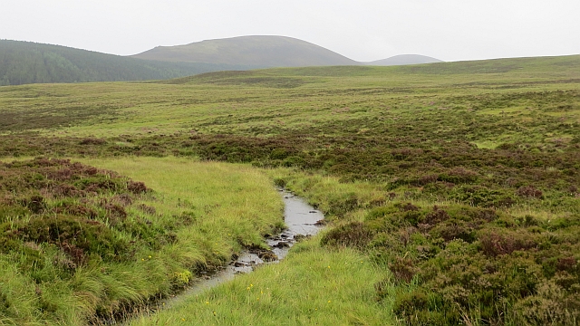
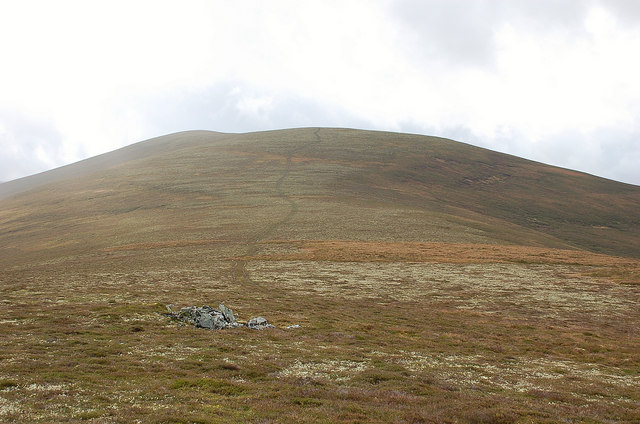
The hill is characterized by its rounded shape and offers stunning panoramic views of the surrounding area. From the summit, hikers can enjoy breathtaking vistas of the Cairngorms National Park, which boasts picturesque landscapes of mountains, forests, and lochs. On clear days, it is even possible to see as far as the Moray Firth and the North Sea.

The ascent to An Eilrig can be challenging but rewarding. The hill is accessible via a well-defined path that starts near Carrbridge and winds its way up through heather-covered slopes. Although the trail is relatively steep in some sections, it is manageable for experienced walkers and offers an enjoyable day out in the Scottish countryside.

An Eilrig is a popular destination for outdoor enthusiasts, attracting hikers, nature lovers, and photographers alike. It provides an opportunity to immerse oneself in the beauty of the Scottish Highlands and experience the tranquility of the surrounding wilderness. Whether seeking a physical challenge or simply a peaceful retreat, An Eilrig offers a memorable experience in the heart of Inverness-shire.

If you have any feedback on the listing, please let us know in the comments section below.

An Eilrig Images

Images are sourced within 2km of 56.966016/-3.950137 or Grid Reference NN8187. Thanks to Geograph Open Source API. All images are credited.

Moorland,  Allt Coire Bhran Attempting to follow the faint traces of the Minigaig road. Many who cross the pass take a drier and easier route from Leathad an Taobhain to Glen Feshie rather than this difficult going towards Glen Tromie.
Moorland, Allt Coire Bhran
Attempting to follow the faint traces of the Minigaig road. Many who cross the pass take a drier and easier route from Leathad an Taobhain to Glen Feshie rather than this difficult going towards Glen Tromie.
Footpath going north to Meall an Uillt Chreagaich The footpath descending north from an unnamed 912M top. The path then ascends Meall an Uillt Chreagaich where it joins a Land Rover track.
Footpath going north to Meall an Uillt Chreagaich
The footpath descending north from an unnamed 912M top. The path then ascends Meall an Uillt Chreagaich where it joins a Land Rover track.
Starting to climb the big hill Starting to climb to the highest point of the Minigaig, Leathad an Taobhain, where the track rises to 830 metres.
Starting to climb the big hill
Starting to climb to the highest point of the Minigaig, Leathad an Taobhain, where the track rises to 830 metres.
Deer on a hillside It's only when you catch the movement out the side of your eye that you realise the deer that have probably watched you for the last 20 minutes, are now well beyond decent photo distance.
Deer on a hillside
It's only when you catch the movement out the side of your eye that you realise the deer that have probably watched you for the last 20 minutes, are now well beyond decent photo distance.
Allt Coire Bhran
Allt Coire Bhran
It's raining again - oops, hand shielding lens in shot Looking back down the hill where the track is now a stream again.
It's raining again - oops, hand shielding lens in shot
Looking back down the hill where the track is now a stream again.
Guidance marker The route of the Minigaig track over the higher hills is marked by fairly prominent lumps of peat, with white gravel chips on top. These are easy to see looking down hill (see middle distance) but a bit more difficult looking up.
Guidance marker
The route of the Minigaig track over the higher hills is marked by fairly prominent lumps of peat, with white gravel chips on top. These are easy to see looking down hill (see middle distance) but a bit more difficult looking up.
North-east side of Leathad an Taobhain
Hill track on Meall an Uillt Chreagaich View NE towards Cairngorms (Cairn Toul to Sgor Gaoith)
Hill track on Meall an Uillt Chreagaich
View NE towards Cairngorms (Cairn Toul to Sgor Gaoith)
Hill track above Meur Mheadonach View to N, with Carn Dearg Mor beyond
Hill track above Meur Mheadonach
View to N, with Carn Dearg Mor beyond
Meall an Uillt Chreagach Meall an Uillt Chreagach from the upper slopes of Leathad an Taobhain. Remote country.
Meall an Uillt Chreagach
Meall an Uillt Chreagach from the upper slopes of Leathad an Taobhain. Remote country.
Ruined bothy on the bealach between Meall an Uillt Chreagaich and Leathad an Taobhain
Ascending south to the trig point at Point 912m This is the highest point on Leathad an Taobhain, though on the OS Landranger Map the name is applied to the 902m top approximately 1km south of west from the trig point.
Ascending south to the trig point at Point 912m
This is the highest point on Leathad an Taobhain, though on the OS Landranger Map the name is applied to the 902m top approximately 1km south of west from the trig point.
Moorland north of Leathad an Taobhain The heather gets deeper the lower down you go. Quite tough ground here.
Moorland north of Leathad an Taobhain
The heather gets deeper the lower down you go. Quite tough ground here.
Minigaig path Descent of the side of Coire Bhran. The path is indistinct (the tracked vehicle tracks soon go their own way, all the way to the left hand side of the prominent hill in the background (Meallach Mhòr).
Minigaig path
Descent of the side of Coire Bhran. The path is indistinct (the tracked vehicle tracks soon go their own way, all the way to the left hand side of the prominent hill in the background (Meallach Mhòr).
Minigaig, north side Not the mapped path, that is lost in the heather somewhere across a burn. Rough country even when drier than usual.
Minigaig, north side
Not the mapped path, that is lost in the heather somewhere across a burn. Rough country even when drier than usual.
Allt Coire-bhran Not the main burn but some braiding. The Minigaig path goes this way but is hard to trace on the ground.
Allt Coire-bhran
Not the main burn but some braiding. The Minigaig path goes this way but is hard to trace on the ground.
The head of Allt na Cuilce above Glen Tromie near Aviemore
Show me another place!

An Eilrig is located at Grid Ref: NN8187 (Lat: 56.966016, Lng: -3.950137)

Unitary Authority: Highland

Police Authority: Highlands and Islands

What 3 Words

///purifier.froze.munch. Near Kingussie, Highland

Nearby Locations

An Eilrig

Related Wikis

Càrn Dearg Mòr

Carn Dearg Mor (857 m) is a mountain in the Grampian Mountains of Scotland. It lies in the Badenoch and Strathspey area of Inverness-shire, east of the...

Kingdom of Scotland

The Kingdom of Scotland (Scottish Gaelic: Rìoghachd na h-Alba; Scots: Kinrick o Scotland, Norn: Kongungdum Skotland) was a sovereign state in northwest...

Scotland

Scotland (Scots: Scotland; Scottish Gaelic: Alba [ˈal̪ˠapə] ) is a country that is part of the United Kingdom. It contains nearly one-third of the United...

Battle of Craig Cailloch

The Battle of Craig Cailloch was a Scottish clan battle fought in 1441 between the Clan Cameron and Clan Mackintosh (who were part of the Chattan Confederation...

Grampian Mountains

The Grampian Mountains (Scottish Gaelic: Am Monadh) is one of the three major mountain ranges in Scotland, that together occupy about half of Scotland...

Mullach Clach a' Bhlàir

Mullach Clach a' Bhlàir or Meall Tional is a Munro in the Cairngorm mountain range of Scotland. == Sources ==

Carn an Fhidhleir

Carn an Fhidhleir (994 m) is a mountain in the Grampian Mountains of Scotland. It lies on the border of Inverness-shire, Perthshire and Aberdeenshire,...

Meall Chuaich

Meall Chuaich (951 m) is a mountain in the Grampian Mountains of Scotland, located east of the village of Dalwhinnie. Although the mountain lacks any distinctive...

Have you been to An Eilrig?

Leave your review of An Eilrig below (or comments, questions and feedback).